


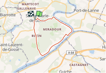


37 km | 45 km-effort


User


FREE GPS app for hiking
 SityTrail
IGN / Geographical institutes
SityTrail World
The world is yours!
Trail Walking of 11.9 km to be discovered at New Aquitaine, Landes, Sainte-Marie-de-Gosse. This trail is proposed by Ladyclairdelune74.
https://www.visorando.com/randonnee-boucle-de-l-adour-depuis-sainte-marie-de/
Publié par le Comité Départemental du Tourisme des Landes sous le nom de circuit de la basse vallée de l'Adour, cet itinéraire est repris ici pour l'utiliser avec Visorando.
Très belle boucle alternant sentiers vallonnés et points de vue sur le fleuve Adour.
Paysage vallonné, où se côtoient prairies, champs de maïs, vergers de kiwis.

Mountain bike

On foot
Walking
Mountain bike

Walking
Walking
Mountain bike
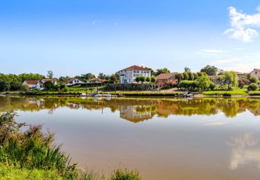
Très belle boucle sur des routes paisibles. De magnifiques maisons, le calme de l'Adour.