![](/images/other/stat-length.png)
![Trail Walking Neuilly-sur-Seine - Boucle Pont de Neuilly - Suresnes - Marne la coquette - Photo](https://media.geolcdn.com/t/1900/400/ext.pjpeg?maxdim=2&url=https%3A%2F%2Fmedia.geolcdn.com%2Ff%2F1298362c-7f2f-4997-8b20-24e249711f7b.jpg)
Boucle Pont de Neuilly - Suresnes - Marne la coquette
chessyca
User
![Length](/images/other/stat-length.png)
Length
28 km
![Max alt](https://static1.geolcdn.com/siteimages/upload/files/1508320355ic_sort_altitude_max_24dp.png)
Max alt
169 m
![Uphill gradient](https://static1.geolcdn.com/siteimages/upload/files/1508320355ic_sort_den_pos_24dp.png)
Uphill gradient
465 m
![Km-Effort](/images/other/stat-length.png)
Km-Effort
35 km
![Min alt](https://static1.geolcdn.com/siteimages/upload/files/1508320355ic_sort_altitude_min_24dp.png)
Min alt
24 m
![Downhill gradient](https://static1.geolcdn.com/siteimages/upload/files/1508320355ic_sort_den_neg_24dp.png)
Downhill gradient
436 m
![Boucle](https://static1.geolcdn.com/siteimages/upload/files/16400158638029165_repeat_loop_refresh_sync_direction_icon.png)
Boucle
No
Creation date :
2021-06-27 07:12:38.731
Updated on :
2021-06-27 19:20:08.61
![Walking](https://static1.geolcdn.com/sitytour/trail-icons/101.png)
6h12
Difficulty : Easy
![Scan this QR Code to open this trail in the SityTrail application](https://capi.geolives.com/qq0zvz2zws4bq2lad0pu/sitytour/trails/2841626/qr.png?size=200)
FREE GPS app for hiking
About
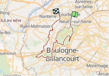
Trail Walking of 28 km to be discovered at Ile-de-France, Hauts-de-Seine, Neuilly-sur-Seine. This trail is proposed by chessyca.
Description
Dernière boucle > 25 km avant les vacances avec le RCY
Départ du Pont de Neuilly et fin de parcours avec une visite commentée du Cimetière américain de Suresnes
Un peu de dénivelé dans le coin
Parcours vraiment sympa
Positioning
Country:
France
Region :
Ile-de-France
Department/Province :
Hauts-de-Seine
Municipality :
Neuilly-sur-Seine
Location:
Unknown
Start:(Dec)
Start:(UTM)
445688 ; 5414928 (31U) N.
Comments
Trails nearby
![Trail Walking Paris - DP75-14 De Sèvres-Babylone au square Saint-Médard - Photo](https://media.geolcdn.com/t/375/260/ext.jpg?maxdim=2&url=https%3A%2F%2Fmedia.geolcdn.com%2Ff%2Fa199d31d-b175-4057-acc7-f0c89d3fc917.jpg)
![Walking Walking](https://static1.geolcdn.com/sitytour/trail-icons/101.png)
DP75-14 De Sèvres-Babylone au square Saint-Médard
Walking
Easy
(1)
Paris,
Ile-de-France,
Paris,
France
![](/images/other/stat-length.png)
5 km | 5.8 km-effort
1h 18min
![](https://static1.geolcdn.com/siteimages/upload/files/16400158638029165_repeat_loop_refresh_sync_direction_icon.png)
No
![Trail Walking Paris - DP75-11 De Boulainvilliers à pont du Garigliano - Photo](https://media.geolcdn.com/t/375/260/ext.jpg?maxdim=2&url=https%3A%2F%2Fmedia.geolcdn.com%2Ff%2F65f6b9b8-257b-4cb3-ae12-0b82159348dc.jpg)
![Walking Walking](https://static1.geolcdn.com/sitytour/trail-icons/101.png)
DP75-11 De Boulainvilliers à pont du Garigliano
Walking
Easy
(1)
Paris,
Ile-de-France,
Paris,
France
![](/images/other/stat-length.png)
4.7 km | 5.4 km-effort
1h 13min
![](https://static1.geolcdn.com/siteimages/upload/files/16400158638029165_repeat_loop_refresh_sync_direction_icon.png)
No
![Trail Walking Paris - DP75-10 De Invalides à Boulainvilliers - Photo](https://media.geolcdn.com/t/375/260/ext.jpg?maxdim=2&url=https%3A%2F%2Fmedia.geolcdn.com%2Ff%2F06e8c009-77c2-4d8d-a0b6-c63aa8c7d3f7.jpg)
![Walking Walking](https://static1.geolcdn.com/sitytour/trail-icons/101.png)
DP75-10 De Invalides à Boulainvilliers
Walking
Very easy
(1)
Paris,
Ile-de-France,
Paris,
France
![](/images/other/stat-length.png)
5.5 km | 7.1 km-effort
1h 36min
![](https://static1.geolcdn.com/siteimages/upload/files/16400158638029165_repeat_loop_refresh_sync_direction_icon.png)
No
![Trail Walking Paris - DP75-01 de Monceau à Guy Môquet - Photo](https://media.geolcdn.com/t/375/260/ext.jpg?maxdim=2&url=https%3A%2F%2Fmedia.geolcdn.com%2Ff%2F4fe927af-6700-4051-b3f2-26d2c637f461.jpg)
![Walking Walking](https://static1.geolcdn.com/sitytour/trail-icons/101.png)
DP75-01 de Monceau à Guy Môquet
Walking
Easy
(1)
Paris,
Ile-de-France,
Paris,
France
![](/images/other/stat-length.png)
3.9 km | 4.5 km-effort
1h 1min
![](https://static1.geolcdn.com/siteimages/upload/files/16400158638029165_repeat_loop_refresh_sync_direction_icon.png)
No
![Trail Walking Paris - DP75-32 De Charles-Michel à Plaisance - Photo](https://media.geolcdn.com/t/375/260/ext.jpg?maxdim=2&url=https%3A%2F%2Fmedia.geolcdn.com%2Ff%2F392c6463-e03b-44f3-85b1-02c32ee10469.jpg)
![Walking Walking](https://static1.geolcdn.com/sitytour/trail-icons/101.png)
DP75-32 De Charles-Michel à Plaisance
Walking
Easy
(1)
Paris,
Ile-de-France,
Paris,
France
![](/images/other/stat-length.png)
4.3 km | 5.1 km-effort
1h 10min
![](https://static1.geolcdn.com/siteimages/upload/files/16400158638029165_repeat_loop_refresh_sync_direction_icon.png)
No
![Trail Walking Paris - DP75-31 De Passy à Charles-Michel - Photo](https://media.geolcdn.com/t/375/260/ext.jpg?maxdim=2&url=https%3A%2F%2Fmedia.geolcdn.com%2Ff%2F96431e96-6d3c-47dc-91ae-d446da1f3a1d.jpg)
![Walking Walking](https://static1.geolcdn.com/sitytour/trail-icons/101.png)
DP75-31 De Passy à Charles-Michel
Walking
Easy
(1)
Paris,
Ile-de-France,
Paris,
France
![](/images/other/stat-length.png)
4.5 km | 5.6 km-effort
1h 16min
![](https://static1.geolcdn.com/siteimages/upload/files/16400158638029165_repeat_loop_refresh_sync_direction_icon.png)
No
![Trail Walking Paris - DP75-19 de Porte-Maillot à Europe - Photo](https://media.geolcdn.com/t/375/260/ext.jpg?maxdim=2&url=https%3A%2F%2Fmedia.geolcdn.com%2Ff%2F159be267-b3d1-40ca-b7c5-4227580bd0ba.jpg)
![Walking Walking](https://static1.geolcdn.com/sitytour/trail-icons/101.png)
DP75-19 de Porte-Maillot à Europe
Walking
Easy
(1)
Paris,
Ile-de-France,
Paris,
France
![](/images/other/stat-length.png)
4.2 km | 4.8 km-effort
1h 5min
![](https://static1.geolcdn.com/siteimages/upload/files/16400158638029165_repeat_loop_refresh_sync_direction_icon.png)
No
![Trail Cycle Paris - Paris au bord de Seine - Photo](https://media.geolcdn.com/t/375/260/ext.jpg?maxdim=2&url=https%3A%2F%2Fservices.sitytrail.com%2FGeolivesWS%2FDownloadMedia.ashx%3FTrailID%3D137119%26Media%3D20120703185331.jpg)
![Cycle Cycle](https://static1.geolcdn.com/sitytour/trail-icons/200.png)
Paris au bord de Seine
Cycle
Very easy
(1)
Paris,
Ile-de-France,
Paris,
France
![](/images/other/stat-length.png)
11.4 km | 14.2 km-effort
46min
![](https://static1.geolcdn.com/siteimages/upload/files/16400158638029165_repeat_loop_refresh_sync_direction_icon.png)
No
![Trail Walking Paris - DP75-20 D'Europe à Abbesses - Photo](https://media.geolcdn.com/t/375/260/ext.jpg?maxdim=2&url=https%3A%2F%2Fmedia.geolcdn.com%2Ff%2Fd682439e-3e3a-41a9-a650-7fa1d5c73231.jpg)
![Walking Walking](https://static1.geolcdn.com/sitytour/trail-icons/101.png)
DP75-20 D'Europe à Abbesses
Walking
Easy
(1)
Paris,
Ile-de-France,
Paris,
France
![](/images/other/stat-length.png)
3 km | 3.8 km-effort
51min
![](https://static1.geolcdn.com/siteimages/upload/files/16400158638029165_repeat_loop_refresh_sync_direction_icon.png)
No