![](/images/other/stat-length.png)
![Trail Walking Peyzac-le-Moustier - Payzac-le-moustier, St Leon s/ Vézère, la Roque St Christophe - Photo](https://media.geolcdn.com/t/1900/400/ext.pjpeg?maxdim=2&url=https%3A%2F%2Fmedia.geolcdn.com%2Ff%2F845b6569-72db-4cb1-94f1-432bdb78067b.jpg)
Payzac-le-moustier, St Leon s/ Vézère, la Roque St Christophe
jcc24
User
![Length](/images/other/stat-length.png)
Length
21 km
![Max alt](https://static1.geolcdn.com/siteimages/upload/files/1508320355ic_sort_altitude_max_24dp.png)
Max alt
230 m
![Uphill gradient](https://static1.geolcdn.com/siteimages/upload/files/1508320355ic_sort_den_pos_24dp.png)
Uphill gradient
485 m
![Km-Effort](/images/other/stat-length.png)
Km-Effort
27 km
![Min alt](https://static1.geolcdn.com/siteimages/upload/files/1508320355ic_sort_altitude_min_24dp.png)
Min alt
63 m
![Downhill gradient](https://static1.geolcdn.com/siteimages/upload/files/1508320355ic_sort_den_neg_24dp.png)
Downhill gradient
485 m
![Boucle](https://static1.geolcdn.com/siteimages/upload/files/16400158638029165_repeat_loop_refresh_sync_direction_icon.png)
Boucle
Yes
Creation date :
2021-06-27 07:57:25.804
Updated on :
2021-07-05 17:04:18.082
![Walking](https://static1.geolcdn.com/sitytour/trail-icons/101.png)
6h12
Difficulty : Difficult
![Scan this QR Code to open this trail in the SityTrail application](https://capi.geolives.com/qq0zvz2zws4bq2lad0pu/sitytour/trails/2841595/qr.png?size=200)
FREE GPS app for hiking
About
Trail Walking of 21 km to be discovered at New Aquitaine, Dordogne, Peyzac-le-Moustier. This trail is proposed by jcc24.
Description
Belle boucle le long de la Vézère et sur la cote de Jor. Paysages et falaises troglodytes en passant par le village typique de St Léon sur Vézère.
Positioning
Country:
France
Region :
New Aquitaine
Department/Province :
Dordogne
Municipality :
Peyzac-le-Moustier
Location:
Unknown
Start:(Dec)
Start:(UTM)
347045 ; 4984117 (31T) N.
Comments
Trails nearby
![Trail Electric bike Plazac - Sensei Lissac - Photo](https://media.geolcdn.com/t/375/260/ext.jpg?maxdim=2&url=https%3A%2F%2Fmedia.geolcdn.com%2Ff%2Fccd27d5e-9d83-44d7-a1a6-a717ab1146ce.jpg)
![Electric bike Electric bike](https://static1.geolcdn.com/sitytour/trail-icons/205.png)
Sensei Lissac
Electric bike
Medium
Plazac,
New Aquitaine,
Dordogne,
France
![](/images/other/stat-length.png)
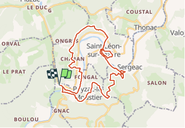
18.7 km | 26 km-effort
2h 26min
![](https://static1.geolcdn.com/siteimages/upload/files/16400158638029165_repeat_loop_refresh_sync_direction_icon.png)
Yes
![Trail Walking Saint-Léon-sur-Vézère - Boucle de Haute-Claire St Léon sur Vézère - Photo](https://media.geolcdn.com/t/375/260/ext.jpg?maxdim=2&url=https%3A%2F%2Fmedia.geolcdn.com%2Ff%2F6b8d4051-3369-48b4-85b3-aee55415b67f.jpg)
![Walking Walking](https://static1.geolcdn.com/sitytour/trail-icons/101.png)
Boucle de Haute-Claire St Léon sur Vézère
Walking
Medium
Saint-Léon-sur-Vézère,
New Aquitaine,
Dordogne,
France
![](/images/other/stat-length.png)
12.3 km | 17 km-effort
3h 8min
![](https://static1.geolcdn.com/siteimages/upload/files/16400158638029165_repeat_loop_refresh_sync_direction_icon.png)
Yes
![Trail Electric bike Tursac - Boucle Tursac la Vézère - Photo](https://media.geolcdn.com/t/375/260/ext.jpg?maxdim=2&url=https%3A%2F%2Fmedia.geolcdn.com%2Ff%2F5651ddcf-540e-4ccc-97b7-460cd96b3ffa.JPG)
![Electric bike Electric bike](https://static1.geolcdn.com/sitytour/trail-icons/205.png)
Boucle Tursac la Vézère
Electric bike
Easy
Tursac,
New Aquitaine,
Dordogne,
France
![](/images/other/stat-length.png)
22 km | 29 km-effort
2h 54min
![](https://static1.geolcdn.com/siteimages/upload/files/16400158638029165_repeat_loop_refresh_sync_direction_icon.png)
Yes
![Trail On foot Fleurac - Boucle de la Boissonie - Photo](https://media.geolcdn.com/t/375/260/ext.jpg?maxdim=2&url=https%3A%2F%2Fmedia.geolcdn.com%2Ff%2F10e99104-49c1-46cd-be73-6e6732ae592b.jpeg)
![On foot On foot](https://static1.geolcdn.com/sitytour/trail-icons/100.png)
Boucle de la Boissonie
On foot
Easy
Fleurac,
New Aquitaine,
Dordogne,
France
![](/images/other/stat-length.png)
6.1 km | 8.8 km-effort
1h 59min
![](https://static1.geolcdn.com/siteimages/upload/files/16400158638029165_repeat_loop_refresh_sync_direction_icon.png)
Yes
![Trail On foot Fleurac - Boucle de Lalande - Photo](https://media.geolcdn.com/t/375/260/ext.jpg?maxdim=2&url=https%3A%2F%2Fmedia.geolcdn.com%2Ff%2F10e99104-49c1-46cd-be73-6e6732ae592b.jpeg)
![On foot On foot](https://static1.geolcdn.com/sitytour/trail-icons/100.png)
Boucle de Lalande
On foot
Easy
Fleurac,
New Aquitaine,
Dordogne,
France
![](/images/other/stat-length.png)
14.1 km | 19.7 km-effort
4h 28min
![](https://static1.geolcdn.com/siteimages/upload/files/16400158638029165_repeat_loop_refresh_sync_direction_icon.png)
Yes
![Trail Walking Peyzac-le-Moustier - Sensei24. Roque saint christophe - Photo](https://media.geolcdn.com/t/375/260/ext.jpg?maxdim=2&url=https%3A%2F%2Fmedia.geolcdn.com%2Ff%2F91b857a2-44a5-482e-ba5b-0816305726ff.jpg)
![Walking Walking](https://static1.geolcdn.com/sitytour/trail-icons/101.png)
Sensei24. Roque saint christophe
Walking
Difficult
Peyzac-le-Moustier,
New Aquitaine,
Dordogne,
France
![](/images/other/stat-length.png)
16.2 km | 0 m-effort
4h 21min
![](https://static1.geolcdn.com/siteimages/upload/files/16400158638029165_repeat_loop_refresh_sync_direction_icon.png)
Yes
![Trail Walking Tursac - La Borie - Photo](https://media.geolcdn.com/t/375/260/ext.jpg?maxdim=2&url=https%3A%2F%2Fservices.sitytrail.com%2FGeolivesWS%2FDownloadMedia.ashx%3FTrailID%3D799194%26Media%3Dfix__20170730174739.jpg)
![Walking Walking](https://static1.geolcdn.com/sitytour/trail-icons/101.png)
![Trail Walking Tursac - la Borie - Photo](https://media.geolcdn.com/t/375/260/ext.jpg?maxdim=2&url=https%3A%2F%2Fservices.sitytrail.com%2FGeolivesWS%2FDownloadMedia.ashx%3FTrailID%3D799191%26Media%3Dfix__20170730174739.jpg)
![Walking Walking](https://static1.geolcdn.com/sitytour/trail-icons/101.png)
![Trail Walking Thonac - vezere_28reduit - Photo](https://media.geolcdn.com/t/375/260/ext.jpg?maxdim=2&url=https%3A%2F%2Fstatic1.geolcdn.com%2Fsiteimages%2Fupload%2Ffiles%2F1553511878bg_sport_marche.png)
![Walking Walking](https://static1.geolcdn.com/sitytour/trail-icons/101.png)
vezere_28reduit
Walking
Medium
(1)
Thonac,
New Aquitaine,
Dordogne,
France
![](/images/other/stat-length.png)
9.2 km | 13.1 km-effort
2h 48min
![](https://static1.geolcdn.com/siteimages/upload/files/16400158638029165_repeat_loop_refresh_sync_direction_icon.png)
Yes