![](/images/other/stat-length.png)
![Trail Walking Glandage - Grimone-Le Jocou 12km - Photo](https://media.geolcdn.com/t/1900/400/cd25f2bd-a51d-4184-be3b-7961b829b3e2.jpg&format=pjpeg&maxdim=2)
Grimone-Le Jocou 12km
thonyc
User GUIDE
![Length](/images/other/stat-length.png)
Length
12 km
![Max alt](https://static1.geolcdn.com/siteimages/upload/files/1508320355ic_sort_altitude_max_24dp.png)
Max alt
2036 m
![Uphill gradient](https://static1.geolcdn.com/siteimages/upload/files/1508320355ic_sort_den_pos_24dp.png)
Uphill gradient
926 m
![Km-Effort](/images/other/stat-length.png)
Km-Effort
24 km
![Min alt](https://static1.geolcdn.com/siteimages/upload/files/1508320355ic_sort_altitude_min_24dp.png)
Min alt
1115 m
![Downhill gradient](https://static1.geolcdn.com/siteimages/upload/files/1508320355ic_sort_den_neg_24dp.png)
Downhill gradient
925 m
![Boucle](https://static1.geolcdn.com/siteimages/upload/files/16400158638029165_repeat_loop_refresh_sync_direction_icon.png)
Boucle
Yes
Creation date :
2021-06-26 07:46:31.101
Updated on :
2021-11-24 16:44:49.963
![Walking](https://static1.geolcdn.com/sitytour/trail-icons/101.png)
6h00
Difficulty : Difficult
![Scan this QR Code to open this trail in the SityTrail application](https://capi.geolives.com/qq0zvz2zws4bq2lad0pu/sitytour/trails/2841246/qr.png?size=200)
FREE GPS app for hiking
About
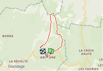
Trail Walking of 12 km to be discovered at Auvergne-Rhône-Alpes, Drôme, Glandage. This trail is proposed by thonyc.
Description
TRÈS IMPORTANT: montée au Jocou après le col de Seysse interdite l'été car présence troupeaux et patoux
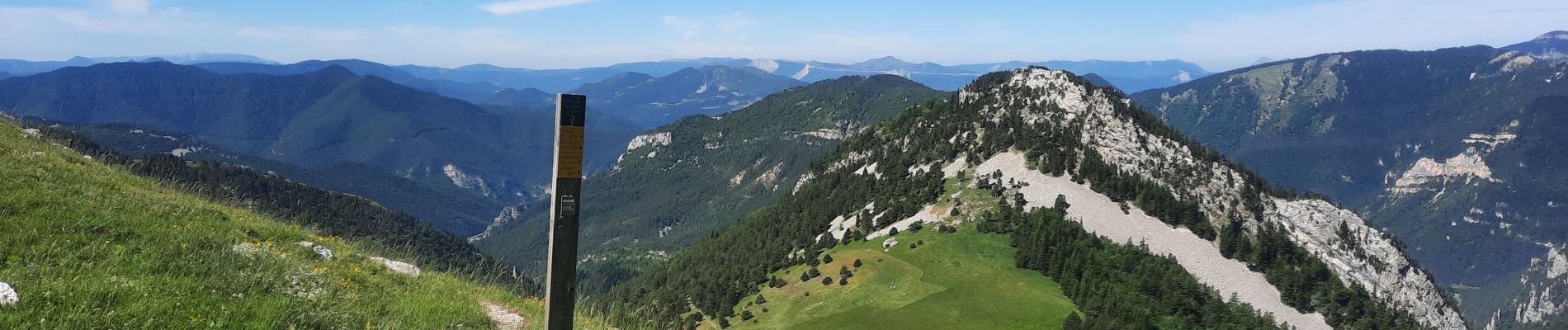
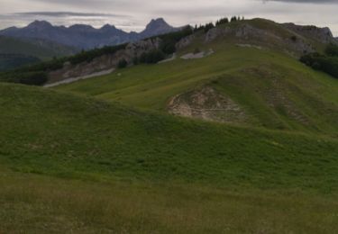
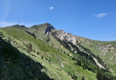
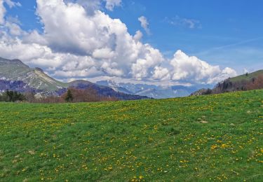
Panoramas exceptionnels
Forte montée après le col de Seysse pour atteindre la crête du Jocou
Passage vertigineux sans danger toutefois
Positioning
Country:
France
Region :
Auvergne-Rhône-Alpes
Department/Province :
Drôme
Municipality :
Glandage
Location:
Unknown
Start:(Dec)
Start:(UTM)
708766 ; 4952549 (31T) N.
Comments
Trails nearby
![Trail Walking Glandage - Le Jocou 2 - Photo](https://media.geolcdn.com/t/375/260/3db953da-6976-42b8-b004-e2f45e4d2956.jpg&format=jpg&maxdim=2)
![Walking Walking](https://static1.geolcdn.com/sitytour/trail-icons/101.png)
Le Jocou 2
Walking
Difficult
Glandage,
Auvergne-Rhône-Alpes,
Drôme,
France
![](/images/other/stat-length.png)
8.5 km | 18.1 km-effort
4h 0min
![](https://static1.geolcdn.com/siteimages/upload/files/16400158638029165_repeat_loop_refresh_sync_direction_icon.png)
Yes
![Trail Walking Glandage - 2022-09-05_12h23m25_Le Jocou-col de Seysse 12km.gpx (2).xml - Photo](https://media.geolcdn.com/t/375/260/7fa8e50f-0ae3-4fbb-b69e-805ffe4b1242.jpg&format=jpg&maxdim=2)
![Walking Walking](https://static1.geolcdn.com/sitytour/trail-icons/101.png)
2022-09-05_12h23m25_Le Jocou-col de Seysse 12km.gpx (2).xml
Walking
Very difficult
Glandage,
Auvergne-Rhône-Alpes,
Drôme,
France
![](/images/other/stat-length.png)
11.6 km | 24 km-effort
5h 27min
![](https://static1.geolcdn.com/siteimages/upload/files/16400158638029165_repeat_loop_refresh_sync_direction_icon.png)
Yes
![Trail Walking Glandage - 2022-06-24_19h10m37_Le Jocou par crêtes des Amousières 10km.gpx.xml - Photo](https://media.geolcdn.com/t/375/260/eeeff28a-8806-426d-aef8-2ba384b53865.jpg&format=jpg&maxdim=2)
![Walking Walking](https://static1.geolcdn.com/sitytour/trail-icons/101.png)
2022-06-24_19h10m37_Le Jocou par crêtes des Amousières 10km.gpx.xml
Walking
Very difficult
Glandage,
Auvergne-Rhône-Alpes,
Drôme,
France
![](/images/other/stat-length.png)
9.6 km | 22 km-effort
5h 9min
![](https://static1.geolcdn.com/siteimages/upload/files/16400158638029165_repeat_loop_refresh_sync_direction_icon.png)
Yes
![On foot On foot](https://static1.geolcdn.com/sitytour/trail-icons/100.png)
2024-04-17_Au fil du Buech
On foot
Easy
Lus-la-Croix-Haute,
Auvergne-Rhône-Alpes,
Drôme,
France
![](/images/other/stat-length.png)
7.5 km | 12.2 km-effort
2h 45min
![](https://static1.geolcdn.com/siteimages/upload/files/16400158638029165_repeat_loop_refresh_sync_direction_icon.png)
Yes
![On foot On foot](https://static1.geolcdn.com/sitytour/trail-icons/100.png)
2024-04-16_Sucettes de Borne
On foot
Difficult
Glandage,
Auvergne-Rhône-Alpes,
Drôme,
France
![](/images/other/stat-length.png)
18.7 km | 32 km-effort
7h 11min
![](https://static1.geolcdn.com/siteimages/upload/files/16400158638029165_repeat_loop_refresh_sync_direction_icon.png)
Yes
![On foot On foot](https://static1.geolcdn.com/sitytour/trail-icons/100.png)
2024-04-15_L'Aupillon
On foot
Medium
Lus-la-Croix-Haute,
Auvergne-Rhône-Alpes,
Drôme,
France
![](/images/other/stat-length.png)
8.3 km | 14.5 km-effort
3h 17min
![](https://static1.geolcdn.com/siteimages/upload/files/16400158638029165_repeat_loop_refresh_sync_direction_icon.png)
Yes
![Trail Walking Glandage - col menée - Photo](https://media.geolcdn.com/t/375/260/e241c69a-c216-4a1a-8e3f-904d3c89ecaa.jpg&format=jpg&maxdim=2)
![Walking Walking](https://static1.geolcdn.com/sitytour/trail-icons/101.png)
col menée
Walking
Medium
Glandage,
Auvergne-Rhône-Alpes,
Drôme,
France
![](/images/other/stat-length.png)
16.2 km | 28 km-effort
7h 10min
![](https://static1.geolcdn.com/siteimages/upload/files/16400158638029165_repeat_loop_refresh_sync_direction_icon.png)
No
![Trail Walking Lus-la-Croix-Haute - Antécime de La Toussière - Photo](https://media.geolcdn.com/t/375/260/87605781-6a50-4697-8890-c52173f8ef2c.jpg&format=jpg&maxdim=2)
![Walking Walking](https://static1.geolcdn.com/sitytour/trail-icons/101.png)
Antécime de La Toussière
Walking
Difficult
Lus-la-Croix-Haute,
Auvergne-Rhône-Alpes,
Drôme,
France
![](/images/other/stat-length.png)
8.6 km | 17.4 km-effort
5h 44min
![](https://static1.geolcdn.com/siteimages/upload/files/16400158638029165_repeat_loop_refresh_sync_direction_icon.png)
Yes
![Trail Walking Lalley - Serre Motaire et Lazare - Photo](https://media.geolcdn.com/t/375/260/7569b2e0-3d3e-4ed6-980b-6f2683deb4dc.jpg&format=jpg&maxdim=2)
![Walking Walking](https://static1.geolcdn.com/sitytour/trail-icons/101.png)
Serre Motaire et Lazare
Walking
Very difficult
Lalley,
Auvergne-Rhône-Alpes,
Isère,
France
![](/images/other/stat-length.png)
14.6 km | 24 km-effort
23h 45min
![](https://static1.geolcdn.com/siteimages/upload/files/16400158638029165_repeat_loop_refresh_sync_direction_icon.png)
Yes