![](/images/other/stat-length.png)
![Trail Walking Passy - SIXT PASSY RESERVE: LAC DE PORMENAZ - Photo](https://media.geolcdn.com/t/1900/400/3ca00d77-80a8-460b-a5dc-7402e436e3f5.jpg&format=pjpeg&maxdim=2)
SIXT PASSY RESERVE: LAC DE PORMENAZ
djeepee74
User
![Length](/images/other/stat-length.png)
![Max alt](https://static1.geolcdn.com/siteimages/upload/files/1508320355ic_sort_altitude_max_24dp.png)
![Uphill gradient](https://static1.geolcdn.com/siteimages/upload/files/1508320355ic_sort_den_pos_24dp.png)
![Km-Effort](/images/other/stat-length.png)
![Min alt](https://static1.geolcdn.com/siteimages/upload/files/1508320355ic_sort_altitude_min_24dp.png)
![Downhill gradient](https://static1.geolcdn.com/siteimages/upload/files/1508320355ic_sort_den_neg_24dp.png)
![Boucle](https://static1.geolcdn.com/siteimages/upload/files/16400158638029165_repeat_loop_refresh_sync_direction_icon.png)
![Walking](https://static1.geolcdn.com/sitytour/trail-icons/101.png)
5h45
Difficulty : Difficult
![Scan this QR Code to open this trail in the SityTrail application](https://capi.geolives.com/qq0zvz2zws4bq2lad0pu/sitytour/trails/2840010/qr.png?size=200)
FREE GPS app for hiking
About
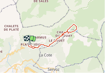
Trail Walking of 13.5 km to be discovered at Auvergne-Rhône-Alpes, Upper Savoy, Passy. This trail is proposed by djeepee74.
Description
BOUCLE... live 20210626
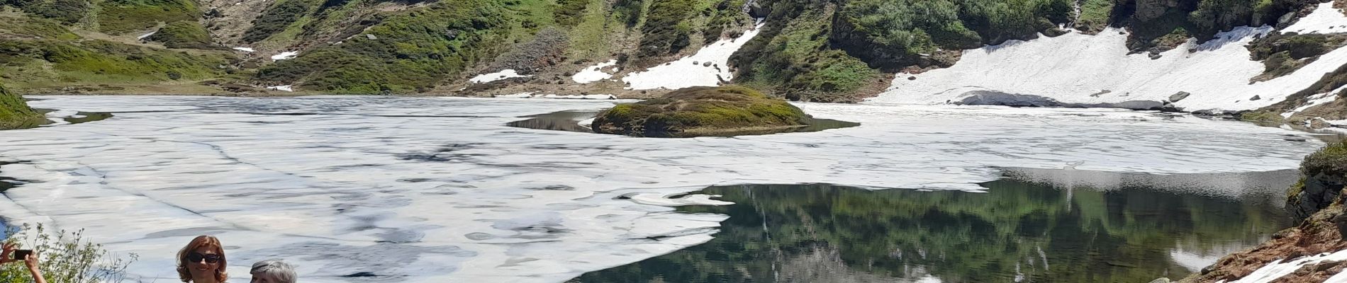
A partir des chalets de Souay, la montée se fait dans un couloir "la Chorde" avec passages d'escalade, bien sécurisés par des câbles et/ou échelles... durant les derniers 400 m. de dénivelé.
Lors de la descente du lac, avant de rejoindre Souay: quelques passages aériens sécurisés par câbles... "agrémentés" par la traversée d'un torrent (au Km 8,2).
Très belle randonnée physique, aux paysages magnifiques... avec le lac (et son île)... encore partiellement gelé cette année-là (26 juin 2021).
Positioning
Comments
Trails nearby
![Trail Walking Passy - Tour des Ayères - Passy Plaine-Joux - Photo](https://media.geolcdn.com/t/375/260/ext.jpg?maxdim=2&url=https%3A%2F%2Fservices.sitytrail.com%2FGeolivesWS%2FDownloadMedia.ashx%3FTrailID%3D172972%26Media%3D14459_6.jpg)
![Walking Walking](https://static1.geolcdn.com/sitytour/trail-icons/101.png)
Walking
![](/images/other/stat-length.png)
![](https://static1.geolcdn.com/siteimages/upload/files/16400158638029165_repeat_loop_refresh_sync_direction_icon.png)
![Trail Walking Passy - J10 - R8 - Plaine Joux - Les Ayères - Lac Vert - Photo](https://media.geolcdn.com/t/375/260/9c4651a9-0301-4065-a6bf-57814595ef3e.jpg&format=jpg&maxdim=2)
![Walking Walking](https://static1.geolcdn.com/sitytour/trail-icons/101.png)
Walking
![](/images/other/stat-length.png)
![](https://static1.geolcdn.com/siteimages/upload/files/16400158638029165_repeat_loop_refresh_sync_direction_icon.png)
![Trail Walking Passy - Plaine Joux Barmus Ayères Lac Vert - Photo](https://media.geolcdn.com/t/375/260/231e6d97-0ab1-4400-9dc1-f2b1dbc1d2c1.jpg&format=jpg&maxdim=2)
![Walking Walking](https://static1.geolcdn.com/sitytour/trail-icons/101.png)
Walking
![](/images/other/stat-length.png)
![](https://static1.geolcdn.com/siteimages/upload/files/16400158638029165_repeat_loop_refresh_sync_direction_icon.png)
![Trail Walking Passy - Tour de la chaine des Fiz par le passage du Dérochoir - Photo](https://media.geolcdn.com/t/375/260/ext.jpg?maxdim=2&url=https%3A%2F%2Fservices.sitytrail.com%2FGeolivesWS%2FDownloadMedia.ashx%3FTrailID%3D109367%26Media%3D3681_6.jpg)
![Walking Walking](https://static1.geolcdn.com/sitytour/trail-icons/101.png)
Walking
![](/images/other/stat-length.png)
![](https://static1.geolcdn.com/siteimages/upload/files/16400158638029165_repeat_loop_refresh_sync_direction_icon.png)
![Trail Walking Passy - Plaine Joux-Passage du derochoir-Col de Portette-Platé - Photo](https://media.geolcdn.com/t/375/260/a1a5c98a-bca0-41f5-b9f9-06d73967e2da.jpg&format=jpg&maxdim=2)
![Walking Walking](https://static1.geolcdn.com/sitytour/trail-icons/101.png)
Walking
![](/images/other/stat-length.png)
![](https://static1.geolcdn.com/siteimages/upload/files/16400158638029165_repeat_loop_refresh_sync_direction_icon.png)
![Trail Running Passy - grimpe de chedde ayeres - Photo](https://media.geolcdn.com/t/375/260/ext.jpg?maxdim=2&url=https%3A%2F%2Fstatic1.geolcdn.com%2Fsiteimages%2Fupload%2Ffiles%2F1524743154running.jpg)
![Running Running](https://static1.geolcdn.com/sitytour/trail-icons/103.png)
Running
![](/images/other/stat-length.png)
![](https://static1.geolcdn.com/siteimages/upload/files/16400158638029165_repeat_loop_refresh_sync_direction_icon.png)
![Trail Walking Passy - J27 - R25 - 🍂🍁 Plaine-Joux - Les Ayères - Lac Vert 🍁🍂
- Photo](https://media.geolcdn.com/t/375/260/b4952294-3c09-42c8-ac3d-e0aea2d811d5.jpg&format=jpg&maxdim=2)
![Walking Walking](https://static1.geolcdn.com/sitytour/trail-icons/101.png)
Walking
![](/images/other/stat-length.png)
![](https://static1.geolcdn.com/siteimages/upload/files/16400158638029165_repeat_loop_refresh_sync_direction_icon.png)
![Trail Walking Les Houches - J21 - R20 - La Fontaine - La Tour St Michel - Photo](https://media.geolcdn.com/t/375/260/41a493fe-e7d9-467b-8687-234bfad2b97b.jpg&format=jpg&maxdim=2)
![Walking Walking](https://static1.geolcdn.com/sitytour/trail-icons/101.png)
Walking
![](/images/other/stat-length.png)
![](https://static1.geolcdn.com/siteimages/upload/files/16400158638029165_repeat_loop_refresh_sync_direction_icon.png)
![Trail Walking Sixt-Fer-à-Cheval - Le tour des Fiz : J3 - Photo](https://media.geolcdn.com/t/375/260/9c7228c0-b1d1-422d-97b7-6cc678ab62a3.jpg&format=jpg&maxdim=2)
![Walking Walking](https://static1.geolcdn.com/sitytour/trail-icons/101.png)
Walking
![](/images/other/stat-length.png)
![](https://static1.geolcdn.com/siteimages/upload/files/16400158638029165_repeat_loop_refresh_sync_direction_icon.png)