![](/images/other/stat-length.png)
![Trail Walking Corbonod - GRAND COLOMBIER: SUR LYAND - CHARBEMENES par les crêtes - retour par LES PLATIERES - Photo](https://media.geolcdn.com/t/1900/400/ext.pjpeg?maxdim=2&url=https%3A%2F%2Fstatic1.geolcdn.com%2Fsiteimages%2Fupload%2Ffiles%2F1553511878bg_sport_marche.png)
GRAND COLOMBIER: SUR LYAND - CHARBEMENES par les crêtes - retour par LES PLATIERES
djeepee74
User
![Length](/images/other/stat-length.png)
Length
9.9 km
![Max alt](https://static1.geolcdn.com/siteimages/upload/files/1508320355ic_sort_altitude_max_24dp.png)
Max alt
1416 m
![Uphill gradient](https://static1.geolcdn.com/siteimages/upload/files/1508320355ic_sort_den_pos_24dp.png)
Uphill gradient
312 m
![Km-Effort](/images/other/stat-length.png)
Km-Effort
14.1 km
![Min alt](https://static1.geolcdn.com/siteimages/upload/files/1508320355ic_sort_altitude_min_24dp.png)
Min alt
1224 m
![Downhill gradient](https://static1.geolcdn.com/siteimages/upload/files/1508320355ic_sort_den_neg_24dp.png)
Downhill gradient
308 m
![Boucle](https://static1.geolcdn.com/siteimages/upload/files/16400158638029165_repeat_loop_refresh_sync_direction_icon.png)
Boucle
Yes
Creation date :
2021-06-25 15:57:19.52
Updated on :
2021-06-25 16:33:58.191
![Walking](https://static1.geolcdn.com/sitytour/trail-icons/101.png)
3h15
Difficulty : Medium
![Scan this QR Code to open this trail in the SityTrail application](https://capi.geolives.com/qq0zvz2zws4bq2lad0pu/sitytour/trails/2839124/qr.png?size=200)
FREE GPS app for hiking
About
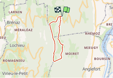
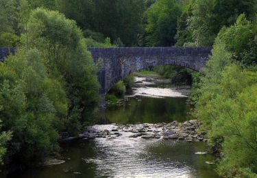
Trail Walking of 9.9 km to be discovered at Auvergne-Rhône-Alpes, Ain, Corbonod. This trail is proposed by djeepee74.
Description
BOUCLE... que l'on peut allonger en grimpant au "Grand Colombier" (Compter 210 m. de dénivelé positif supplémentaire, et ajouter une durée de 01:30)
Restauration possible "au belvédère de Sur Lyand"... nouveau numéro de téléphone: 33 9 74 76 60 50
Positioning
Country:
France
Region :
Auvergne-Rhône-Alpes
Department/Province :
Ain
Municipality :
Corbonod
Location:
Unknown
Start:(Dec)
Start:(UTM)
715171 ; 5092436 (31T) N.
Comments
Trails nearby
![Trail Walking Corbonod - GRAND COLOMBIER: SUR LYAND - CHARBEMENES - CHALET D'ARVIERES - Photo](https://media.geolcdn.com/t/375/260/23de9000-aeb2-412c-a056-3c3ba2ac6100.jpg&format=jpg&maxdim=2)
![Walking Walking](https://static1.geolcdn.com/sitytour/trail-icons/101.png)
GRAND COLOMBIER: SUR LYAND - CHARBEMENES - CHALET D'ARVIERES
Walking
Medium
(1)
Corbonod,
Auvergne-Rhône-Alpes,
Ain,
France
![](/images/other/stat-length.png)
13.5 km | 19.7 km-effort
4h 30min
![](https://static1.geolcdn.com/siteimages/upload/files/16400158638029165_repeat_loop_refresh_sync_direction_icon.png)
Yes
![Trail Walking Seyssel - 14-03-2022 Seyssel - La Montagne des Princes - Photo](https://media.geolcdn.com/t/375/260/2bb59beb-9357-4487-bc40-f89c52f27ae9.jpg&format=jpg&maxdim=2)
![Walking Walking](https://static1.geolcdn.com/sitytour/trail-icons/101.png)
14-03-2022 Seyssel - La Montagne des Princes
Walking
Medium
Seyssel,
Auvergne-Rhône-Alpes,
Upper Savoy,
France
![](/images/other/stat-length.png)
24 km | 35 km-effort
5h 57min
![](https://static1.geolcdn.com/siteimages/upload/files/16400158638029165_repeat_loop_refresh_sync_direction_icon.png)
Yes
![Trail Walking Arvière-en-Valromey - SUR LYAND NORD via corniche & balcon Valromey et GR9 - Photo](https://media.geolcdn.com/t/375/260/191d3346-6b07-4690-a9f2-9794339a2cee.jpg&format=jpg&maxdim=2)
![Walking Walking](https://static1.geolcdn.com/sitytour/trail-icons/101.png)
SUR LYAND NORD via corniche & balcon Valromey et GR9
Walking
Difficult
Arvière-en-Valromey,
Auvergne-Rhône-Alpes,
Ain,
France
![](/images/other/stat-length.png)
26 km | 36 km-effort
6h 35min
![](https://static1.geolcdn.com/siteimages/upload/files/16400158638029165_repeat_loop_refresh_sync_direction_icon.png)
Yes
![Trail Walking Motz - MOTZ SERRIERES: BORDS DU RHONE - Photo](https://media.geolcdn.com/t/375/260/d5979f91-e62c-40fa-96a4-fc46ef5f42b9.jpg&format=jpg&maxdim=2)
![Walking Walking](https://static1.geolcdn.com/sitytour/trail-icons/101.png)
MOTZ SERRIERES: BORDS DU RHONE
Walking
Difficult
Motz,
Auvergne-Rhône-Alpes,
Savoy,
France
![](/images/other/stat-length.png)
25 km | 30 km-effort
6h 43min
![](https://static1.geolcdn.com/siteimages/upload/files/16400158638029165_repeat_loop_refresh_sync_direction_icon.png)
Yes
![Trail Walking Corbonod - GRAND COLOMBIER: SUR LYAND - CHARBEMENES par les crêtes - COLOMBIER - RETOUR PAR VALLON D'ARVIERES - Photo](https://media.geolcdn.com/t/375/260/b12dfb88-143c-4b4b-96de-73aa15f6023a.jpg&format=jpg&maxdim=2)
![Walking Walking](https://static1.geolcdn.com/sitytour/trail-icons/101.png)
GRAND COLOMBIER: SUR LYAND - CHARBEMENES par les crêtes - COLOMBIER - RETOUR ...
Walking
Medium
Corbonod,
Auvergne-Rhône-Alpes,
Ain,
France
![](/images/other/stat-length.png)
14.5 km | 22 km-effort
4h 30min
![](https://static1.geolcdn.com/siteimages/upload/files/16400158638029165_repeat_loop_refresh_sync_direction_icon.png)
Yes
![Trail Walking Arvière-en-Valromey - Chalet d'Arvières - Photo](https://media.geolcdn.com/t/375/260/e14fe59e-874f-470f-857a-067bdc964819.jpg&format=jpg&maxdim=2)
![Walking Walking](https://static1.geolcdn.com/sitytour/trail-icons/101.png)
Chalet d'Arvières
Walking
Easy
Arvière-en-Valromey,
Auvergne-Rhône-Alpes,
Ain,
France
![](/images/other/stat-length.png)
10.5 km | 15.3 km-effort
3h 15min
![](https://static1.geolcdn.com/siteimages/upload/files/16400158638029165_repeat_loop_refresh_sync_direction_icon.png)
Yes
![Trail Walking Arvière-en-Valromey - GR 9 - Étape 13 - Chalet d’Arvières - Chanaz - Photo](https://media.geolcdn.com/t/375/260/e124169d-20c4-4d49-b21c-03de29e41215.jpg&format=jpg&maxdim=2)
![Walking Walking](https://static1.geolcdn.com/sitytour/trail-icons/101.png)
GR 9 - Étape 13 - Chalet d’Arvières - Chanaz
Walking
Very difficult
Arvière-en-Valromey,
Auvergne-Rhône-Alpes,
Ain,
France
![](/images/other/stat-length.png)
27 km | 0 m-effort
7h 33min
![](https://static1.geolcdn.com/siteimages/upload/files/16400158638029165_repeat_loop_refresh_sync_direction_icon.png)
No
![Trail Walking Corbonod - combe merlin - Photo](https://media.geolcdn.com/t/375/260/ext.jpg?maxdim=2&url=https%3A%2F%2Fservices.sitytrail.com%2FGeolivesWS%2FDownloadMedia.ashx%3FTrailID%3D1046732%26Media%3Dfix__20180926124253.jpg)
![Walking Walking](https://static1.geolcdn.com/sitytour/trail-icons/101.png)
combe merlin
Walking
Easy
Corbonod,
Auvergne-Rhône-Alpes,
Ain,
France
![](/images/other/stat-length.png)
9.9 km | 14.1 km-effort
2h 1min
![](https://static1.geolcdn.com/siteimages/upload/files/16400158638029165_repeat_loop_refresh_sync_direction_icon.png)
Yes
![Trail Walking Seyssel - Sur les Pas des Huguenots - Seyssel - Frangy - Photo](https://media.geolcdn.com/t/375/260/ext.jpg?maxdim=2&url=https%3A%2F%2Fservices.sitytrail.com%2FGeolivesWS%2FDownloadMedia.ashx%3FTrailID%3D129677%26Media%3D13209_5.jpg)
![Walking Walking](https://static1.geolcdn.com/sitytour/trail-icons/101.png)
Sur les Pas des Huguenots - Seyssel - Frangy
Walking
Difficult
Seyssel,
Auvergne-Rhône-Alpes,
Upper Savoy,
France
![](/images/other/stat-length.png)
15.4 km | 21 km-effort
5h 0min
![](https://static1.geolcdn.com/siteimages/upload/files/16400158638029165_repeat_loop_refresh_sync_direction_icon.png)
No