Trail On foot Pont-d'Ouilly - Pont d'ouilly chemin du Roy - Photo

Pont d'ouilly chemin du Roy

 lepompi
lepompi

User

© OpenStreetMap contributors
Length
Length
9.9 km
Max alt
Max alt
207 m
Uphill gradient
Uphill gradient
288 m
Km-Effort
Km-Effort  
13.8 km
Min alt
Min alt
72 m
Downhill gradient
Downhill gradient
293 m
Boucle
Boucle
Yes
Creation date :
2021-06-24 14:42:23.143
Updated on :
2021-06-24 14:46:27.464

(0 Reviews)

On foot
On foot
3h08
Difficulty : Easy

Scan this QR Code to open this trail in the SityTrail application

FREE GPS app for hiking

Logo SityTrail SityTrail

IGN / Geographical institutes

Download SityTrail from the App Store Download SityTrail from Google Play

Logo SityTrail SityTrail World

The world is yours!

Download SityTrail from the App Store Download SityTrail from Google Play Download SityTrail on Huawei AppGallery

About

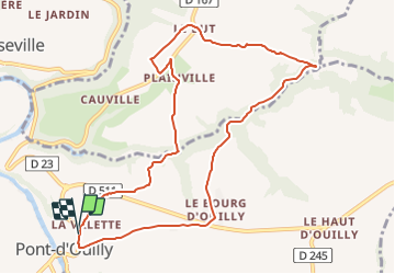
Trail On foot of 9.9 km to be discovered at Normandy, Calvados, Pont-d'Ouilly. This trail is proposed by lepompi.

Description

D'apres le tracé de Magny que j,ai corrigé

Sympa ,routes tres peu fréquentées !
bonne partie sur chemins

Elevation profile

Positioning

Country:
France
Region :
Normandy
Department/Province :
Calvados
Municipality :
Pont-d'Ouilly
Location:
Unknown
Start:(UTM)
690093 ; 5416957 (30U) N.

Trails nearby

Trail Mountain bike Pont-d'Ouilly - La Petite Suisse Normande 2014 - Pont-d'Ouilly - Photo
Mountain bike
tracegps

Mountain bike

Difficult
(1)
Pont-d'Ouilly, Normandy, Calvados, France
41 km | 54 km-effort
3h 30min
Yes
Trail Walking Le Vey - Clécy - Photo
Walking
zefreefly

Walking

Easy
(1)
Le Vey, Normandy, Calvados, France
14.8 km | 20 km-effort
3h 51min
Yes
Trail Walking Ménil-Hubert-sur-Orne - De Rouvroy aux Roches d'Oetre par le sentier des Méandres  - Photo
Walking
Ecureuiltrailer

Walking

Medium
Ménil-Hubert-sur-Orne, Normandy, Orne, France
7.1 km | 9.3 km-effort
2h 1min
Yes
Trail On foot Saint-Philbert-sur-Orne - Entre Orne et Rouvre - Photo
On foot
PRO

On foot

Easy
Saint-Philbert-sur-Orne, Normandy, Orne, France
7.7 km | 10.3 km-effort
2h 19min
Yes
Trail On foot Pont-d'Ouilly - Circuit du Val la Hère - Photo
On foot
PRO

On foot

Easy
Pont-d'Ouilly, Normandy, Calvados, France
6.7 km | 9.4 km-effort
2h 7min
Yes
Trail On foot Le Bô - Des Montagnes de Normandie? - Photo
On foot
PRO

On foot

Medium
Le Bô, Normandy, Calvados, France
15.4 km | 20 km-effort
4h 38min
No
Trail On foot La Pommeraye - Les Rochers de Briesvieille - Photo
On foot
PRO

On foot

Easy
La Pommeraye, Normandy, Calvados, France
9.1 km | 12.9 km-effort
2h 55min
No
Trail On foot Le Bô - Le Moulin à Papier - Photo
On foot
PRO

On foot

Easy
Le Bô, Normandy, Calvados, France
7.1 km | 9.6 km-effort
2h 11min
Yes
Trail On foot Le Mesnil-Villement - Tour du Pays de Falaise - Photo
On foot
PRO

On foot

Easy
Le Mesnil-Villement, Normandy, Calvados, France
8.6 km | 11.9 km-effort
2h 42min
No


Close
My subscriptions