Trail Walking Les Houches - TMB 01 - Les Houches -> Les Contamines - Photo

TMB 01 - Les Houches -> Les Contamines

 uru2010
uru2010

User

© OpenStreetMap contributors
Length
Length
16.5 km
Max alt
Max alt
1676 m
Uphill gradient
Uphill gradient
929 m
Km-Effort
Km-Effort  
28 km
Min alt
Min alt
995 m
Downhill gradient
Downhill gradient
801 m
Boucle
Boucle
No
Creation date :
2021-06-22 06:03:24.9
Updated on :
2022-05-08 14:23:33.311

(0 Reviews)

Walking
Walking
5h44
Difficulty : Medium

Scan this QR Code to open this trail in the SityTrail application

FREE GPS app for hiking

Logo SityTrail SityTrail

IGN / Geographical institutes

Download SityTrail from the App Store Download SityTrail from Google Play

Logo SityTrail SityTrail World

The world is yours!

Download SityTrail from the App Store Download SityTrail from Google Play Download SityTrail on Huawei AppGallery

About

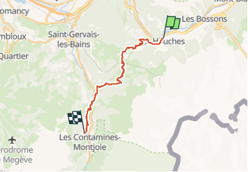
Trail Walking of 16.5 km to be discovered at Auvergne-Rhône-Alpes, Upper Savoy, Les Houches. This trail is proposed by uru2010.

Description

Départ : hôtel Chris-Tal, 242 avenue des Alpages, La Graz, Les Houches. Tél 04 50 54 50 55.
Arrivée : hôtel La Gélinotte, 91 chemin de La Revenaz, Les Contamines-Montjoie. Tél 04 50 47 01 61.
Via le col de Voza (2h30), Bionnassay ( 45 mn) et Les C-M ( 2h35).
Durée selon le guide : 5h50. Ma durée réelle : 5h44 !

Randonnée faite le 22/6/2021.
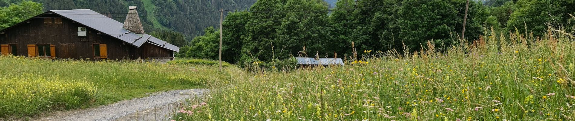
Temps nuageux à ensoleillé, très agréable pour marcher !

Elevation profile

Photos

Positioning

Country:
France
Region :
Auvergne-Rhône-Alpes
Department/Province :
Upper Savoy
Municipality :
Les Houches
Location:
Unknown
Start:(UTM)
329409 ; 5084589 (32T) N.

Trails nearby

Trail Walking Les Houches - 2024-05-29_17h11m02_christ-roi - Photo
Walking
GUIDE
mumu.larandonneuse

Walking

Easy
(1)
Les Houches, Auvergne-Rhône-Alpes, Upper Savoy, France
1.8 km | 4.2 km-effort
56min
No
Trail Walking Chamonix-Mont-Blanc - Glacier des Bossons Les Houches Chamonix - Photo
Walking
tracegps

Walking

Difficult
(2)
Chamonix-Mont-Blanc, Auvergne-Rhône-Alpes, Upper Savoy, France
13.1 km | 28 km-effort
5h 0min
Yes
Trail Walking Chamonix-Mont-Blanc - Chalet des Pyramides 1895m 11.7.22 - Photo
Walking
GUIDE
fredetpascale

Walking

Medium
Chamonix-Mont-Blanc, Auvergne-Rhône-Alpes, Upper Savoy, France
7.7 km | 15.2 km-effort
3h 30min
Yes
Trail Walking Chamonix-Mont-Blanc - La cascade du dard - Photo
Walking
GUIDE
pascalou73

Walking

Medium
Chamonix-Mont-Blanc, Auvergne-Rhône-Alpes, Upper Savoy, France
8.2 km | 13.6 km-effort
2h 0min
Yes
Trail Walking Chamonix-Mont-Blanc - Le lac bleus - Photo
Walking
GUIDE
pascalou73

Walking

Medium
Chamonix-Mont-Blanc, Auvergne-Rhône-Alpes, Upper Savoy, France
17.1 km | 35 km-effort
6h 57min
Yes
Trail Walking Les Houches - Chalets de Charlousse - Photo
Walking
YannPro81

Walking

Easy
(2)
Les Houches, Auvergne-Rhône-Alpes, Upper Savoy, France
9.2 km | 14.1 km-effort
2h 28min
Yes
Trail Walking Saint-Gervais-les-Bains - Descente au Glacier de Bionnassay depuis le Nid d''Aigle - Photo
Walking
GUIDE
pscheven

Walking

Very easy
(1)
Saint-Gervais-les-Bains, Auvergne-Rhône-Alpes, Upper Savoy, France
839 m | 1.9 km-effort
28min
No
Trail Walking Les Houches - J14 - R13 - La statue du Christ Roi - Photo
Walking
GUIDE
mumu.larandonneuse

Walking

Medium
Les Houches, Auvergne-Rhône-Alpes, Upper Savoy, France
2.3 km | 5.2 km-effort
56min
Yes
Trail Walking Les Houches - boucle aiguillette des houches ,refuge bel-lachat - Photo
Walking
carton-fils@orange.fr

Walking

Very difficult
Les Houches, Auvergne-Rhône-Alpes, Upper Savoy, France
10.4 km | 24 km-effort
2h 49min
Yes


Close
My subscriptions