![](/images/other/stat-length.png)
![Trail Walking Unknown - Monastère et traversée d'Amorgos - Photo](https://media.geolcdn.com/t/1900/400/ext.pjpeg?maxdim=2&url=https%3A%2F%2Fstatic1.geolcdn.com%2Fsiteimages%2Fupload%2Ffiles%2F1553511878bg_sport_marche.png)
Monastère et traversée d'Amorgos
Daniel.BRUN-PICARD
User
![Length](/images/other/stat-length.png)
Length
12.4 km
![Max alt](https://static1.geolcdn.com/siteimages/upload/files/1508320355ic_sort_altitude_max_24dp.png)
Max alt
422 m
![Uphill gradient](https://static1.geolcdn.com/siteimages/upload/files/1508320355ic_sort_den_pos_24dp.png)
Uphill gradient
452 m
![Km-Effort](/images/other/stat-length.png)
Km-Effort
19 km
![Min alt](https://static1.geolcdn.com/siteimages/upload/files/1508320355ic_sort_altitude_min_24dp.png)
Min alt
8 m
![Downhill gradient](https://static1.geolcdn.com/siteimages/upload/files/1508320355ic_sort_den_neg_24dp.png)
Downhill gradient
635 m
![Boucle](https://static1.geolcdn.com/siteimages/upload/files/16400158638029165_repeat_loop_refresh_sync_direction_icon.png)
Boucle
No
Creation date :
2021-06-20 08:09:40.232
Updated on :
2021-08-27 14:30:52.499
![Walking](https://static1.geolcdn.com/sitytour/trail-icons/101.png)
4h33
Difficulty : Difficult
![Scan this QR Code to open this trail in the SityTrail application](https://capi.geolives.com/qq0zvz2zws4bq2lad0pu/sitytour/trails/2833477/qr.png?size=200)
FREE GPS app for hiking
About
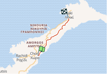
Trail Walking of 12.4 km to be discovered at Aegean, Naxos Regional Unit. This trail is proposed by Daniel.BRUN-PICARD.
Description
Monastère extraordinaire, points de vue splendides. La difficulté résulte du terrain très caillouteux. Il y a un petit restaurant sympatique à mi parcours, là où le tracé fait un petit crochet vers la droite.
Positioning
Country:
Greece
Region :
Aegean
Department/Province :
Naxos Regional Unit
Municipality :
Unknown
Location:
Unknown
Start:(Dec)
Start:(UTM)
402421 ; 4076737 (35S) N.
Comments
Trails nearby
![Trail Walking - Chora>>monastère >> chora>>katapola - Photo](https://media.geolcdn.com/t/375/260/e5bb279e-9a59-491f-b4af-37ced39e52ef.jpg&format=jpg&maxdim=2)
![Walking Walking](https://static1.geolcdn.com/sitytour/trail-icons/101.png)
Chora>>monastère >> chora>>katapola
Walking
Very difficult
,
Aegean,
Naxos Regional Unit,
Greece
![](/images/other/stat-length.png)
15.7 km | 24 km-effort
4h 51min
![](https://static1.geolcdn.com/siteimages/upload/files/16400158638029165_repeat_loop_refresh_sync_direction_icon.png)
No
![Trail Walking - chora à katapola - Photo](https://media.geolcdn.com/t/375/260/9b736b99-e0d1-42d3-88c8-249c261aa090.jpg&format=jpg&maxdim=2)
![Walking Walking](https://static1.geolcdn.com/sitytour/trail-icons/101.png)
chora à katapola
Walking
Medium
(1)
,
Aegean,
Naxos Regional Unit,
Greece
![](/images/other/stat-length.png)
3.8 km | 4.8 km-effort
1h 14min
![](https://static1.geolcdn.com/siteimages/upload/files/16400158638029165_repeat_loop_refresh_sync_direction_icon.png)
No
![Trail Walking - Monastère Chozoviotissa - Photo](https://media.geolcdn.com/t/375/260/dc16df41-f50c-4a57-8fbb-6f25233cef55.jpg&format=jpg&maxdim=2)
![Walking Walking](https://static1.geolcdn.com/sitytour/trail-icons/101.png)
Monastère Chozoviotissa
Walking
,
Aegean,
Naxos Regional Unit,
Greece
![](/images/other/stat-length.png)
12.3 km | 22 km-effort
4h 6min
![](https://static1.geolcdn.com/siteimages/upload/files/16400158638029165_repeat_loop_refresh_sync_direction_icon.png)
Yes
![Trail sport - Amorgos 24 monastère - Photo](https://media.geolcdn.com/t/375/260/a16e9356-b52d-46aa-8225-23703bb67210.jpg&format=jpg&maxdim=2)
Amorgos 24 monastère
sport
Very easy
,
Aegean,
Naxos Regional Unit,
Greece
![](/images/other/stat-length.png)
17.1 km | 28 km-effort
Unknown
![](https://static1.geolcdn.com/siteimages/upload/files/16400158638029165_repeat_loop_refresh_sync_direction_icon.png)
No
![Trail Walking - Katapola>> barrage >>plage >>Minoa>>Katapola - Photo](https://media.geolcdn.com/t/375/260/3212fcb7-1d0b-4066-9805-37ddb7f32750.jpg&format=jpg&maxdim=2)
![Walking Walking](https://static1.geolcdn.com/sitytour/trail-icons/101.png)
Katapola>> barrage >>plage >>Minoa>>Katapola
Walking
Very difficult
,
Aegean,
Naxos Regional Unit,
Greece
![](/images/other/stat-length.png)
13.8 km | 21 km-effort
4h 23min
![](https://static1.geolcdn.com/siteimages/upload/files/16400158638029165_repeat_loop_refresh_sync_direction_icon.png)
No
![Trail Walking - Katapola>>chora - Photo](https://media.geolcdn.com/t/375/260/8d910ca7-9f79-4605-add1-aa0c32baae28.jpg&format=jpg&maxdim=2)
![Walking Walking](https://static1.geolcdn.com/sitytour/trail-icons/101.png)
Katapola>>chora
Walking
Medium
,
Aegean,
Naxos Regional Unit,
Greece
![](/images/other/stat-length.png)
4.2 km | 7.5 km-effort
1h 25min
![](https://static1.geolcdn.com/siteimages/upload/files/16400158638029165_repeat_loop_refresh_sync_direction_icon.png)
No
![Trail Walking - monastère et plage asiatique anna - Photo](https://media.geolcdn.com/t/375/260/07e769a5-9cc2-4343-bbef-6de59e759fe4.jpg&format=jpg&maxdim=2)
![Walking Walking](https://static1.geolcdn.com/sitytour/trail-icons/101.png)
monastère et plage asiatique anna
Walking
Medium
,
Aegean,
Naxos Regional Unit,
Greece
![](/images/other/stat-length.png)
7.4 km | 14.1 km-effort
4h 11min
![](https://static1.geolcdn.com/siteimages/upload/files/16400158638029165_repeat_loop_refresh_sync_direction_icon.png)
No
![Trail Walking - Amorgos - Ruines de Minos et plage - Photo](https://media.geolcdn.com/t/375/260/48ea6731-8ae3-4637-b196-fd03fcd3d73d.jpg&format=jpg&maxdim=2)
![Walking Walking](https://static1.geolcdn.com/sitytour/trail-icons/101.png)
Amorgos - Ruines de Minos et plage
Walking
Easy
,
Aegean,
Naxos Regional Unit,
Greece
![](/images/other/stat-length.png)
10.4 km | 15.8 km-effort
3h 14min
![](https://static1.geolcdn.com/siteimages/upload/files/16400158638029165_repeat_loop_refresh_sync_direction_icon.png)
Yes
![Trail Walking - 2022-05-23_12h12m37_0906_6setrdzp8_Walking-Path-7-Evangeistria-Amorgos - Photo](https://media.geolcdn.com/t/375/260/ext.jpg?maxdim=2&url=https%3A%2F%2Fstatic1.geolcdn.com%2Fsiteimages%2Fupload%2Ffiles%2F1553511878bg_sport_marche.png)
![Walking Walking](https://static1.geolcdn.com/sitytour/trail-icons/101.png)
2022-05-23_12h12m37_0906_6setrdzp8_Walking-Path-7-Evangeistria-Amorgos
Walking
Easy
,
Aegean,
Naxos Regional Unit,
Greece
![](/images/other/stat-length.png)
3.7 km | 5.5 km-effort
1h 14min
![](https://static1.geolcdn.com/siteimages/upload/files/16400158638029165_repeat_loop_refresh_sync_direction_icon.png)
Yes