![](/images/other/stat-length.png)
![Trail Mountain bike Monnetier-Mornex - MONNETIER LES VOIRONS RETOUR MENOGE - Photo](https://media.geolcdn.com/t/1900/400/4f8e30d6-aa7b-4cc6-96f3-61cd12b53cdf.jpg&format=pjpeg&maxdim=2)
MONNETIER LES VOIRONS RETOUR MENOGE
leclaude74
User
![Length](/images/other/stat-length.png)
Length
58 km
![Max alt](https://static1.geolcdn.com/siteimages/upload/files/1508320355ic_sort_altitude_max_24dp.png)
Max alt
1350 m
![Uphill gradient](https://static1.geolcdn.com/siteimages/upload/files/1508320355ic_sort_den_pos_24dp.png)
Uphill gradient
1396 m
![Km-Effort](/images/other/stat-length.png)
Km-Effort
77 km
![Min alt](https://static1.geolcdn.com/siteimages/upload/files/1508320355ic_sort_altitude_min_24dp.png)
Min alt
400 m
![Downhill gradient](https://static1.geolcdn.com/siteimages/upload/files/1508320355ic_sort_den_neg_24dp.png)
Downhill gradient
1395 m
![Boucle](https://static1.geolcdn.com/siteimages/upload/files/16400158638029165_repeat_loop_refresh_sync_direction_icon.png)
Boucle
Yes
Creation date :
2021-06-20 05:49:48.157
Updated on :
2021-07-04 20:08:18.594
![Mountain bike](https://static1.geolcdn.com/sitytour/trail-icons/202.png)
4h17
Difficulty : Difficult
![Scan this QR Code to open this trail in the SityTrail application](https://capi.geolives.com/qq0zvz2zws4bq2lad0pu/sitytour/trails/2833135/qr.png?size=200)
FREE GPS app for hiking
About
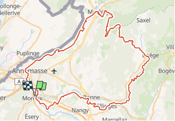
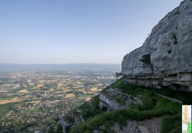
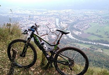
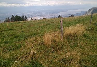
Trail Mountain bike of 58 km to be discovered at Auvergne-Rhône-Alpes, Upper Savoy, Monnetier-Mornex. This trail is proposed by leclaude74.
Description
BELLE BOUCLE OU L'ON PEUT PARTIR DU PARKING DE LA MIGROS ETREMBIERES DIRECTION MACHILLY POUR MONTER SUR LES VOIRONS / BOEGE /RETOUR MENOGE .
DEPART EN VILLE POUR REJOINDRE LE STADE DE VILLE LA GRAND ET APRES C EST LE TOP!
Positioning
Country:
France
Region :
Auvergne-Rhône-Alpes
Department/Province :
Upper Savoy
Municipality :
Monnetier-Mornex
Location:
Monnetier-Mornex
Start:(Dec)
Start:(UTM)
287068 ; 5116416 (32T) N.
Comments
Trails nearby
![Trail Walking Monnetier-Mornex - Salève, circuit par la vire de la Corraterie - Photo](https://media.geolcdn.com/t/375/260/ext.jpg?maxdim=2&url=https%3A%2F%2Fservices.sitytrail.com%2FGeolivesWS%2FDownloadMedia.ashx%3FTrailID%3D172408%26Media%3D13754_1.jpg)
![Walking Walking](https://static1.geolcdn.com/sitytour/trail-icons/101.png)
Salève, circuit par la vire de la Corraterie
Walking
Medium
(3)
Monnetier-Mornex,
Auvergne-Rhône-Alpes,
Upper Savoy,
France
![](/images/other/stat-length.png)
9.6 km | 15.2 km-effort
3h 30min
![](https://static1.geolcdn.com/siteimages/upload/files/16400158638029165_repeat_loop_refresh_sync_direction_icon.png)
Yes
![Trail On foot Thônex - Pont Bochet - Sierne Veyrier - Photo](https://media.geolcdn.com/t/375/260/953bf812-f492-4f60-8e7a-6234796e86dc.jpeg&format=jpg&maxdim=2)
![On foot On foot](https://static1.geolcdn.com/sitytour/trail-icons/100.png)
Pont Bochet - Sierne Veyrier
On foot
Easy
Thônex,
Geneva,
Unknown,
Switzerland
![](/images/other/stat-length.png)
3.4 km | 3.7 km-effort
50min
![](https://static1.geolcdn.com/siteimages/upload/files/16400158638029165_repeat_loop_refresh_sync_direction_icon.png)
No
![Trail Walking Étrembières - Château Etrembières-Les Voûtes-Salève Observatoire - Photo](https://media.geolcdn.com/t/375/260/015a4621-3968-42ed-9ea3-83173bd5ccbc.jpg&format=jpg&maxdim=2)
![Walking Walking](https://static1.geolcdn.com/sitytour/trail-icons/101.png)
Château Etrembières-Les Voûtes-Salève Observatoire
Walking
Difficult
Étrembières,
Auvergne-Rhône-Alpes,
Upper Savoy,
France
![](/images/other/stat-length.png)
16.1 km | 29 km-effort
5h 3min
![](https://static1.geolcdn.com/siteimages/upload/files/16400158638029165_repeat_loop_refresh_sync_direction_icon.png)
Yes
![Trail Walking Monnetier-Mornex - sentier de la Sauge - Photo](https://media.geolcdn.com/t/375/260/c35518be-b219-456a-b639-b0d81d9789ec.jpg&format=jpg&maxdim=2)
![Walking Walking](https://static1.geolcdn.com/sitytour/trail-icons/101.png)
sentier de la Sauge
Walking
Medium
Monnetier-Mornex,
Auvergne-Rhône-Alpes,
Upper Savoy,
France
![](/images/other/stat-length.png)
9.6 km | 18.1 km-effort
3h 43min
![](https://static1.geolcdn.com/siteimages/upload/files/16400158638029165_repeat_loop_refresh_sync_direction_icon.png)
Yes
![Trail Mountain bike Reignier-Ésery - les Bornes 11 aout 31km - Photo](https://media.geolcdn.com/t/375/260/ext.jpg?maxdim=2&url=https%3A%2F%2Fstatic1.geolcdn.com%2Fsiteimages%2Fupload%2Ffiles%2F1524743154velo.jpg)
![Mountain bike Mountain bike](https://static1.geolcdn.com/sitytour/trail-icons/202.png)
les Bornes 11 aout 31km
Mountain bike
Very difficult
(1)
Reignier-Ésery,
Auvergne-Rhône-Alpes,
Upper Savoy,
France
![](/images/other/stat-length.png)
31 km | 41 km-effort
2h 51min
![](https://static1.geolcdn.com/siteimages/upload/files/16400158638029165_repeat_loop_refresh_sync_direction_icon.png)
Yes
![Trail Mountain bike Monnetier-Mornex - ETREMBIERES BALCON DE L ARVE - Photo](https://media.geolcdn.com/t/375/260/fb741536-4943-4b50-9fef-4bee09b8e01c.jpeg&format=jpg&maxdim=2)
![Mountain bike Mountain bike](https://static1.geolcdn.com/sitytour/trail-icons/202.png)
ETREMBIERES BALCON DE L ARVE
Mountain bike
Very difficult
Monnetier-Mornex,
Auvergne-Rhône-Alpes,
Upper Savoy,
France
![](/images/other/stat-length.png)
60 km | 77 km-effort
4h 48min
![](https://static1.geolcdn.com/siteimages/upload/files/16400158638029165_repeat_loop_refresh_sync_direction_icon.png)
Yes
![Trail Mountain bike Étrembières - ETREMBIERES LE SALEVE LE SAPPEY LA CROISETTE - Photo](https://media.geolcdn.com/t/375/260/df0ac700-1377-4355-a9d7-99b658d08b63.jpg&format=jpg&maxdim=2)
![Mountain bike Mountain bike](https://static1.geolcdn.com/sitytour/trail-icons/202.png)
ETREMBIERES LE SALEVE LE SAPPEY LA CROISETTE
Mountain bike
Difficult
Étrembières,
Auvergne-Rhône-Alpes,
Upper Savoy,
France
![](/images/other/stat-length.png)
38 km | 58 km-effort
3h 44min
![](https://static1.geolcdn.com/siteimages/upload/files/16400158638029165_repeat_loop_refresh_sync_direction_icon.png)
Yes
![Trail Cycle Reignier-Ésery - Reignier-Amancy - Photo](https://media.geolcdn.com/t/375/260/ext.jpg?maxdim=2&url=https%3A%2F%2Fstatic1.geolcdn.com%2Fsiteimages%2Fupload%2Ffiles%2F1524743154velo.jpg)
![Cycle Cycle](https://static1.geolcdn.com/sitytour/trail-icons/200.png)
Reignier-Amancy
Cycle
Very easy
(1)
Reignier-Ésery,
Auvergne-Rhône-Alpes,
Upper Savoy,
France
![](/images/other/stat-length.png)
23 km | 27 km-effort
Unknown
![](https://static1.geolcdn.com/siteimages/upload/files/16400158638029165_repeat_loop_refresh_sync_direction_icon.png)
Yes
![Trail Walking Étrembières - D'Etrembieres au Téléphérique du Salève - Photo](https://media.geolcdn.com/t/375/260/ext.jpg?maxdim=2&url=https%3A%2F%2Fservices.sitytrail.com%2FGeolivesWS%2FDownloadMedia.ashx%3FTrailID%3D820511%26Media%3D20170830202136.jpg)
![Walking Walking](https://static1.geolcdn.com/sitytour/trail-icons/101.png)
D'Etrembieres au Téléphérique du Salève
Walking
Difficult
Étrembières,
Auvergne-Rhône-Alpes,
Upper Savoy,
France
![](/images/other/stat-length.png)
13.4 km | 24 km-effort
2h 27min
![](https://static1.geolcdn.com/siteimages/upload/files/16400158638029165_repeat_loop_refresh_sync_direction_icon.png)
Yes