Trail Canoe - kayak Salavas - gorge de l Ardèche vallon - sauze - Photo

gorge de l Ardèche vallon - sauze

 David25400
David25400

User GUIDE

© OpenStreetMap contributors
Length
Length
30 km
Max alt
Max alt
174 m
Uphill gradient
Uphill gradient
864 m
Km-Effort
Km-Effort  
42 km
Min alt
Min alt
44 m
Downhill gradient
Downhill gradient
900 m
Boucle
Boucle
No
Creation date :
2021-06-12 07:47:06.084
Updated on :
2021-06-12 14:32:04.863

(0 Reviews)

Canoe - kayak
Canoe - kayak
6h05
Difficulty : Difficult

Scan this QR Code to open this trail in the SityTrail application

FREE GPS app for hiking

Logo SityTrail SityTrail

IGN / Geographical institutes

Download SityTrail from the App Store Download SityTrail from Google Play

Logo SityTrail SityTrail World

The world is yours!

Download SityTrail from the App Store Download SityTrail from Google Play Download SityTrail on Huawei AppGallery

About

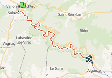
Trail Canoe - kayak of 30 km to be discovered at Auvergne-Rhône-Alpes, Ardèche, Salavas. This trail is proposed by David25400.

Description

Temps donné pour l entièreté de la balade pause comprise (environ 1h30).

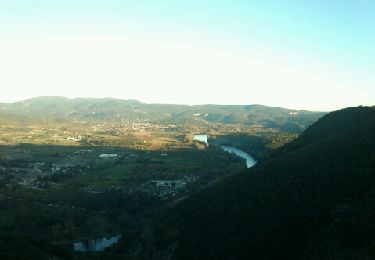
Très beau paysage, de nombreux oiseaux et quelques couleuvres à observer !

Un régal.

Descente faite avec Loulou bateau 👌

Elevation profile

Positioning

Country:
France
Region :
Auvergne-Rhône-Alpes
Department/Province :
Ardèche
Municipality :
Salavas
Location:
Unknown
Start:(UTM)
610541 ; 4916788 (31T) N.

Trails nearby

Trail Walking Vallon-Pont-d'Arc - vallon-chastelas - Photo
Walking
GUIDE
HERRY

Walking

Easy
(3)
Vallon-Pont-d'Arc, Auvergne-Rhône-Alpes, Ardèche, France
4.5 km | 6.2 km-effort
1h 19min
Yes
Trail Walking Labastide-de-Virac - 07 gorges ardeche - Photo
Walking
GUIDE
randodyssée

Walking

Easy
(1)
Labastide-de-Virac, Auvergne-Rhône-Alpes, Ardèche, France
13.7 km | 22 km-effort
5h 5min
Yes
Trail Walking Sampzon - Sampzon - Pas des pigeons - Photo
Walking
pb07

Walking

Easy
(3)
Sampzon, Auvergne-Rhône-Alpes, Ardèche, France
11.6 km | 17.1 km-effort
3h 11min
Yes
Trail Walking Vallon-Pont-d'Arc - Vallon pont d'arc au bivouac du gournier  - Photo
Walking
GUIDE
nadd73

Walking

Medium
Vallon-Pont-d'Arc, Auvergne-Rhône-Alpes, Ardèche, France
18.8 km | 31 km-effort
3h 45min
No
Trail On foot Lagorce - 07 baravon 05.03.23 - Photo
On foot
GUIDE
randodyssée

On foot

Easy
Lagorce, Auvergne-Rhône-Alpes, Ardèche, France
9.3 km | 14.2 km-effort
3h 13min
Yes
Trail Mountain bike Vallon-Pont-d'Arc - Vallon_Pont_d'Arc_20210712_092148 - Photo
Mountain bike
GUIDE
pascalou73

Mountain bike

Very easy
Vallon-Pont-d'Arc, Auvergne-Rhône-Alpes, Ardèche, France
27 km | 34 km-effort
Unknown
Yes
Trail Walking Salavas - 07 salavas pont de arc rieussec - Photo
Walking
GUIDE
randodyssée

Walking

Difficult
Salavas, Auvergne-Rhône-Alpes, Ardèche, France
16.4 km | 23 km-effort
7h 40min
Yes
Trail Walking Vallon-Pont-d'Arc - 07 grotte derocs chauvet - Photo
Walking
GUIDE
randodyssée

Walking

Difficult
Vallon-Pont-d'Arc, Auvergne-Rhône-Alpes, Ardèche, France
8.5 km | 14.5 km-effort
6h 18min
Yes
Trail Mountain bike Vallon-Pont-d'Arc - SityTrail - 2433385 - vtt-vallon-pont-arc-xpont-romain-et-dolmen-25-km - Photo
Mountain bike
GUIDE
pascalou73

Mountain bike

Difficult
Vallon-Pont-d'Arc, Auvergne-Rhône-Alpes, Ardèche, France
24 km | 33 km-effort
Unknown
No


Close
My subscriptions