Trail On foot Stosswihr - TOUR DU HOHNECK - Photo
 wirth
wirth

User

© OpenStreetMap contributors
Length
Length
18.7 km
Max alt
Max alt
1352 m
Uphill gradient
Uphill gradient
724 m
Km-Effort
Km-Effort  
28 km
Min alt
Min alt
947 m
Downhill gradient
Downhill gradient
717 m
Boucle
Boucle
Yes
Creation date :
2021-06-08 09:01:06.212
Updated on :
2021-06-08 09:13:34.003

(0 Reviews)

On foot
On foot
6h26
Difficulty : Medium
Trail
Trail
--
Difficulty : Very easy

Scan this QR Code to open this trail in the SityTrail application

FREE GPS app for hiking

Logo SityTrail SityTrail

IGN / Geographical institutes

Download SityTrail from the App Store Download SityTrail from Google Play

Logo SityTrail SityTrail World

The world is yours!

Download SityTrail from the App Store Download SityTrail from Google Play Download SityTrail on Huawei AppGallery

About

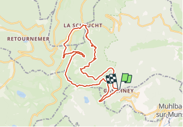
Trail On foot of 18.7 km to be discovered at Grand Est, Haut-Rhin, Stosswihr. This trail is proposed by wirth .

Description

Gaschney - Frankenthal - Col de la Schlucht - Jardin d'altitude - Trois Fours - Col du Falimont - Le Hohneck - Schaefferthal - Hinter Schalleren - FA Schissrothried - Le Gaschney

Elevation profile

Positioning

Country:
France
Region :
Grand Est
Department/Province :
Haut-Rhin
Municipality :
Stosswihr
Location:
Unknown
Start:(UTM)
354438 ; 5322006 (32U) N.

Trails nearby

Trail Walking Le Valtin - Les Rochers des Hirschsteine - Lac Vert - Photo
Walking
GUIDE
Michel1963

Walking

Difficult
(2)
Le Valtin, Grand Est, Vosges, France
14.4 km | 22 km-effort
5h 2min
Yes
Trail Walking Le Valtin - Le Sentier des Roches - Photo
Walking
GUIDE
Michel1963

Walking

Difficult
(2)
Le Valtin, Grand Est, Vosges, France
20 km | 34 km-effort
7h 43min
Yes
Trail Walking Stosswihr - Tour du belvedere avec le passage sur les crêtes  - Photo
Walking
ocepee

Walking

Very easy
(2)
Stosswihr, Grand Est, Haut-Rhin, France
8.5 km | 0 m-effort
2h 28min
Yes
Trail Walking La Bresse - Kastelberg des pierres, des lacs, des panoramas magnifiques  - Photo
Walking
Alfredy

Walking

Difficult
(1)
La Bresse, Grand Est, Vosges, France
15.1 km | 26 km-effort
6h 11min
Yes
Trail Walking Le Valtin - Les Hirschsteine - Photo
Walking
VacheKiri67

Walking

Difficult
(1)
Le Valtin, Grand Est, Vosges, France
16.1 km | 25 km-effort
6h 28min
Yes
Trail Walking La Bresse - Du Hohneck au Kastelberg par les Spietzkoepfe et le Sentier des Névées - Photo
Walking
tracegps

Walking

Very difficult
(3)
La Bresse, Grand Est, Vosges, France
7.6 km | 13.7 km-effort
3h 30min
Yes
Trail Walking La Bresse - Rainkopf - Mittlach - Hohneck - Photo
Walking
tracegps

Walking

Difficult
(1)
La Bresse, Grand Est, Vosges, France
22 km | 41 km-effort
8h 0min
Yes
Trail Mountain bike Metzeral - Tour du Gaschney par le Sattel - Photo
Mountain bike
tfg

Mountain bike

Difficult
(1)
Metzeral, Grand Est, Haut-Rhin, France
25 km | 37 km-effort
2h 32min
Yes
Trail Snowshoes Le Valtin - raquettes  - Photo
Snowshoes
vathi54

Snowshoes

Very easy
(1)
Le Valtin, Grand Est, Vosges, France
6.6 km | 9.4 km-effort
3h 8min
No


Close
My subscriptions