![](/images/other/stat-length.png)
![Trail Walking Châtillon-en-Diois - Vercors : Glandasse pas des clos Trace GPS du 06/06/2021 - Photo](https://media.geolcdn.com/t/1900/400/ext.pjpeg?maxdim=2&url=https%3A%2F%2Fstatic1.geolcdn.com%2Fsiteimages%2Fupload%2Ffiles%2F1553511878bg_sport_marche.png)
Vercors : Glandasse pas des clos Trace GPS du 06/06/2021
manumax
User
![Length](/images/other/stat-length.png)
Length
17.5 km
![Max alt](https://static1.geolcdn.com/siteimages/upload/files/1508320355ic_sort_altitude_max_24dp.png)
Max alt
1838 m
![Uphill gradient](https://static1.geolcdn.com/siteimages/upload/files/1508320355ic_sort_den_pos_24dp.png)
Uphill gradient
1345 m
![Km-Effort](/images/other/stat-length.png)
Km-Effort
35 km
![Min alt](https://static1.geolcdn.com/siteimages/upload/files/1508320355ic_sort_altitude_min_24dp.png)
Min alt
579 m
![Downhill gradient](https://static1.geolcdn.com/siteimages/upload/files/1508320355ic_sort_den_neg_24dp.png)
Downhill gradient
1344 m
![Boucle](https://static1.geolcdn.com/siteimages/upload/files/16400158638029165_repeat_loop_refresh_sync_direction_icon.png)
Boucle
Yes
Creation date :
2021-06-06 08:31:13.851
Updated on :
2021-06-12 10:40:51.136
![Walking](https://static1.geolcdn.com/sitytour/trail-icons/101.png)
8h14
Difficulty : Very difficult
![Scan this QR Code to open this trail in the SityTrail application](https://capi.geolives.com/qq0zvz2zws4bq2lad0pu/sitytour/trails/2816926/qr.png?size=200)
FREE GPS app for hiking
About
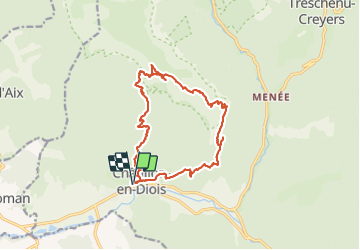
Trail Walking of 17.5 km to be discovered at Auvergne-Rhône-Alpes, Drôme, Châtillon-en-Diois. This trail is proposed by manumax.
Description
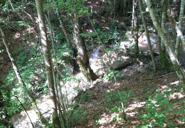
reconnaissance randonnées par pas des clots
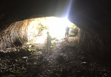
Passage pas des clots difficile avec vertige
Passage vertige avec une corde fixe en acier, le Harnais peut être bienvenu pour sécuriser
Positioning
Country:
France
Region :
Auvergne-Rhône-Alpes
Department/Province :
Drôme
Municipality :
Châtillon-en-Diois
Location:
Châtillon-en-Diois
Start:(Dec)
Start:(UTM)
696696 ; 4951990 (31T) N.
Comments
Trails nearby
![Trail Walking Châtillon-en-Diois - chatillon en Diois, GR91 - Photo](https://media.geolcdn.com/t/375/260/ext.jpg?maxdim=2&url=https%3A%2F%2Fstatic1.geolcdn.com%2Fsiteimages%2Fupload%2Ffiles%2F1553511878bg_sport_marche.png)
![Walking Walking](https://static1.geolcdn.com/sitytour/trail-icons/101.png)
chatillon en Diois, GR91
Walking
Difficult
(1)
Châtillon-en-Diois,
Auvergne-Rhône-Alpes,
Drôme,
France
![](/images/other/stat-length.png)
7.8 km | 14.3 km-effort
3h 14min
![](https://static1.geolcdn.com/siteimages/upload/files/16400158638029165_repeat_loop_refresh_sync_direction_icon.png)
Yes
![Trail Walking Châtillon-en-Diois - Pas des CLots - Photo](https://media.geolcdn.com/t/375/260/ext.jpg?maxdim=2&url=https%3A%2F%2Fstatic1.geolcdn.com%2Fsiteimages%2Fupload%2Ffiles%2F1553511878bg_sport_marche.png)
![Walking Walking](https://static1.geolcdn.com/sitytour/trail-icons/101.png)
Pas des CLots
Walking
Difficult
(1)
Châtillon-en-Diois,
Auvergne-Rhône-Alpes,
Drôme,
France
![](/images/other/stat-length.png)
16.1 km | 34 km-effort
7h 15min
![](https://static1.geolcdn.com/siteimages/upload/files/16400158638029165_repeat_loop_refresh_sync_direction_icon.png)
Yes
![Trail Walking Châtillon-en-Diois - glandasse par chatillon - Photo](https://media.geolcdn.com/t/375/260/ext.jpg?maxdim=2&url=https%3A%2F%2Fstatic1.geolcdn.com%2Fsiteimages%2Fupload%2Ffiles%2F1553511878bg_sport_marche.png)
![Walking Walking](https://static1.geolcdn.com/sitytour/trail-icons/101.png)
glandasse par chatillon
Walking
Medium
(1)
Châtillon-en-Diois,
Auvergne-Rhône-Alpes,
Drôme,
France
![](/images/other/stat-length.png)
15.4 km | 32 km-effort
4h 45min
![](https://static1.geolcdn.com/siteimages/upload/files/16400158638029165_repeat_loop_refresh_sync_direction_icon.png)
Yes
![Trail Walking Châtillon-en-Diois - 26 grotte pellebit en traversee zel - Photo](https://media.geolcdn.com/t/375/260/d6c0b607-c5a4-4107-b67d-2ad35a261578.jpg&format=jpg&maxdim=2)
![Walking Walking](https://static1.geolcdn.com/sitytour/trail-icons/101.png)
26 grotte pellebit en traversee zel
Walking
Medium
Châtillon-en-Diois,
Auvergne-Rhône-Alpes,
Drôme,
France
![](/images/other/stat-length.png)
14.1 km | 27 km-effort
7h 39min
![](https://static1.geolcdn.com/siteimages/upload/files/16400158638029165_repeat_loop_refresh_sync_direction_icon.png)
No
![Trail sport Châtillon-en-Diois - Châtillon en Diois col de Caux - Photo](https://media.geolcdn.com/t/375/260/c2c24153-915d-4a7e-8317-09a44e8b139f.jpg&format=jpg&maxdim=2)
Châtillon en Diois col de Caux
sport
Very easy
Châtillon-en-Diois,
Auvergne-Rhône-Alpes,
Drôme,
France
![](/images/other/stat-length.png)
12 km | 19.9 km-effort
Unknown
![](https://static1.geolcdn.com/siteimages/upload/files/16400158638029165_repeat_loop_refresh_sync_direction_icon.png)
Yes
![Walking Walking](https://static1.geolcdn.com/sitytour/trail-icons/101.png)
Pellebit
Walking
Very difficult
Châtillon-en-Diois,
Auvergne-Rhône-Alpes,
Drôme,
France
![](/images/other/stat-length.png)
14.2 km | 27 km-effort
6h 13min
![](https://static1.geolcdn.com/siteimages/upload/files/16400158638029165_repeat_loop_refresh_sync_direction_icon.png)
Yes
![Trail Walking Châtillon-en-Diois - Cabane de Chatillon - Photo](https://media.geolcdn.com/t/375/260/ea94f18f-fca1-490f-aab1-2356b5263731.jpg&format=jpg&maxdim=2)
![Walking Walking](https://static1.geolcdn.com/sitytour/trail-icons/101.png)
Cabane de Chatillon
Walking
Medium
Châtillon-en-Diois,
Auvergne-Rhône-Alpes,
Drôme,
France
![](/images/other/stat-length.png)
17.6 km | 37 km-effort
6h 4min
![](https://static1.geolcdn.com/siteimages/upload/files/16400158638029165_repeat_loop_refresh_sync_direction_icon.png)
No
![Trail Walking Châtillon-en-Diois - chatillon en Diois. les oursieres - Photo](https://media.geolcdn.com/t/375/260/ace35cbf-82be-45d6-acf9-562fc9f92be7.jpg&format=jpg&maxdim=2)
![Walking Walking](https://static1.geolcdn.com/sitytour/trail-icons/101.png)
chatillon en Diois. les oursieres
Walking
Difficult
Châtillon-en-Diois,
Auvergne-Rhône-Alpes,
Drôme,
France
![](/images/other/stat-length.png)
8.6 km | 15.1 km-effort
4h 42min
![](https://static1.geolcdn.com/siteimages/upload/files/16400158638029165_repeat_loop_refresh_sync_direction_icon.png)
Yes
![Trail Walking Châtillon-en-Diois - Chatillon en Diois la cabane - Photo](https://media.geolcdn.com/t/375/260/b72ec95b-4be8-438a-b0bc-6acf148e2da5.jpg&format=jpg&maxdim=2)
![Walking Walking](https://static1.geolcdn.com/sitytour/trail-icons/101.png)
Chatillon en Diois la cabane
Walking
Medium
Châtillon-en-Diois,
Auvergne-Rhône-Alpes,
Drôme,
France
![](/images/other/stat-length.png)
17 km | 33 km-effort
7h 9min
![](https://static1.geolcdn.com/siteimages/upload/files/16400158638029165_repeat_loop_refresh_sync_direction_icon.png)
Yes