Trail Horseback riding Val d'Oingt - bivouac Oingt retour  - Photo
© OpenStreetMap contributors
Length
Length
31 km
Max alt
Max alt
651 m
Uphill gradient
Uphill gradient
481 m
Km-Effort
Km-Effort  
39 km
Min alt
Min alt
185 m
Downhill gradient
Downhill gradient
888 m
Boucle
Boucle
No
Creation date :
2021-06-05 16:27:22.578
Updated on :
2021-06-05 16:29:24.413

(1 Reviews)

Horseback riding
Horseback riding
5h05
Difficulty : Difficult

Scan this QR Code to open this trail in the SityTrail application

FREE GPS app for hiking

Logo SityTrail SityTrail

IGN / Geographical institutes

Download SityTrail from the App Store Download SityTrail from Google Play

Logo SityTrail SityTrail World

The world is yours!

Download SityTrail from the App Store Download SityTrail from Google Play Download SityTrail on Huawei AppGallery

About

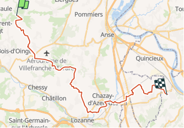
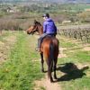
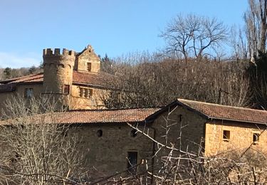
Trail Horseback riding of 31 km to be discovered at Auvergne-Rhône-Alpes, Rhône, Val d'Oingt. This trail is proposed by ben et nuts.

Elevation profile

Positioning

Country:
France
Region :
Auvergne-Rhône-Alpes
Department/Province :
Rhône
Municipality :
Val d'Oingt
Location:
Oingt
Start:(UTM)
623564 ; 5090264 (31T) N.

Comments

Please log in to post a review or rate the element


Trails nearby

Trail Walking Val d'Oingt - Oingt (69) Beaujolais  - Photo
Walking
Thomasdanielle

Walking

Very easy
(1)
Val d'Oingt, Auvergne-Rhône-Alpes, Rhône, France
9.3 km | 13.3 km-effort
2h 30min
Yes
Trail Electric bike Val d'Oingt - tour dans le beaujolais Oingt - Salles sur Arbuissonnas - Photo
Electric bike
cailloux54

Electric bike

Medium
(1)
Val d'Oingt, Auvergne-Rhône-Alpes, Rhône, France
52 km | 68 km-effort
5h 44min
Yes
Trail Walking Sainte-Paule - Sainte-Paule (13,4 km D. 485 m) - Photo
Walking
Thomasdanielle

Walking

Medium
(1)
Sainte-Paule, Auvergne-Rhône-Alpes, Rhône, France
13.4 km | 19.4 km-effort
4h 9min
Yes
Trail Walking Val d'Oingt - 69620-StLo-160412-Azergues+Genetière+Berthier - Photo
Walking
adye

Walking

Easy
(2)
Val d'Oingt, Auvergne-Rhône-Alpes, Rhône, France
5.2 km | 7.1 km-effort
1h 38min
Yes
Trail Walking Val d'Oingt - Saint-Laurent d'Oingt - Oingt, Plus beau Village de France - Photo
Walking
adye

Walking

Difficult
Val d'Oingt, Auvergne-Rhône-Alpes, Rhône, France
8.8 km | 12.5 km-effort
2h 20min
Yes
Trail Walking Val d'Oingt - 69620-Saint-Laurent d'Oingt-Bois d'Oingt : lavoirs, château et coteaux - Photo
Walking
adye

Walking

Medium
Val d'Oingt, Auvergne-Rhône-Alpes, Rhône, France
8 km | 11 km-effort
1h 57min
Yes
Trail Walking Theizé - Theizé (11 km - D. 310 m) - Photo
Walking
Thomasdanielle

Walking

Medium
Theizé, Auvergne-Rhône-Alpes, Rhône, France
11.3 km | 15.5 km-effort
2h 43min
Yes
Trail Walking Lacenas - Lacenas (11 km - D 310 m) RG - Photo
Walking
Thomasdanielle

Walking

Easy
Lacenas, Auvergne-Rhône-Alpes, Rhône, France
10.6 km | 14.7 km-effort
2h 38min
Yes
Trail Walking Val d'Oingt - Oingt en Beaujolais (13 km - D. 405 m) - Photo
Walking
Thomasdanielle

Walking

Medium
Val d'Oingt, Auvergne-Rhône-Alpes, Rhône, France
13.4 km | 18.8 km-effort
4h 58min
Yes


Close
My subscriptions