![](/images/other/stat-length.png)
![Trail Walking Plougasnou - Bretagne nord J5 De Plougasnou à Guimaec - Photo](https://media.geolcdn.com/t/1900/400/118e1567-0c85-46a5-ab8d-c11428bacbfb.jpg&format=pjpeg&maxdim=2)
Bretagne nord J5 De Plougasnou à Guimaec
chessyca
User GUIDE
![Length](/images/other/stat-length.png)
Length
21 km
![Max alt](https://static1.geolcdn.com/siteimages/upload/files/1508320355ic_sort_altitude_max_24dp.png)
Max alt
78 m
![Uphill gradient](https://static1.geolcdn.com/siteimages/upload/files/1508320355ic_sort_den_pos_24dp.png)
Uphill gradient
575 m
![Km-Effort](/images/other/stat-length.png)
Km-Effort
29 km
![Min alt](https://static1.geolcdn.com/siteimages/upload/files/1508320355ic_sort_altitude_min_24dp.png)
Min alt
0 m
![Downhill gradient](https://static1.geolcdn.com/siteimages/upload/files/1508320355ic_sort_den_neg_24dp.png)
Downhill gradient
533 m
![Boucle](https://static1.geolcdn.com/siteimages/upload/files/16400158638029165_repeat_loop_refresh_sync_direction_icon.png)
Boucle
No
Creation date :
2021-06-04 06:55:21.381
Updated on :
2021-06-08 10:10:39.737
![Walking](https://static1.geolcdn.com/sitytour/trail-icons/101.png)
5h51
Difficulty : Difficult
![Scan this QR Code to open this trail in the SityTrail application](https://capi.geolives.com/qq0zvz2zws4bq2lad0pu/sitytour/trails/2814217/qr.png?size=200)
FREE GPS app for hiking
About
Trail Walking of 21 km to be discovered at Brittany, Finistère, Plougasnou. This trail is proposed by chessyca.
Description
Une après midi bien corsé sur le GR 34
Attention : marcheur averti
Vérification des tiques à l'arrivée (beaucoup de passage en fougères hautes)
Hébergement au gite de Guimaec
Positioning
Country:
France
Region :
Brittany
Department/Province :
Finistère
Municipality :
Plougasnou
Location:
Unknown
Start:(Dec)
Start:(UTM)
438792 ; 5395075 (30U) N.
Comments
Trails nearby
![Trail Walking Saint-Jean-du-Doigt - St Jean du Doigt et la Côte de l'Armorique - Photo](https://media.geolcdn.com/t/375/260/ext.jpg?maxdim=2&url=https%3A%2F%2Fservices.sitytrail.com%2FGeolivesWS%2FDownloadMedia.ashx%3FTrailID%3D109363%26Media%3D3656_1.jpg)
![Walking Walking](https://static1.geolcdn.com/sitytour/trail-icons/101.png)
St Jean du Doigt et la Côte de l'Armorique
Walking
Very difficult
(1)
Saint-Jean-du-Doigt,
Brittany,
Finistère,
France
![](/images/other/stat-length.png)
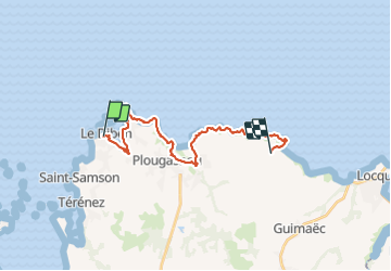
18.4 km | 24 km-effort
4h 30min
![](https://static1.geolcdn.com/siteimages/upload/files/16400158638029165_repeat_loop_refresh_sync_direction_icon.png)
Yes
![Trail Walking Plougasnou - Térénez-Barnenez - Photo](https://media.geolcdn.com/t/375/260/6aec81da-7722-49b0-9040-638ae7843a7d.jpg&format=jpg&maxdim=2)
![Walking Walking](https://static1.geolcdn.com/sitytour/trail-icons/101.png)
Térénez-Barnenez
Walking
Medium
Plougasnou,
Brittany,
Finistère,
France
![](/images/other/stat-length.png)
14.4 km | 17.4 km-effort
3h 16min
![](https://static1.geolcdn.com/siteimages/upload/files/16400158638029165_repeat_loop_refresh_sync_direction_icon.png)
Yes
![Trail Walking Plougasnou - GR 34 étape 23 - Photo](https://media.geolcdn.com/t/375/260/ext.jpg?maxdim=2&url=https%3A%2F%2Fservices.sitytrail.com%2FGeolivesWS%2FDownloadMedia.ashx%3FTrailID%3D318889%26Media%3Dfix__20140513155019.jpg)
![Walking Walking](https://static1.geolcdn.com/sitytour/trail-icons/101.png)
![Trail Walking Saint-Jean-du-Doigt - Randonnée de Saint Jean du Doigt à Primel Trégastel - Photo](https://media.geolcdn.com/t/375/260/ext.jpg?maxdim=2&url=https%3A%2F%2Fservices.sitytrail.com%2FGeolivesWS%2FDownloadMedia.ashx%3FTrailID%3D191603%26Media%3D15241_4.jpg)
![Walking Walking](https://static1.geolcdn.com/sitytour/trail-icons/101.png)
Randonnée de Saint Jean du Doigt à Primel Trégastel
Walking
Medium
Saint-Jean-du-Doigt,
Brittany,
Finistère,
France
![](/images/other/stat-length.png)
13 km | 16.2 km-effort
3h 0min
![](https://static1.geolcdn.com/siteimages/upload/files/16400158638029165_repeat_loop_refresh_sync_direction_icon.png)
Yes
![Trail Walking Saint-Jean-du-Doigt - De St Jean du Doigt à Plougasnou - Photo](https://media.geolcdn.com/t/375/260/ext.jpg?maxdim=2&url=https%3A%2F%2Fservices.sitytrail.com%2FGeolivesWS%2FDownloadMedia.ashx%3FTrailID%3D191395%26Media%3D14969_5.jpg)
![Walking Walking](https://static1.geolcdn.com/sitytour/trail-icons/101.png)
De St Jean du Doigt à Plougasnou
Walking
Easy
Saint-Jean-du-Doigt,
Brittany,
Finistère,
France
![](/images/other/stat-length.png)
4.9 km | 6.5 km-effort
1h 15min
![](https://static1.geolcdn.com/siteimages/upload/files/16400158638029165_repeat_loop_refresh_sync_direction_icon.png)
Yes
![Trail Walking Plougasnou - St. jean du doigtions - Photo](https://media.geolcdn.com/t/375/260/ext.jpg?maxdim=2&url=https%3A%2F%2Fservices.sitytrail.com%2FGeolivesWS%2FDownloadMedia.ashx%3FTrailID%3D173936%26Media%3D20130204145316.jpg)
![Walking Walking](https://static1.geolcdn.com/sitytour/trail-icons/101.png)
St. jean du doigtions
Walking
Easy
Plougasnou,
Brittany,
Finistère,
France
![](/images/other/stat-length.png)
13.4 km | 16.8 km-effort
4h 37min
![](https://static1.geolcdn.com/siteimages/upload/files/16400158638029165_repeat_loop_refresh_sync_direction_icon.png)
No
![Trail Walking Plouezoc'h - barnenez - Photo](https://media.geolcdn.com/t/375/260/348b96d9-3093-414c-bffe-8934cade33b9.jpg&format=jpg&maxdim=2)
![Walking Walking](https://static1.geolcdn.com/sitytour/trail-icons/101.png)
![Trail Walking Plouezoc'h - 2024-04-29 pointe de Barnénez - Morlaix - Photo](https://media.geolcdn.com/t/375/260/da644bda-65a3-4255-80f6-efdd549e7a5e.jpg&format=jpg&maxdim=2)
![Walking Walking](https://static1.geolcdn.com/sitytour/trail-icons/101.png)
2024-04-29 pointe de Barnénez - Morlaix
Walking
Medium
Plouezoc'h,
Brittany,
Finistère,
France
![](/images/other/stat-length.png)
9 km | 11.1 km-effort
2h 30min
![](https://static1.geolcdn.com/siteimages/upload/files/16400158638029165_repeat_loop_refresh_sync_direction_icon.png)
Yes
![Trail Walking Plougasnou - 2023-10-07 pointe Prinel Trégastel - Plougasnou 29 - Photo](https://media.geolcdn.com/t/375/260/a8ecdb1c-d036-47a5-aadb-2acc8a313ce0.jpg&format=jpg&maxdim=2)
![Walking Walking](https://static1.geolcdn.com/sitytour/trail-icons/101.png)
2023-10-07 pointe Prinel Trégastel - Plougasnou 29
Walking
Easy
Plougasnou,
Brittany,
Finistère,
France
![](/images/other/stat-length.png)
3.1 km | 3.7 km-effort
55min
![](https://static1.geolcdn.com/siteimages/upload/files/16400158638029165_repeat_loop_refresh_sync_direction_icon.png)
Yes