Trail Mountain bike La Roche-des-Arnauds - La Rivière - Photo

Les Hautes Alpes à découvrir ! GUIDE+

© OpenStreetMap contributors
Length
Length
38 km
Max alt
Max alt
1704 m
Uphill gradient
Uphill gradient
1180 m
Km-Effort
Km-Effort  
54 km
Min alt
Min alt
935 m
Downhill gradient
Downhill gradient
1176 m
Boucle
Boucle
Yes
Creation date :
2021-06-03 15:43:21.812
Updated on :
2021-08-14 07:56:03.168

(0 Reviews)

Mountain bike
Mountain bike
2h31
Difficulty : Difficult

Scan this QR Code to open this trail in the SityTrail application

FREE GPS app for hiking

Logo SityTrail SityTrail

IGN / Geographical institutes

Download SityTrail from the App Store Download SityTrail from Google Play

Logo SityTrail SityTrail World

The world is yours!

Download SityTrail from the App Store Download SityTrail from Google Play Download SityTrail on Huawei AppGallery

About

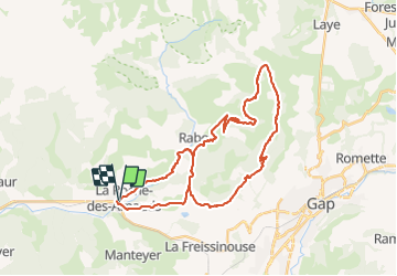
Trail Mountain bike of 38 km to be discovered at Provence-Alpes-Côte d'Azur, Hautes-Alpes, La Roche-des-Arnauds. This trail is proposed by Camping Les Rives du Lac.

Description

Tour très efficace car la montée sur la route puis la route forestière est rapide. Ensuite, single un peu montant, avec deux passages raides seulement. La descente depuis le col est assez rapide et pas technique, mais magnifique et très variée.
Fin de parcours le long du canal de Charance.
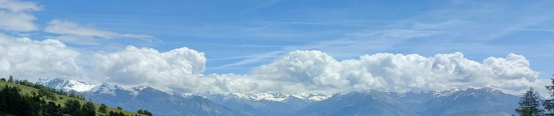
Très belles vues sur Bure puis ensuite sur les Ecrins, avant de dominer la ville de Gap.

Elevation profile

Photos

Positioning

Country:
France
Region :
Provence-Alpes-Côte d'Azur
Department/Province :
Hautes-Alpes
Municipality :
La Roche-des-Arnauds
Location:
Unknown
Start:(UTM)
734799 ; 4938560 (31T) N.

Trails nearby

Trail Walking Manteyer - R14   Pic de Ceuze - Photo
Walking
GUIDE+

Walking

Medium
(5)
Manteyer, Provence-Alpes-Côte d'Azur, Hautes-Alpes, France
9.6 km | 15.6 km-effort
4h 30min
Yes
Trail Mountain bike Manteyer - VTT32   aspremont - Photo
Mountain bike
GUIDE+

Mountain bike

Medium
(2)
Manteyer, Provence-Alpes-Côte d'Azur, Hautes-Alpes, France
21 km | 28 km-effort
2h 8min
No
Trail Walking Rabou - Rabou Tour du Puy - Photo
Walking
GUIDE
Marco05

Walking

Medium
Rabou, Provence-Alpes-Côte d'Azur, Hautes-Alpes, France
11.5 km | 21 km-effort
4h 46min
Yes
Trail Walking Manteyer - Tour de Ceüze - Photo
Walking
GUIDE
Marco05

Walking

Difficult
Manteyer, Provence-Alpes-Côte d'Azur, Hautes-Alpes, France
11.2 km | 20 km-effort
4h 34min
Yes
Trail Walking Rabou - Pic Melette - Photo
Walking
GUIDE
Marco05

Walking

Difficult
Rabou, Provence-Alpes-Côte d'Azur, Hautes-Alpes, France
9.8 km | 22 km-effort
4h 59min
Yes
Trail Walking Montmaur - Pic de Bure par combe d'Aurouze - Photo
Walking
GUIDE
Marco05

Walking

Very difficult
Montmaur, Provence-Alpes-Côte d'Azur, Hautes-Alpes, France
14.1 km | 33 km-effort
7h 24min
Yes
Trail Walking La Roche-des-Arnauds - Pic Chauve - Photo
Walking
GUIDE
Marco05

Walking

Difficult
La Roche-des-Arnauds, Provence-Alpes-Côte d'Azur, Hautes-Alpes, France
9.6 km | 21 km-effort
4h 42min
Yes
Trail Walking Montmaur - Col de Conode - Photo
Walking
GUIDE
Marco05

Walking

Medium
Montmaur, Provence-Alpes-Côte d'Azur, Hautes-Alpes, France
14.2 km | 22 km-effort
4h 58min
Yes
Trail On foot Rabou - 9587041 - Photo
On foot
GUIDE+

On foot

Easy
Rabou, Provence-Alpes-Côte d'Azur, Hautes-Alpes, France
6.6 km | 10.6 km-effort
3h 56min
No


Close
My subscriptions