Trail Walking Saint-Victor - Montplot - Photo
 neitag61
neitag61

User

© OpenStreetMap contributors
Length
Length
7.6 km
Max alt
Max alt
817 m
Uphill gradient
Uphill gradient
252 m
Km-Effort
Km-Effort  
11 km
Min alt
Min alt
609 m
Downhill gradient
Downhill gradient
254 m
Boucle
Boucle
Yes
Creation date :
2021-06-01 15:31:35.493
Updated on :
2021-06-01 15:33:39.068

(0 Reviews)

Walking
Walking
2h29
Difficulty : Medium

Scan this QR Code to open this trail in the SityTrail application

FREE GPS app for hiking

Logo SityTrail SityTrail

IGN / Geographical institutes

Download SityTrail from the App Store Download SityTrail from Google Play

Logo SityTrail SityTrail World

The world is yours!

Download SityTrail from the App Store Download SityTrail from Google Play Download SityTrail on Huawei AppGallery

About

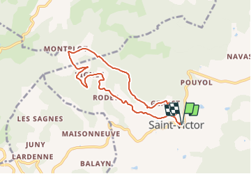
Trail Walking of 7.6 km to be discovered at Auvergne-Rhône-Alpes, Ardèche, Saint-Victor. This trail is proposed by neitag61.

Description

Une belle promenade en direction du hameau pittoresque de Montplot et offrant partout de superbes points de vue.Une belle promenade en direction du hameau pittoresque de Montplot et offrant partout de superbes points de vue.

Elevation profile

Points of interest

Point of interest Saint-Victor - 2 - Photo
neitag61
SAINT-VICTOR 

Positioning

Country:
France
Region :
Auvergne-Rhône-Alpes
Department/Province :
Ardèche
Municipality :
Saint-Victor
Location:
Unknown
Start:(UTM)
631672 ; 4995515 (31T) N.

Trails nearby

Trail On foot Saint-Félicien - Randonnée : Raillon - Photo
On foot
GUIDE+

On foot

Easy
Saint-Félicien, Auvergne-Rhône-Alpes, Ardèche, France
6.1 km | 8.6 km-effort
1h 57min
Yes
Trail On foot Saint-Victor - Randonnée : Montplot - Photo
On foot
GUIDE+

On foot

Easy
Saint-Victor, Auvergne-Rhône-Alpes, Ardèche, France
7.5 km | 10.9 km-effort
2h 28min
Yes
Trail On foot Saint-Félicien - Randonnée : Les Grands Massifs - Photo
On foot
GUIDE+

On foot

Difficult
Saint-Félicien, Auvergne-Rhône-Alpes, Ardèche, France
23 km | 32 km-effort
7h 21min
Yes
Trail On foot Saint-Félicien - Randonnée : Le Moulin des Gaillards - Photo
On foot
GUIDE+

On foot

Easy
Saint-Félicien, Auvergne-Rhône-Alpes, Ardèche, France
8.4 km | 12.6 km-effort
2h 51min
Yes
Trail On foot Saint-Félicien - Randonnée : De Saint-Félicien à Vaudevant - Photo
On foot
GUIDE+

On foot

Easy
Saint-Félicien, Auvergne-Rhône-Alpes, Ardèche, France
6 km | 9.1 km-effort
2h 3min
Yes
Trail On foot Saint-Victor - Randonnée : Tour du Pays de Saint-Félicien - Jour 3 - Photo
On foot
GUIDE+

On foot

Medium
Saint-Victor, Auvergne-Rhône-Alpes, Ardèche, France
17.5 km | 24 km-effort
5h 32min
No
Trail On foot Colombier-le-Vieux - Randonnée : Les Gorges de la Daronne - Photo
On foot
GUIDE+

On foot

Medium
Colombier-le-Vieux, Auvergne-Rhône-Alpes, Ardèche, France
14.8 km | 21 km-effort
4h 46min
Yes
Trail On foot Saint-Félicien - Randonnée : Tour du Pays de Saint-Félicien - Photo
On foot
GUIDE+

On foot

Difficult
Saint-Félicien, Auvergne-Rhône-Alpes, Ardèche, France
26 km | 37 km-effort
8h 29min
No
Trail On foot Saint-Félicien - Randonnée : La Daronne - Photo
On foot
GUIDE+

On foot

Easy
Saint-Félicien, Auvergne-Rhône-Alpes, Ardèche, France
9.2 km | 14 km-effort
3h 11min
No


Close
My subscriptions