![](/images/other/stat-length.png)
![Trail Walking Éveux - 69210Eveux-couvent_tourette-210523 - Photo](https://media.geolcdn.com/t/1900/400/ext.pjpeg?maxdim=2&url=https%3A%2F%2Fstatic1.geolcdn.com%2Fsiteimages%2Fupload%2Ffiles%2F1553511878bg_sport_marche.png)
69210Eveux-couvent_tourette-210523
adye
User
![Length](/images/other/stat-length.png)
Length
3.5 km
![Max alt](https://static1.geolcdn.com/siteimages/upload/files/1508320355ic_sort_altitude_max_24dp.png)
Max alt
399 m
![Uphill gradient](https://static1.geolcdn.com/siteimages/upload/files/1508320355ic_sort_den_pos_24dp.png)
Uphill gradient
65 m
![Km-Effort](/images/other/stat-length.png)
Km-Effort
4.4 km
![Min alt](https://static1.geolcdn.com/siteimages/upload/files/1508320355ic_sort_altitude_min_24dp.png)
Min alt
341 m
![Downhill gradient](https://static1.geolcdn.com/siteimages/upload/files/1508320355ic_sort_den_neg_24dp.png)
Downhill gradient
74 m
![Boucle](https://static1.geolcdn.com/siteimages/upload/files/16400158638029165_repeat_loop_refresh_sync_direction_icon.png)
Boucle
Yes
Creation date :
2021-05-23 14:08:19.912
Updated on :
2021-05-23 20:50:43.599
![Walking](https://static1.geolcdn.com/sitytour/trail-icons/101.png)
50m
Difficulty : Easy
![Scan this QR Code to open this trail in the SityTrail application](https://capi.geolives.com/qq0zvz2zws4bq2lad0pu/sitytour/trails/2799077/qr.png?size=200)
FREE GPS app for hiking
About
Trail Walking of 3.5 km to be discovered at Auvergne-Rhône-Alpes, Rhône, Éveux. This trail is proposed by adye.
Description
Le Couvent de La Tourette à #Eveux, classé au #patrimoinemondialdelunesco dans le cadre des 17 grandes réalisations de l'architecte #LeCorbusier
Positioning
Country:
France
Region :
Auvergne-Rhône-Alpes
Department/Province :
Rhône
Municipality :
Éveux
Location:
Unknown
Start:(Dec)
Start:(UTM)
626083 ; 5075401 (31T) N.
Comments
Trails nearby
![Trail Walking L'Arbresle - 2022-04-18_21h43m42_Fiche Verte n°9_L_Arbresle-1 - Photo](https://media.geolcdn.com/t/375/260/00218e51-a692-486e-8923-38995b6815db.jpg&format=jpg&maxdim=2)
![Walking Walking](https://static1.geolcdn.com/sitytour/trail-icons/101.png)
2022-04-18_21h43m42_Fiche Verte n°9_L_Arbresle-1
Walking
Medium
(1)
L'Arbresle,
Auvergne-Rhône-Alpes,
Rhône,
France
![](/images/other/stat-length.png)
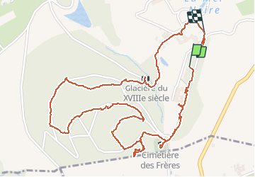
9.6 km | 11.8 km-effort
2h 40min
![](https://static1.geolcdn.com/siteimages/upload/files/16400158638029165_repeat_loop_refresh_sync_direction_icon.png)
Yes
![Trail Mountain bike Lozanne - La 5ème Vélozannaise (2014-VTT-45km) - Lozanne - Photo](https://media.geolcdn.com/t/375/260/ext.jpg?maxdim=2&url=https%3A%2F%2Fservices.sitytrail.com%2FGeolivesWS%2FDownloadMedia.ashx%3FTrailID%3D318042%26Media%3D17513_6.jpg)
![Mountain bike Mountain bike](https://static1.geolcdn.com/sitytour/trail-icons/202.png)
La 5ème Vélozannaise (2014-VTT-45km) - Lozanne
Mountain bike
Difficult
(1)
Lozanne,
Auvergne-Rhône-Alpes,
Rhône,
France
![](/images/other/stat-length.png)
45 km | 59 km-effort
3h 45min
![](https://static1.geolcdn.com/siteimages/upload/files/16400158638029165_repeat_loop_refresh_sync_direction_icon.png)
Yes
![Trail Walking Lentilly - Santier des vaches LENTILLY - Photo](https://media.geolcdn.com/t/375/260/571590e7-6ce0-4ff1-b403-0f445cf01256.jpg&format=jpg&maxdim=2)
![Walking Walking](https://static1.geolcdn.com/sitytour/trail-icons/101.png)
Santier des vaches LENTILLY
Walking
Very easy
(1)
Lentilly,
Auvergne-Rhône-Alpes,
Rhône,
France
![](/images/other/stat-length.png)
3.2 km | 4.1 km-effort
51min
![](https://static1.geolcdn.com/siteimages/upload/files/16400158638029165_repeat_loop_refresh_sync_direction_icon.png)
Yes
![Trail Horseback riding Bully - BULLY nord 29k 38KF - Photo](https://media.geolcdn.com/t/375/260/ext.jpg?maxdim=2&url=https%3A%2F%2Fstatic1.geolcdn.com%2Fsiteimages%2Fupload%2Ffiles%2F1524743154cheval.jpg)
![Horseback riding Horseback riding](https://static1.geolcdn.com/sitytour/trail-icons/301.png)
BULLY nord 29k 38KF
Horseback riding
Difficult
(1)
Bully,
Auvergne-Rhône-Alpes,
Rhône,
France
![](/images/other/stat-length.png)
30 km | 39 km-effort
5h 9min
![](https://static1.geolcdn.com/siteimages/upload/files/16400158638029165_repeat_loop_refresh_sync_direction_icon.png)
Yes
![Trail Walking Saint-Pierre-la-Palud - Croix du ban - Col de la Luère - St Bonnet le froid - Photo](https://media.geolcdn.com/t/375/260/ext.jpg?maxdim=2&url=https%3A%2F%2Fstatic1.geolcdn.com%2Fsiteimages%2Fupload%2Ffiles%2F1553511878bg_sport_marche.png)
![Walking Walking](https://static1.geolcdn.com/sitytour/trail-icons/101.png)
Croix du ban - Col de la Luère - St Bonnet le froid
Walking
Difficult
(3)
Saint-Pierre-la-Palud,
Auvergne-Rhône-Alpes,
Rhône,
France
![](/images/other/stat-length.png)
9.6 km | 14.3 km-effort
3h 15min
![](https://static1.geolcdn.com/siteimages/upload/files/16400158638029165_repeat_loop_refresh_sync_direction_icon.png)
Yes
![Trail On foot Lozanne - De Lozanne à Marcy - Photo](https://media.geolcdn.com/t/375/260/08fe2957-d9d7-452a-b8d4-1f5434bd4ed8.jpeg&format=jpg&maxdim=2)
![On foot On foot](https://static1.geolcdn.com/sitytour/trail-icons/100.png)
De Lozanne à Marcy
On foot
Easy
Lozanne,
Auvergne-Rhône-Alpes,
Rhône,
France
![](/images/other/stat-length.png)
12.2 km | 15.6 km-effort
3h 32min
![](https://static1.geolcdn.com/siteimages/upload/files/16400158638029165_repeat_loop_refresh_sync_direction_icon.png)
No
![Trail Horseback riding Sainte-Consorce - Balade en forêt - Photo](https://media.geolcdn.com/t/375/260/ext.jpg?maxdim=2&url=https%3A%2F%2Fstatic1.geolcdn.com%2Fsiteimages%2Fupload%2Ffiles%2F1524743154cheval.jpg)
![Horseback riding Horseback riding](https://static1.geolcdn.com/sitytour/trail-icons/301.png)
Balade en forêt
Horseback riding
Easy
(1)
Sainte-Consorce,
Auvergne-Rhône-Alpes,
Rhône,
France
![](/images/other/stat-length.png)
6.5 km | 8.8 km-effort
1h 17min
![](https://static1.geolcdn.com/siteimages/upload/files/16400158638029165_repeat_loop_refresh_sync_direction_icon.png)
Yes
![Trail Walking Lentilly - Lentilly 1 La Rivoire - Photo](https://media.geolcdn.com/t/375/260/951abbe4-3e9f-4b40-bed3-81179a3216af.jpg&format=jpg&maxdim=2)
![Walking Walking](https://static1.geolcdn.com/sitytour/trail-icons/101.png)
Lentilly 1 La Rivoire
Walking
Easy
Lentilly,
Auvergne-Rhône-Alpes,
Rhône,
France
![](/images/other/stat-length.png)
5.8 km | 7.2 km-effort
1h 24min
![](https://static1.geolcdn.com/siteimages/upload/files/16400158638029165_repeat_loop_refresh_sync_direction_icon.png)
Yes
![Trail Walking Sourcieux-les-Mines - 2023-11-27_00h47m21_fiche-verte-n17-sourcieux-les-mines_randonnee-22453089 - Photo](https://media.geolcdn.com/t/375/260/ext.jpg?maxdim=2&url=https%3A%2F%2Fstatic1.geolcdn.com%2Fsiteimages%2Fupload%2Ffiles%2F1553511878bg_sport_marche.png)
![Walking Walking](https://static1.geolcdn.com/sitytour/trail-icons/101.png)
2023-11-27_00h47m21_fiche-verte-n17-sourcieux-les-mines_randonnee-22453089
Walking
Difficult
(1)
Sourcieux-les-Mines,
Auvergne-Rhône-Alpes,
Rhône,
France
![](/images/other/stat-length.png)
11.5 km | 16.3 km-effort
3h 41min
![](https://static1.geolcdn.com/siteimages/upload/files/16400158638029165_repeat_loop_refresh_sync_direction_icon.png)
Yes