Trail Walking Saint-Côme-et-Maruéjols - St_Come_oppidum_capitelle_prieure - Photo

St_Come_oppidum_capitelle_prieure

 v.rabot
v.rabot

User

© OpenStreetMap contributors
Length
Length
17.8 km
Max alt
Max alt
191 m
Uphill gradient
Uphill gradient
329 m
Km-Effort
Km-Effort  
22 km
Min alt
Min alt
67 m
Downhill gradient
Downhill gradient
330 m
Boucle
Boucle
Yes
Creation date :
2021-05-23 07:52:28.312
Updated on :
2021-05-23 16:25:36.779

(0 Reviews)

Walking
Walking
5h02
Difficulty : Medium

Scan this QR Code to open this trail in the SityTrail application

FREE GPS app for hiking

Logo SityTrail SityTrail

IGN / Geographical institutes

Download SityTrail from the App Store Download SityTrail from Google Play

Logo SityTrail SityTrail World

The world is yours!

Download SityTrail from the App Store Download SityTrail from Google Play Download SityTrail on Huawei AppGallery

About

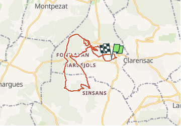
Trail Walking of 17.8 km to be discovered at Occitania, Gard, Saint-Côme-et-Maruéjols. This trail is proposed by v.rabot.

Description

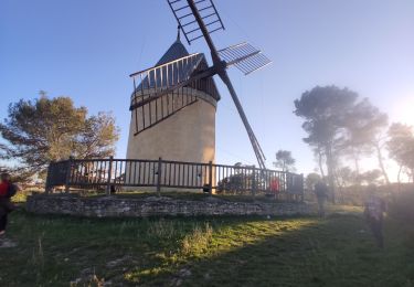
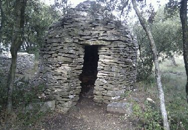
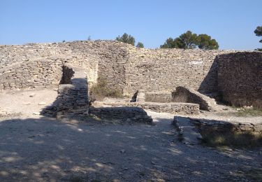
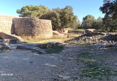
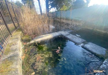
Parking possible près du cimetière et à l'entrée du village, passage sur l'oppidum, présence de capitelles citernes, passage sur le pic Néjean, belles vues sur la plaine, passage à la capitelle du prieuré, à maruejols et apercu sur ses magnifiques propriétés, à la source nombreuses tables de pique-niques, retour par le bois sacré, un nouveau marquage existe et a été suivi, passage dans le village de Saint Come, église, tour de l'horloge, fontaine.

Elevation profile

Photos

Positioning

Country:
France
Region :
Occitania
Department/Province :
Gard
Municipality :
Saint-Côme-et-Maruéjols
Location:
Unknown
Start:(UTM)
596449 ; 4853306 (31T) N.

Trails nearby

Trail Walking Saint-Côme-et-Maruéjols - St côtés et maruejols - Photo
Walking
poisson1103

Walking

Very easy
(1)
Saint-Côme-et-Maruéjols, Occitania, Gard, France
13.8 km | 17.2 km-effort
5h 30min
Yes
Trail Walking Langlade - Langlade - Voie-verte Fontaine - Photo
Walking
rando30129

Walking

Medium
(1)
Langlade, Occitania, Gard, France
7.8 km | 9.1 km-effort
2h 4min
Yes
Trail Mountain bike Calvisson - Espace VTT-FFC Pays de Sommières n°7 - Les Châteaux du Sommiérois - Photo
Mountain bike
tracegps

Mountain bike

Difficult
(1)
Calvisson, Occitania, Gard, France
42 km | 50 km-effort
3h 30min
Yes
Trail Walking Saint-Dionisy - Opidum de Nages - Photo
Walking
CAMBON

Walking

Easy
(2)
Saint-Dionisy, Occitania, Gard, France
6.8 km | 9.4 km-effort
2h 0min
Yes
Trail Walking Nages-et-Solorgues - 30  nages et solorgues langlade - Photo
Walking
GUIDE
randodyssée

Walking

Medium
Nages-et-Solorgues, Occitania, Gard, France
17 km | 22 km-effort
6h 4min
Yes
Trail Walking Langlade - NAGES ET SOLORGUES - LA GRAND COMBE - 16.5Km - 04h30 - Dénivelé 340 m - Photo
Walking
dansmabulle

Walking

Medium
(1)
Langlade, Occitania, Gard, France
16.7 km | 22 km-effort
4h 34min
Yes
Trail Walking Nages-et-Solorgues - nages-langlades - Photo
Walking
v.rabot

Walking

Medium
Nages-et-Solorgues, Occitania, Gard, France
14.8 km | 18.9 km-effort
5h 18min
Yes
Trail Walking Souvignargues - Saint Étienne d’Escattes - Photo
Walking
GUIDE
Roger Philippe Wallez

Walking

Very difficult
Souvignargues, Occitania, Gard, France
16.9 km | 22 km-effort
4h 58min
Yes
Trail Walking Saint-Dionisy - Saint Dionisy -Oppidum - Nages - Photo
Walking
rando30129

Walking

Difficult
(1)
Saint-Dionisy, Occitania, Gard, France
11 km | 15.7 km-effort
3h 9min
Yes


Close
My subscriptions