![](/images/other/stat-length.png)
![Trail Walking Vernègues - Vernègues 21 Mai 2021 - Photo](https://media.geolcdn.com/t/1900/400/95feefb2-9796-40ec-9b8c-a9cdb29699ed.jpg&format=pjpeg&maxdim=2)
Vernègues 21 Mai 2021
ALAPETITE
User
![Length](/images/other/stat-length.png)
Length
10.8 km
![Max alt](https://static1.geolcdn.com/siteimages/upload/files/1508320355ic_sort_altitude_max_24dp.png)
Max alt
385 m
![Uphill gradient](https://static1.geolcdn.com/siteimages/upload/files/1508320355ic_sort_den_pos_24dp.png)
Uphill gradient
256 m
![Km-Effort](/images/other/stat-length.png)
Km-Effort
14.2 km
![Min alt](https://static1.geolcdn.com/siteimages/upload/files/1508320355ic_sort_altitude_min_24dp.png)
Min alt
187 m
![Downhill gradient](https://static1.geolcdn.com/siteimages/upload/files/1508320355ic_sort_den_neg_24dp.png)
Downhill gradient
258 m
![Boucle](https://static1.geolcdn.com/siteimages/upload/files/16400158638029165_repeat_loop_refresh_sync_direction_icon.png)
Boucle
Yes
Creation date :
2021-05-21 11:13:02.319
Updated on :
2021-05-21 14:20:35.411
![Walking](https://static1.geolcdn.com/sitytour/trail-icons/101.png)
2h18
Difficulty : Very easy
![Scan this QR Code to open this trail in the SityTrail application](https://capi.geolives.com/qq0zvz2zws4bq2lad0pu/sitytour/trails/2795254/qr.png?size=200)
FREE GPS app for hiking
About
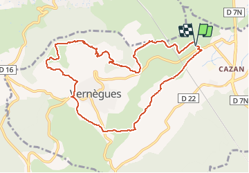
Trail Walking of 10.8 km to be discovered at Provence-Alpes-Côte d'Azur, Bouches-du-Rhône, Vernègues. This trail is proposed by ALAPETITE.
Description
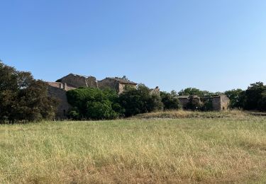
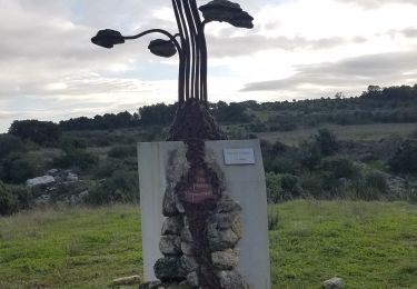
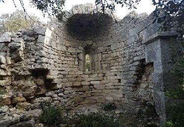
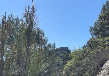
Saint Symphorien, borne milliaire, borie municipale, bassin renversé, point de vue sur le Nord, table orientation, constance, chemin Saint Anne, descente vers Pavillon Victoire, chemin de Vinsargues, Saint Symphorien.
Positioning
Country:
France
Region :
Provence-Alpes-Côte d'Azur
Department/Province :
Bouches-du-Rhône
Municipality :
Vernègues
Location:
Unknown
Start:(Dec)
Start:(UTM)
677072 ; 4840288 (31T) N.
Comments
Trails nearby
![Walking Walking](https://static1.geolcdn.com/sitytour/trail-icons/101.png)
PF-Alleins - Chapelle Saint-Jean - Rousset - Tour Vieille - Vallon de Valcros...
Walking
Easy
(1)
Alleins,
Provence-Alpes-Côte d'Azur,
Bouches-du-Rhône,
France
![](/images/other/stat-length.png)
7.1 km | 9 km-effort
2h 30min
![](https://static1.geolcdn.com/siteimages/upload/files/16400158638029165_repeat_loop_refresh_sync_direction_icon.png)
Yes
![Trail Walking Charleval - PF-Charleval - Les Costes - Bois des Taillades - Cuou de Peyrou - Photo](https://media.geolcdn.com/t/375/260/67a220c4-295b-4d31-b693-d6441f3ed082.jpg&format=jpg&maxdim=2)
![Walking Walking](https://static1.geolcdn.com/sitytour/trail-icons/101.png)
PF-Charleval - Les Costes - Bois des Taillades - Cuou de Peyrou
Walking
Easy
(1)
Charleval,
Provence-Alpes-Côte d'Azur,
Bouches-du-Rhône,
France
![](/images/other/stat-length.png)
5.2 km | 7.2 km-effort
2h 27min
![](https://static1.geolcdn.com/siteimages/upload/files/16400158638029165_repeat_loop_refresh_sync_direction_icon.png)
Yes
![Trail Walking Vernègues - Château bas-Vernègues-chapelle - Photo](https://media.geolcdn.com/t/375/260/9b82dc84-47a8-451b-adac-f7c55291d235.jpg&format=jpg&maxdim=2)
![Walking Walking](https://static1.geolcdn.com/sitytour/trail-icons/101.png)
Château bas-Vernègues-chapelle
Walking
Easy
(3)
Vernègues,
Provence-Alpes-Côte d'Azur,
Bouches-du-Rhône,
France
![](/images/other/stat-length.png)
9.8 km | 12 km-effort
2h 42min
![](https://static1.geolcdn.com/siteimages/upload/files/16400158638029165_repeat_loop_refresh_sync_direction_icon.png)
Yes
![Trail Walking Alleins - Vernegues, St Jean, Rousset, St Georges, Tour Vieille. - Photo](https://media.geolcdn.com/t/375/260/ext.jpg?maxdim=2&url=https%3A%2F%2Fservices.sitytrail.com%2FGeolivesWS%2FDownloadMedia.ashx%3FTrailID%3D696925%26Media%3Dfix__20170212100152.jpg)
![Walking Walking](https://static1.geolcdn.com/sitytour/trail-icons/101.png)
Vernegues, St Jean, Rousset, St Georges, Tour Vieille.
Walking
Very easy
(1)
Alleins,
Provence-Alpes-Côte d'Azur,
Bouches-du-Rhône,
France
![](/images/other/stat-length.png)
8.1 km | 10.4 km-effort
2h 6min
![](https://static1.geolcdn.com/siteimages/upload/files/16400158638029165_repeat_loop_refresh_sync_direction_icon.png)
Yes
![Trail Other activity Aurons - cabanon douceur - Photo](https://media.geolcdn.com/t/375/260/ext.jpg?maxdim=2&url=https%3A%2F%2Fservices.sitytrail.com%2FGeolivesWS%2FDownloadMedia.ashx%3FTrailID%3D568585%26Media%3Dfix__20160512110504.jpg)
![Other activity Other activity](https://static1.geolcdn.com/sitytour/trail-icons/900.png)
cabanon douceur
Other activity
Very easy
(2)
Aurons,
Provence-Alpes-Côte d'Azur,
Bouches-du-Rhône,
France
![](/images/other/stat-length.png)
6.6 km | 8.2 km-effort
3h 4min
![](https://static1.geolcdn.com/siteimages/upload/files/16400158638029165_repeat_loop_refresh_sync_direction_icon.png)
Yes
![Trail Walking Vernègues - PF-Vernègues - Château Bas-Badasset-Vernègues - Photo](https://media.geolcdn.com/t/375/260/ext.jpg?maxdim=2&url=https%3A%2F%2Fservices.sitytrail.com%2FGeolivesWS%2FDownloadMedia.ashx%3FTrailID%3D524378%26Media%3D20160211154541.jpg)
![Walking Walking](https://static1.geolcdn.com/sitytour/trail-icons/101.png)
PF-Vernègues - Château Bas-Badasset-Vernègues
Walking
Easy
(1)
Vernègues,
Provence-Alpes-Côte d'Azur,
Bouches-du-Rhône,
France
![](/images/other/stat-length.png)
7.8 km | 9.7 km-effort
2h 8min
![](https://static1.geolcdn.com/siteimages/upload/files/16400158638029165_repeat_loop_refresh_sync_direction_icon.png)
Yes
![Trail Mountain bike Aurons - Les Deux Bosquets - Photo](https://media.geolcdn.com/t/375/260/ext.jpg?maxdim=2&url=https%3A%2F%2Fservices.sitytrail.com%2FGeolivesWS%2FDownloadMedia.ashx%3FTrailID%3D108560%26Media%3D1468_2.jpg)
![Mountain bike Mountain bike](https://static1.geolcdn.com/sitytour/trail-icons/202.png)
Les Deux Bosquets
Mountain bike
Difficult
(1)
Aurons,
Provence-Alpes-Côte d'Azur,
Bouches-du-Rhône,
France
![](/images/other/stat-length.png)
7.4 km | 9.3 km-effort
2h 0min
![](https://static1.geolcdn.com/siteimages/upload/files/16400158638029165_repeat_loop_refresh_sync_direction_icon.png)
Yes
![Trail Walking Vernègues - PF-Vernègues - Saint Symphorien - Plateau - Saint Jacques - XA - 11.04.2024 - Photo](https://media.geolcdn.com/t/375/260/8f68e661-d95c-42ca-a729-ff91b0c9ff90.jpg&format=jpg&maxdim=2)
![Walking Walking](https://static1.geolcdn.com/sitytour/trail-icons/101.png)
PF-Vernègues - Saint Symphorien - Plateau - Saint Jacques - XA - 11.04.2024
Walking
Difficult
Vernègues,
Provence-Alpes-Côte d'Azur,
Bouches-du-Rhône,
France
![](/images/other/stat-length.png)
10.2 km | 13.5 km-effort
3h 4min
![](https://static1.geolcdn.com/siteimages/upload/files/16400158638029165_repeat_loop_refresh_sync_direction_icon.png)
Yes
![Walking Walking](https://static1.geolcdn.com/sitytour/trail-icons/101.png)
SityTrail - GRvP - De Mallemort à Mérindol
Walking
Easy
Mallemort,
Provence-Alpes-Côte d'Azur,
Bouches-du-Rhône,
France
![](/images/other/stat-length.png)
5.3 km | 6.1 km-effort
1h 30min
![](https://static1.geolcdn.com/siteimages/upload/files/16400158638029165_repeat_loop_refresh_sync_direction_icon.png)
No