![](/images/other/stat-length.png)
20210521 - HUY Totemus 4.6 Km
pierreh01
User GUIDE
![Length](/images/other/stat-length.png)
Length
4.6 km
![Max alt](https://static1.geolcdn.com/siteimages/upload/files/1508320355ic_sort_altitude_max_24dp.png)
Max alt
130 m
![Uphill gradient](https://static1.geolcdn.com/siteimages/upload/files/1508320355ic_sort_den_pos_24dp.png)
Uphill gradient
87 m
![Km-Effort](/images/other/stat-length.png)
Km-Effort
5.7 km
![Min alt](https://static1.geolcdn.com/siteimages/upload/files/1508320355ic_sort_altitude_min_24dp.png)
Min alt
66 m
![Downhill gradient](https://static1.geolcdn.com/siteimages/upload/files/1508320355ic_sort_den_neg_24dp.png)
Downhill gradient
78 m
![Boucle](https://static1.geolcdn.com/siteimages/upload/files/16400158638029165_repeat_loop_refresh_sync_direction_icon.png)
Boucle
Yes
Creation date :
2021-05-21 08:23:28.0
Updated on :
2021-05-21 21:29:34.848
![Walking](https://static1.geolcdn.com/sitytour/trail-icons/101.png)
2h13
Difficulty : Very easy
![Scan this QR Code to open this trail in the SityTrail application](https://capi.geolives.com/qq0zvz2zws4bq2lad0pu/sitytour/trails/2795084/qr.png?size=200)
FREE GPS app for hiking
About
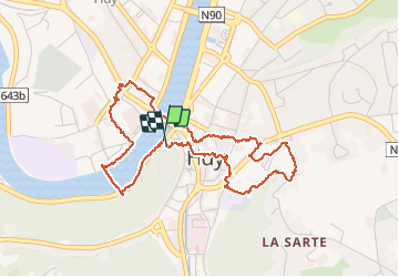
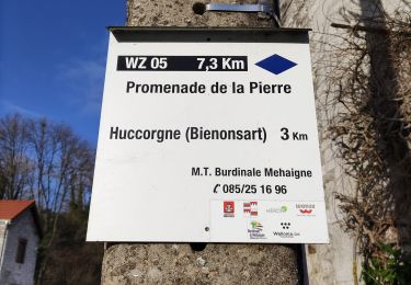
Trail Walking of 4.6 km to be discovered at Wallonia, Liège, Huy. This trail is proposed by pierreh01.
Description
Balade TOTEMUS à la découverte de HUY.
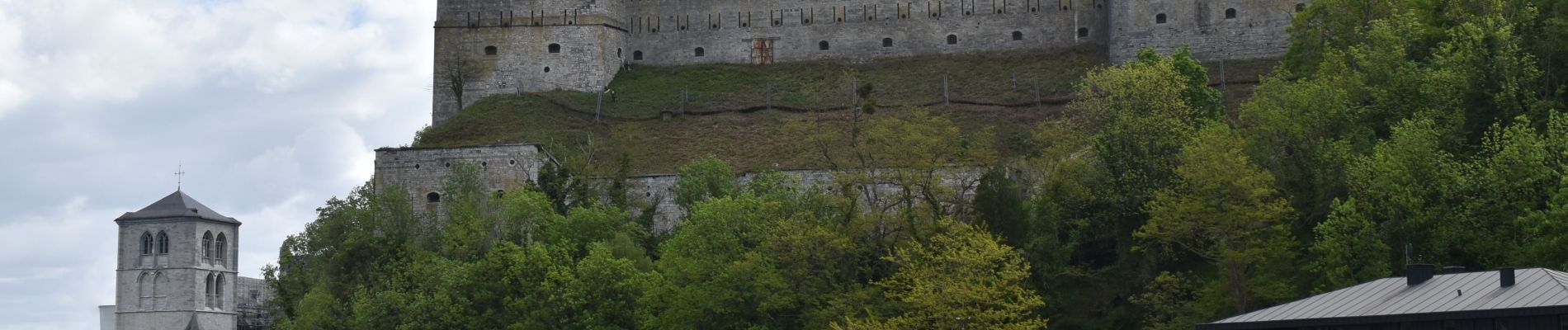
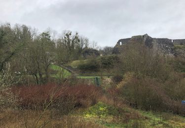
Après cette balade, visite du Fort de HUY.
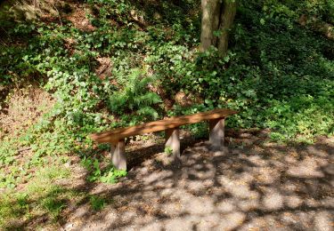
Positioning
Country:
Belgium
Region :
Wallonia
Department/Province :
Liège
Municipality :
Huy
Location:
Unknown
Start:(Dec)
Start:(UTM)
658620 ; 5598714 (31U) N.
Comments
Trails nearby
![Trail Walking Huy - Huy Ben-Ahin. Natura 2000 des sites qui valent le détour ! Lg9 - Photo](https://media.geolcdn.com/t/375/260/ext.jpg?maxdim=2&url=https%3A%2F%2Fservices.sitytrail.com%2FGeolivesWS%2FDownloadMedia.ashx%3FTrailID%3D182987%26Media%3Da8459ff4-9180-431b-88aa-1e326f78de1f.JPG)
![Walking Walking](https://static1.geolcdn.com/sitytour/trail-icons/101.png)
Huy Ben-Ahin. Natura 2000 des sites qui valent le détour ! Lg9
Walking
Medium
(15)
Huy,
Wallonia,
Liège,
Belgium
![](/images/other/stat-length.png)
7.9 km | 10.7 km-effort
2h 18min
![](https://static1.geolcdn.com/siteimages/upload/files/16400158638029165_repeat_loop_refresh_sync_direction_icon.png)
No
![Walking Walking](https://static1.geolcdn.com/sitytour/trail-icons/101.png)
CHHATEAU DE MOHA
Walking
Medium
(2)
Wanze,
Wallonia,
Liège,
Belgium
![](/images/other/stat-length.png)
7.3 km | 9.1 km-effort
1h 58min
![](https://static1.geolcdn.com/siteimages/upload/files/16400158638029165_repeat_loop_refresh_sync_direction_icon.png)
Yes
![Trail Walking Huy - TIHANGE (Temple Tibétain). - Photo](https://media.geolcdn.com/t/375/260/ext.jpg?maxdim=2&url=https%3A%2F%2Fservices.sitytrail.com%2FGeolivesWS%2FDownloadMedia.ashx%3FTrailID%3D458488%26Media%3Dfix__20150813122829.jpg)
![Walking Walking](https://static1.geolcdn.com/sitytour/trail-icons/101.png)
TIHANGE (Temple Tibétain).
Walking
Very easy
(2)
Huy,
Wallonia,
Liège,
Belgium
![](/images/other/stat-length.png)
11.5 km | 13.9 km-effort
3h 1min
![](https://static1.geolcdn.com/siteimages/upload/files/16400158638029165_repeat_loop_refresh_sync_direction_icon.png)
Yes
![Trail Walking Wanze - antheit - Photo](https://media.geolcdn.com/t/375/260/63403872-a8da-4090-b10f-81e240d58ff7.jpg&format=jpg&maxdim=2)
![Walking Walking](https://static1.geolcdn.com/sitytour/trail-icons/101.png)
![Trail Walking Wanze - les long pieds anthey - Photo](https://media.geolcdn.com/t/375/260/04ed0be7-9f2b-4519-ab41-baa0902f0e32.jpg&format=jpg&maxdim=2)
![Walking Walking](https://static1.geolcdn.com/sitytour/trail-icons/101.png)
les long pieds anthey
Walking
Medium
(1)
Wanze,
Wallonia,
Liège,
Belgium
![](/images/other/stat-length.png)
12.9 km | 16 km-effort
2h 34min
![](https://static1.geolcdn.com/siteimages/upload/files/16400158638029165_repeat_loop_refresh_sync_direction_icon.png)
Yes
![Trail Walking Huy - Ben Ahin La Solière - Photo](https://media.geolcdn.com/t/375/260/ext.jpg?maxdim=2&url=https%3A%2F%2Fservices.sitytrail.com%2FGeolivesWS%2FDownloadMedia.ashx%3FTrailID%3D42709%26Media%3Dl)
![Walking Walking](https://static1.geolcdn.com/sitytour/trail-icons/101.png)
Ben Ahin La Solière
Walking
Very easy
(1)
Huy,
Wallonia,
Liège,
Belgium
![](/images/other/stat-length.png)
14.3 km | 19 km-effort
4h 54min
![](https://static1.geolcdn.com/siteimages/upload/files/16400158638029165_repeat_loop_refresh_sync_direction_icon.png)
Yes
![Trail Walking Wanze - Balade de Moha à Huccorgne - Photo](https://media.geolcdn.com/t/375/260/79c0e9b7-562a-4cd6-b98a-d6b2066aed18.jpg&format=jpg&maxdim=2)
![Walking Walking](https://static1.geolcdn.com/sitytour/trail-icons/101.png)
Balade de Moha à Huccorgne
Walking
Difficult
Wanze,
Wallonia,
Liège,
Belgium
![](/images/other/stat-length.png)
9.7 km | 12.2 km-effort
2h 45min
![](https://static1.geolcdn.com/siteimages/upload/files/16400158638029165_repeat_loop_refresh_sync_direction_icon.png)
Yes
![Trail Walking Wanze - Promenade de la pierre à Moha - Photo](https://media.geolcdn.com/t/375/260/3e1d5a0a-9771-4a56-9792-6d76817a97b6.jpg&format=jpg&maxdim=2)
![Walking Walking](https://static1.geolcdn.com/sitytour/trail-icons/101.png)
Promenade de la pierre à Moha
Walking
Medium
(4)
Wanze,
Wallonia,
Liège,
Belgium
![](/images/other/stat-length.png)
7.5 km | 9.2 km-effort
2h 10min
![](https://static1.geolcdn.com/siteimages/upload/files/16400158638029165_repeat_loop_refresh_sync_direction_icon.png)
Yes
![Trail Walking Huy - Le Vallon de la Solières - Photo](https://media.geolcdn.com/t/375/260/65d2a8d6-d502-4481-b1eb-8bc80a021f76.jpg&format=jpg&maxdim=2)
![Walking Walking](https://static1.geolcdn.com/sitytour/trail-icons/101.png)
Le Vallon de la Solières
Walking
Difficult
(3)
Huy,
Wallonia,
Liège,
Belgium
![](/images/other/stat-length.png)
10.2 km | 13.4 km-effort
4h 5min
![](https://static1.geolcdn.com/siteimages/upload/files/16400158638029165_repeat_loop_refresh_sync_direction_icon.png)
Yes