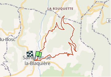
![](/images/other/stat-length.png)
![Trail Nordic walking Saint-Jean-de-la-Blaquière - St Jean de la Blaquière Bois de Latude - Photo](https://media.geolcdn.com/t/1900/400/005eae5c-551e-4e4f-a0bb-75c2b9c56949.jpg&format=pjpeg&maxdim=2)
St Jean de la Blaquière Bois de Latude
mdauzat
User
![Length](/images/other/stat-length.png)
![Max alt](https://static1.geolcdn.com/siteimages/upload/files/1508320355ic_sort_altitude_max_24dp.png)
![Uphill gradient](https://static1.geolcdn.com/siteimages/upload/files/1508320355ic_sort_den_pos_24dp.png)
![Km-Effort](/images/other/stat-length.png)
![Min alt](https://static1.geolcdn.com/siteimages/upload/files/1508320355ic_sort_altitude_min_24dp.png)
![Downhill gradient](https://static1.geolcdn.com/siteimages/upload/files/1508320355ic_sort_den_neg_24dp.png)
![Boucle](https://static1.geolcdn.com/siteimages/upload/files/16400158638029165_repeat_loop_refresh_sync_direction_icon.png)
![Nordic walking](https://static1.geolcdn.com/sitytour/trail-icons/102.png)
2h26
Difficulty : Very easy
![Scan this QR Code to open this trail in the SityTrail application](https://capi.geolives.com/qq0zvz2zws4bq2lad0pu/sitytour/trails/2793006/qr.png?size=200)
FREE GPS app for hiking
About
Trail Nordic walking of 9.7 km to be discovered at Occitania, Hérault, Saint-Jean-de-la-Blaquière. This trail is proposed by mdauzat.
Description
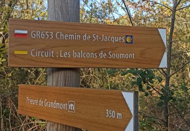
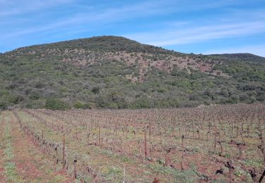
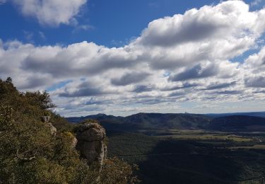
Dans cette deuxième quinzaine d'un moi de mai qui prend des airs de mars, cette belle boucle représente un choix prudent (à noter que les passages à gué ne sont pas praticables en cas de crue). A partir du très beau et très authentique village de Saint-Jean-de-la-Blaquière, le parcours franchit le ruisseau de Sainte-Marguerite, puis, en sentier "monotrace" à travers les vignes à Tourrous, entreprend la montée vers Les Oums. Il franchit, à gué, le ruisseau de La Catarenque et passe sous le plan du Cayla pour rejoindre, sur une large et belle piste forestière, le bois de Latude. C'est alors un cheminement très agréable au cœur de cette très belle forêt, avec de magnifiques points de vue sur toute la plaine, et, notamment, le mont Liausson et le pic de Vissou. La piste redescend ensuite ver Les Costes et Le Bouis, le long des vignes, pour se terminer, à nouveau, par un petit sentier un peu accidenté bordé par de très beaux murs de pierres dressées et revenir au village, qui mérite un petit détour dans les ruelles pour admirer le château, l'église, les beaux murs de pierres et quelques très belles façades.
Positioning
Comments
Trails nearby
![Trail Walking Le Bosc - Saint-Alban - Célis - La Roque - Photo](https://media.geolcdn.com/t/375/260/932d7dea-57ce-4b8a-b586-1c6511489398.jpg&format=jpg&maxdim=2)
![Walking Walking](https://static1.geolcdn.com/sitytour/trail-icons/101.png)
Walking
![](/images/other/stat-length.png)
![](https://static1.geolcdn.com/siteimages/upload/files/16400158638029165_repeat_loop_refresh_sync_direction_icon.png)
![Trail Walking Saint-Saturnin-de-Lucian - Le Rocher des vierges - Photo](https://media.geolcdn.com/t/375/260/ext.jpg?maxdim=2&url=https%3A%2F%2Fservices.sitytrail.com%2FGeolivesWS%2FDownloadMedia.ashx%3FTrailID%3D874639%26Media%3D20171212140026.jpg)
![Walking Walking](https://static1.geolcdn.com/sitytour/trail-icons/101.png)
Walking
![](/images/other/stat-length.png)
![](https://static1.geolcdn.com/siteimages/upload/files/16400158638029165_repeat_loop_refresh_sync_direction_icon.png)
![Trail Walking Le Bosc - Le Bosc - prieuré de Grandmont - Le Brédou - Soumont - Photo](https://media.geolcdn.com/t/375/260/ext.jpg?maxdim=2&url=https%3A%2F%2Fservices.sitytrail.com%2FGeolivesWS%2FDownloadMedia.ashx%3FTrailID%3D384816%26Media%3D8c6417b4-a39d-4b75-b1b0-b5a0d180c222.jpg)
![Walking Walking](https://static1.geolcdn.com/sitytour/trail-icons/101.png)
Walking
![](/images/other/stat-length.png)
![](https://static1.geolcdn.com/siteimages/upload/files/16400158638029165_repeat_loop_refresh_sync_direction_icon.png)
![Trail Walking Saint-Jean-de-la-Blaquière - Les Bois de Homs et de Latude - Photo](https://media.geolcdn.com/t/375/260/ext.jpg?maxdim=2&url=https%3A%2F%2Fstatic1.geolcdn.com%2Fsiteimages%2Fupload%2Ffiles%2F1553511878bg_sport_marche.png)
![Walking Walking](https://static1.geolcdn.com/sitytour/trail-icons/101.png)
Walking
![](/images/other/stat-length.png)
![](https://static1.geolcdn.com/siteimages/upload/files/16400158638029165_repeat_loop_refresh_sync_direction_icon.png)
![Trail sport Saint-Privat - Grand mont Soumont Le Bosc - Photo](https://media.geolcdn.com/t/375/260/644144e6-f45d-4f7c-aed8-e9b8cdd32135.jpg&format=jpg&maxdim=2)
sport
![](/images/other/stat-length.png)
![](https://static1.geolcdn.com/siteimages/upload/files/16400158638029165_repeat_loop_refresh_sync_direction_icon.png)
![Trail Walking Saint-Saturnin-de-Lucian - Le rocher de la vierge - Photo](https://media.geolcdn.com/t/375/260/03375317-134e-4b70-9790-7cfdc2b0601c.jpg&format=jpg&maxdim=2)
![Walking Walking](https://static1.geolcdn.com/sitytour/trail-icons/101.png)
Walking
![](/images/other/stat-length.png)
![](https://static1.geolcdn.com/siteimages/upload/files/16400158638029165_repeat_loop_refresh_sync_direction_icon.png)
![Trail Walking Saint-Privat - Abbaye de Grandmont - Photo](https://media.geolcdn.com/t/375/260/b46b6927-65ec-412a-bc03-c25b367f6012.jpg&format=jpg&maxdim=2)
![Walking Walking](https://static1.geolcdn.com/sitytour/trail-icons/101.png)
Walking
![](/images/other/stat-length.png)
![](https://static1.geolcdn.com/siteimages/upload/files/16400158638029165_repeat_loop_refresh_sync_direction_icon.png)
![Trail Nordic walking Le Bosc - Autour du Ruisseau de Rivernous - Photo](https://media.geolcdn.com/t/375/260/33e565a2-e01e-48b4-a752-f110dd24b31a.jpg&format=jpg&maxdim=2)
![Nordic walking Nordic walking](https://static1.geolcdn.com/sitytour/trail-icons/102.png)
Nordic walking
![](/images/other/stat-length.png)
![](https://static1.geolcdn.com/siteimages/upload/files/16400158638029165_repeat_loop_refresh_sync_direction_icon.png)
![Trail Nordic walking Saint-Saturnin-de-Lucian - Rocher des Vierges de Saint Saturnin - Photo](https://media.geolcdn.com/t/375/260/2ae49080-9941-4051-b193-f34b51b48a57.jpg&format=jpg&maxdim=2)
![Nordic walking Nordic walking](https://static1.geolcdn.com/sitytour/trail-icons/102.png)
Nordic walking
![](/images/other/stat-length.png)
![](https://static1.geolcdn.com/siteimages/upload/files/16400158638029165_repeat_loop_refresh_sync_direction_icon.png)