Trail Road bike Mormoiron - Chalet Reynard  - Photo
© OpenStreetMap contributors
Length
Length
73 km
Max alt
Max alt
1433 m
Uphill gradient
Uphill gradient
1800 m
Km-Effort
Km-Effort  
97 km
Min alt
Min alt
203 m
Downhill gradient
Downhill gradient
1800 m
Boucle
Boucle
Yes
Creation date :
2021-05-19 06:04:46.594
Updated on :
2021-05-19 11:07:38.084

(0 Reviews)

Road bike
Road bike
4h31
Difficulty : Very difficult

Scan this QR Code to open this trail in the SityTrail application

FREE GPS app for hiking

Logo SityTrail SityTrail

IGN / Geographical institutes

Download SityTrail from the App Store Download SityTrail from Google Play

Logo SityTrail SityTrail World

The world is yours!

Download SityTrail from the App Store Download SityTrail from Google Play Download SityTrail on Huawei AppGallery

About

Trail Road bike of 73 km to be discovered at Provence-Alpes-Côte d'Azur, Vaucluse, Mormoiron. This trail is proposed by Jean-Marie Bousquet.

Description

de Mormoiron montée par Bedoin et retour par Salut et le col des Abeilles

Elevation profile

Positioning

Country:
France
Region :
Provence-Alpes-Côte d'Azur
Department/Province :
Vaucluse
Municipality :
Mormoiron
Location:
Unknown
Start:(UTM)
676046 ; 4879605 (31T) N.

Trails nearby

Trail Walking Villes-sur-Auzon - villes sur auzon - Photo
Walking
Vero7684

Walking

Difficult
(1)
Villes-sur-Auzon, Provence-Alpes-Côte d'Azur, Vaucluse, France
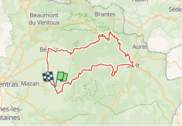
22 km | 31 km-effort
6h 18min
Yes
Trail Walking Malemort-du-Comtat - malemort de Comtat PR19 - Photo
Walking
DoBelle

Walking

Easy
(1)
Malemort-du-Comtat, Provence-Alpes-Côte d'Azur, Vaucluse, France
15.9 km | 20 km-effort
3h 53min
No
Trail Walking Mormoiron - Ballade for Friends - Photo
Walking
GUIDE
supercolas

Walking

Medium
(1)
Mormoiron, Provence-Alpes-Côte d'Azur, Vaucluse, France
7.3 km | 9 km-effort
2h 2min
Yes
Trail Walking Mazan - pierres Sèches Mazan - Photo
Walking
GUIDE
supercolas

Walking

Medium
(1)
Mazan, Provence-Alpes-Côte d'Azur, Vaucluse, France
7.5 km | 10.4 km-effort
2h 33min
Yes
Trail Walking Villes-sur-Auzon - LES ESCAMPEAUX - Photo
Walking
FLORENSAC

Walking

Medium
(1)
Villes-sur-Auzon, Provence-Alpes-Côte d'Azur, Vaucluse, France
14.9 km | 21 km-effort
4h 50min
Yes
Trail Walking Méthamis - De Méthamis au four à chaux par la Gorge de la Nesque - Photo
Walking
tracegps

Walking

Medium
(1)
Méthamis, Provence-Alpes-Côte d'Azur, Vaucluse, France
12.7 km | 16.9 km-effort
4h 30min
Yes
Trail Mountain bike Mormoiron - Valcombe et balcon du Ventoux - Photo
Mountain bike
GUIDE
supercolas

Mountain bike

Medium
Mormoiron, Provence-Alpes-Côte d'Azur, Vaucluse, France
33 km | 41 km-effort
2h 3min
Yes
Trail Walking Mormoiron - Rand'Ocres et Salettes - Photo
Walking
GUIDE
supercolas

Walking

Medium
Mormoiron, Provence-Alpes-Côte d'Azur, Vaucluse, France
10.9 km | 14.6 km-effort
3h 0min
Yes
Trail Walking Mormoiron - Ocres et forêt  - Photo
Walking
GUIDE
supercolas

Walking

Easy
Mormoiron, Provence-Alpes-Côte d'Azur, Vaucluse, France
4.9 km | 6.2 km-effort
1h 8min
Yes


Close
My subscriptions