Trail Walking Unknown - w-ierland-wicklowway - Photo

w-ierland-wicklowway

© OpenStreetMap contributors
Length
Length
129 km
Max alt
Max alt
721 m
Uphill gradient
Uphill gradient
4115 m
Km-Effort
Km-Effort  
184 km
Min alt
Min alt
45 m
Downhill gradient
Downhill gradient
4145 m
Boucle
Boucle
No
Creation date :
2014-12-10 00:00:00.0
Updated on :
2014-12-10 00:00:00.0

(0 Reviews)

Walking
Walking
--
Difficulty : Unknown

Scan this QR Code to open this trail in the SityTrail application

FREE GPS app for hiking

Logo SityTrail SityTrail

IGN / Geographical institutes

Download SityTrail from the App Store Download SityTrail from Google Play

Logo SityTrail SityTrail World

The world is yours!

Download SityTrail from the App Store Download SityTrail from Google Play Download SityTrail on Huawei AppGallery

About

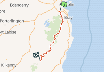
Trail Walking of 129 km to be discovered at Unknown, County Dublin, Unknown. This trail is proposed by gpstracks.

Description

More information on GPStracks.nl : http://www.gpstracks.nl

Elevation profile

Points of interest

Point of interest The Municipal District of Baltinglass - Bridgeland - Photo
gpstracks
THE MUNICIPAL DISTRICT OF BALTINGLASS 
Point of interest The Municipal District of Bray - Diversion to Djouce Mountain N - Photo
gpstracks
THE MUNICIPAL DISTRICT OF BRAY 
Point of interest The Municipal District of Wicklow - Diversion to Djouce Mountain S - Photo
gpstracks
THE MUNICIPAL DISTRICT OF WICKLOW 
Point of interest The Municipal District of Bray - Djouce Mountain - Photo
gpstracks
THE MUNICIPAL DISTRICT OF BRAY 
Point of interest The Municipal District of Arklow - Drumgoff - Photo
gpstracks
THE MUNICIPAL DISTRICT OF ARKLOW 
Point of interest The Municipal District of Baltinglass - Iron Bridge - Photo
gpstracks
THE MUNICIPAL DISTRICT OF BALTINGLASS 
Point of interest The Municipal District of Bray - Knockree - Photo
gpstracks
THE MUNICIPAL DISTRICT OF BRAY 
Point of interest The Municipal District of Wicklow - Laragh - Photo
gpstracks
THE MUNICIPAL DISTRICT OF WICKLOW 
Point of interest The Municipal District of Wicklow - Lough Tay - Photo
gpstracks
THE MUNICIPAL DISTRICT OF WICKLOW 
Point of interest The Municipal District of Baltinglass - Raheenakit - Photo
gpstracks
THE MUNICIPAL DISTRICT OF BALTINGLASS 
Point of interest The Municipal District of Tullow - Start/finish Clonegal - Photo
gpstracks
THE MUNICIPAL DISTRICT OF TULLOW 
Point of interest Unknown - Start/finish Marlay Park - Photo
gpstracks

Positioning

Country:
Ireland
Region :
Unknown
Department/Province :
County Dublin
Municipality :
Unknown
Location:
Whitechurch ED
Start:(UTM)
682120 ; 5906609 (29U) N.

Trails nearby

Trail Running Unknown - Ticknock WL route 2014 - Photo
Running
mickhanney

Running

Difficult
Unknown, Unknown, Unknown, Ireland
8.2 km | 12.5 km-effort
Unknown
No
Trail Other activity Unknown - Fairy Chase - Photo
Other activity
bradygerry

Other activity

Very easy
Unknown, Unknown, Unknown, Ireland
6.2 km | 9.5 km-effort
Unknown
Yes
Trail sport Unknown - Recorded on 9/29/22 4:10 PM - Photo
sport
appreview

sport

Very easy
Unknown, Unknown, Unknown, Ireland
24 m | 24 m-effort
Unknown
No


Close
My subscriptions