Trail Walking Perros-Guirec - w-frankrijk-de-roze-granietkust-van-ploumanach - Photo

w-frankrijk-de-roze-granietkust-van-ploumanach

© OpenStreetMap contributors
Length
Length
8.9 km
Max alt
Max alt
66 m
Uphill gradient
Uphill gradient
119 m
Km-Effort
Km-Effort  
10.5 km
Min alt
Min alt
3 m
Downhill gradient
Downhill gradient
132 m
Boucle
Boucle
No
Creation date :
2014-12-10 00:00:00.0
Updated on :
2014-12-10 00:00:00.0

(1 Reviews)

Walking
Walking
--
Difficulty : Unknown

Scan this QR Code to open this trail in the SityTrail application

FREE GPS app for hiking

Logo SityTrail SityTrail

IGN / Geographical institutes

Download SityTrail from the App Store Download SityTrail from Google Play

Logo SityTrail SityTrail World

The world is yours!

Download SityTrail from the App Store Download SityTrail from Google Play Download SityTrail on Huawei AppGallery

About

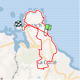
Trail Walking of 8.9 km to be discovered at Brittany, Côtes-d'Armor, Perros-Guirec. This trail is proposed by gpstracks.

Description

More information on GPStracks.nl : http://www.gpstracks.nl

Elevation profile

Points of interest

Point of interest Perros-Guirec - Camping - Photo
gpstracks
PERROS-GUIREC 
Point of interest Perros-Guirec - Kael La Clarté - Photo
gpstracks
PERROS-GUIREC 
Point of interest Perros-Guirec - Maison Littoral - Photo
gpstracks
PERROS-GUIREC 
Point of interest Perros-Guirec - Moulin Du Crac - Photo
gpstracks
PERROS-GUIREC 
Point of interest Perros-Guirec - Parkeerplaats - Photo
gpstracks
PERROS-GUIREC 
Point of interest Perros-Guirec - Picnicplek met bankje - Photo
gpstracks
PERROS-GUIREC 
Point of interest Perros-Guirec - Picnicplek met bankje 2 - Photo
gpstracks
Point of interest Perros-Guirec - Station reddingsboot - Photo
gpstracks
PERROS-GUIREC 
Point of interest Perros-Guirec - Strandje - Photo
gpstracks
PERROS-GUIREC 

Positioning

Country:
France
Region :
Brittany
Department/Province :
Côtes-d'Armor
Municipality :
Perros-Guirec
Location:
Unknown
Start:(UTM)
465111 ; 5408492 (30U) N.

Comments

Please log in to post a review or rate the element


Trails nearby

Trail Walking Perros-Guirec - Perros-Guirec - GR34 - 11.1km 185m 2h50 - 2023 09 08 - Photo
Walking
GUIDE
Orcal37

Walking

Medium
(1)
Perros-Guirec, Brittany, Côtes-d'Armor, France
11.1 km | 13.6 km-effort
2h 50min
Yes
Trail Walking Trégastel - Trégastel - GR34 Île Renote Moulin à marée Chapelle de Gorgon - 13.8km 100m 3h35 - 2023 09 07 - Photo
Walking
GUIDE
Orcal37

Walking

Difficult
(2)
Trégastel, Brittany, Côtes-d'Armor, France
13.8 km | 15.1 km-effort
3h 35min
Yes
Trail Walking Perros-Guirec - la côte de granit rose à Ploumanach - Photo
Walking
GUIDE
amiral13

Walking

Very easy
(2)
Perros-Guirec, Brittany, Côtes-d'Armor, France
6 km | 6.9 km-effort
2h 38min
Yes
Trail Walking Perros-Guirec - Les sentiers de Ploumanac'h - Photo
Walking
tracegps

Walking

Medium
(2)
Perros-Guirec, Brittany, Côtes-d'Armor, France
10.3 km | 12 km-effort
3h 0min
Yes
Trail Walking Louannec - Louannec - GR34 PR - 11.5km 185m 3h00 (40mn) - 2023 09 14 - Photo
Walking
GUIDE
Orcal37

Walking

Difficult
Louannec, Brittany, Côtes-d'Armor, France
11.5 km | 13.9 km-effort
3h 0min
Yes
Trail Walking Trégastel - Trégastel - GR34 Ploumanac'h Kasino de Perros-Guirec - 11.7km 200m 2h55 (50mn) - 2023 09 08 - Photo
Walking
GUIDE
Orcal37

Walking

Medium
Trégastel, Brittany, Côtes-d'Armor, France
11.7 km | 14.4 km-effort
2h 55min
Yes
Trail Walking Pleumeur-Bodou - Pleumeur-Bodou - GR34 Chapelle Saint-Samson - 7.7km 60m 1h55 - 2023 09 06 - Photo
Walking
GUIDE
Orcal37

Walking

Medium
Pleumeur-Bodou, Brittany, Côtes-d'Armor, France
7.7 km | 8.5 km-effort
1h 55min
Yes
Trail Bicycle tourism Pleumeur-Bodou - Landrellec à kercoz - Photo
Bicycle tourism
GUIDE
nadd73

Bicycle tourism

Easy
Pleumeur-Bodou, Brittany, Côtes-d'Armor, France
52 km | 61 km-effort
4h 19min
No
Trail Walking Trégastel - GR34-EtapeIII-J05 - Photo
Walking
JMCMoreau

Walking

Easy
(1)
Trégastel, Brittany, Côtes-d'Armor, France
19.2 km | 21 km-effort
6h 30min
No


Close
My subscriptions