![](/images/other/stat-length.png)
ITILAR066V51O4DC
jeromelacoste
User
![Length](/images/other/stat-length.png)
Length
6.8 km
![Max alt](https://static1.geolcdn.com/siteimages/upload/files/1508320355ic_sort_altitude_max_24dp.png)
Max alt
136 m
![Uphill gradient](https://static1.geolcdn.com/siteimages/upload/files/1508320355ic_sort_den_pos_24dp.png)
Uphill gradient
132 m
![Km-Effort](/images/other/stat-length.png)
Km-Effort
8.7 km
![Min alt](https://static1.geolcdn.com/siteimages/upload/files/1508320355ic_sort_altitude_min_24dp.png)
Min alt
16 m
![Downhill gradient](https://static1.geolcdn.com/siteimages/upload/files/1508320355ic_sort_den_neg_24dp.png)
Downhill gradient
176 m
![Boucle](https://static1.geolcdn.com/siteimages/upload/files/16400158638029165_repeat_loop_refresh_sync_direction_icon.png)
Boucle
No
Creation date :
2021-05-10 16:45:22.031
Updated on :
2021-05-10 16:58:15.943
![Walking](https://static1.geolcdn.com/sitytour/trail-icons/101.png)
1h30
Difficulty : Easy
![Scan this QR Code to open this trail in the SityTrail application](https://capi.geolives.com/qq0zvz2zws4bq2lad0pu/sitytour/trails/2781165/qr.png?size=200)
FREE GPS app for hiking
About
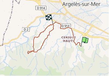
Trail Walking of 6.8 km to be discovered at Occitania, Pyrénées-Orientales, Argelès-sur-Mer. This trail is proposed by jeromelacoste.
Description
L’une des plus belles balades de notre commune ravissante en tout point par ses paysages, sa petite ascension vers l’ermitage
Notre-Dame de vie et sa chapelle St-Jérôme d’où le point de vue est magnifique.
Positioning
Country:
France
Region :
Occitania
Department/Province :
Pyrénées-Orientales
Municipality :
Argelès-sur-Mer
Location:
Unknown
Start:(Dec)
Start:(UTM)
502447 ; 4708755 (31T) N.
Comments
Trails nearby
![Trail Mountain bike Argelès-sur-Mer - la dujardin - Photo](https://media.geolcdn.com/t/375/260/ext.jpg?maxdim=2&url=https%3A%2F%2Fservices.sitytrail.com%2FGeolivesWS%2FDownloadMedia.ashx%3FTrailID%3D244823%26Media%3Dfix__20140126110534.jpg)
![Mountain bike Mountain bike](https://static1.geolcdn.com/sitytour/trail-icons/202.png)
la dujardin
Mountain bike
Very easy
(5)
Argelès-sur-Mer,
Occitania,
Pyrénées-Orientales,
France
![](/images/other/stat-length.png)
11.6 km | 18.7 km-effort
1h 11min
![](https://static1.geolcdn.com/siteimages/upload/files/16400158638029165_repeat_loop_refresh_sync_direction_icon.png)
No
![Trail Walking Collioure - Collioure-le racou - Photo](https://media.geolcdn.com/t/375/260/4f99edd2-3783-4586-a076-7bfd0caed82a.jpg&format=jpg&maxdim=2)
![Walking Walking](https://static1.geolcdn.com/sitytour/trail-icons/101.png)
Collioure-le racou
Walking
Medium
(2)
Collioure,
Occitania,
Pyrénées-Orientales,
France
![](/images/other/stat-length.png)
7.2 km | 9.3 km-effort
2h 1min
![](https://static1.geolcdn.com/siteimages/upload/files/16400158638029165_repeat_loop_refresh_sync_direction_icon.png)
Yes
![Trail Walking Argelès-sur-Mer - 66 ARGELES SUR MER - mas Christine, promenade dans les Albères, par les pistes,sentiers, entre les chênes lièges - Photo](https://media.geolcdn.com/t/375/260/ext.jpg?maxdim=2&url=https%3A%2F%2Fservices.sitytrail.com%2FGeolivesWS%2FDownloadMedia.ashx%3FTrailID%3D493707%26Media%3D20151114095454.jpg)
![Walking Walking](https://static1.geolcdn.com/sitytour/trail-icons/101.png)
66 ARGELES SUR MER - mas Christine, promenade dans les Albères, par les piste...
Walking
Medium
(2)
Argelès-sur-Mer,
Occitania,
Pyrénées-Orientales,
France
![](/images/other/stat-length.png)
7.4 km | 9.8 km-effort
1h 28min
![](https://static1.geolcdn.com/siteimages/upload/files/16400158638029165_repeat_loop_refresh_sync_direction_icon.png)
Yes
![Trail Walking Collioure - 66 COLLIOURE - les balcons de Madeloc - circuit de la tour et des fortifications - Photo](https://media.geolcdn.com/t/375/260/ext.jpg?maxdim=2&url=https%3A%2F%2Fservices.sitytrail.com%2FGeolivesWS%2FDownloadMedia.ashx%3FTrailID%3D465811%26Media%3D20150829101927.jpg)
![Walking Walking](https://static1.geolcdn.com/sitytour/trail-icons/101.png)
66 COLLIOURE - les balcons de Madeloc - circuit de la tour et des fortificati...
Walking
Difficult
(1)
Collioure,
Occitania,
Pyrénées-Orientales,
France
![](/images/other/stat-length.png)
9.3 km | 14.9 km-effort
2h 4min
![](https://static1.geolcdn.com/siteimages/upload/files/16400158638029165_repeat_loop_refresh_sync_direction_icon.png)
Yes
![Trail Walking Saint-André - 66 SAINT-ANDRE - SOREDE - chapelle Saint Ferreol de la Pava - Photo](https://media.geolcdn.com/t/375/260/ext.jpg?maxdim=2&url=https%3A%2F%2Fservices.sitytrail.com%2FGeolivesWS%2FDownloadMedia.ashx%3FTrailID%3D455673%26Media%3D20150807175253.jpg)
![Walking Walking](https://static1.geolcdn.com/sitytour/trail-icons/101.png)
66 SAINT-ANDRE - SOREDE - chapelle Saint Ferreol de la Pava
Walking
Medium
(1)
Saint-André,
Occitania,
Pyrénées-Orientales,
France
![](/images/other/stat-length.png)
14.2 km | 16.9 km-effort
2h 25min
![](https://static1.geolcdn.com/siteimages/upload/files/16400158638029165_repeat_loop_refresh_sync_direction_icon.png)
Yes
![Trail Walking Argelès-sur-Mer - ARGELES SUR MER 66 - VALMY - tour de la Massane - les Colomates - Photo](https://media.geolcdn.com/t/375/260/ext.jpg?maxdim=2&url=https%3A%2F%2Fservices.sitytrail.com%2FGeolivesWS%2FDownloadMedia.ashx%3FTrailID%3D440893%26Media%3D20150704091656.jpg)
![Walking Walking](https://static1.geolcdn.com/sitytour/trail-icons/101.png)
ARGELES SUR MER 66 - VALMY - tour de la Massane - les Colomates
Walking
Difficult
(2)
Argelès-sur-Mer,
Occitania,
Pyrénées-Orientales,
France
![](/images/other/stat-length.png)
22 km | 34 km-effort
5h 35min
![](https://static1.geolcdn.com/siteimages/upload/files/16400158638029165_repeat_loop_refresh_sync_direction_icon.png)
Yes
![Trail Walking Collioure - COLLIOURE 66 - Ermitage ND de consolation - tour MADELOC - Photo](https://media.geolcdn.com/t/375/260/ext.jpg?maxdim=2&url=https%3A%2F%2Fservices.sitytrail.com%2FGeolivesWS%2FDownloadMedia.ashx%3FTrailID%3D417631%26Media%3D20150507185238.jpg)
![Walking Walking](https://static1.geolcdn.com/sitytour/trail-icons/101.png)
COLLIOURE 66 - Ermitage ND de consolation - tour MADELOC
Walking
Difficult
(4)
Collioure,
Occitania,
Pyrénées-Orientales,
France
![](/images/other/stat-length.png)
14.7 km | 23 km-effort
3h 41min
![](https://static1.geolcdn.com/siteimages/upload/files/16400158638029165_repeat_loop_refresh_sync_direction_icon.png)
Yes
![Trail Walking Argelès-sur-Mer - Racou- Colioure 06-2014 - Photo](https://media.geolcdn.com/t/375/260/ext.jpg?maxdim=2&url=https%3A%2F%2Fservices.sitytrail.com%2FGeolivesWS%2FDownloadMedia.ashx%3FTrailID%3D315155%26Media%3Dfix__20140617164009.jpg)
![Walking Walking](https://static1.geolcdn.com/sitytour/trail-icons/101.png)
Racou- Colioure 06-2014
Walking
Very easy
(1)
Argelès-sur-Mer,
Occitania,
Pyrénées-Orientales,
France
![](/images/other/stat-length.png)
5 km | 6.5 km-effort
1h 36min
![](https://static1.geolcdn.com/siteimages/upload/files/16400158638029165_repeat_loop_refresh_sync_direction_icon.png)
No
![Trail Walking Argelès-sur-Mer - 66 ARGELES SUR MER, ARGELES PLAGE, par les traverses et retour par le front de mer et le village - Photo](https://media.geolcdn.com/t/375/260/ext.jpg?maxdim=2&url=https%3A%2F%2Fservices.sitytrail.com%2FGeolivesWS%2FDownloadMedia.ashx%3FTrailID%3D488322%26Media%3D20151030173410.jpg)
![Walking Walking](https://static1.geolcdn.com/sitytour/trail-icons/101.png)
66 ARGELES SUR MER, ARGELES PLAGE, par les traverses et retour par le front d...
Walking
Easy
(2)
Argelès-sur-Mer,
Occitania,
Pyrénées-Orientales,
France
![](/images/other/stat-length.png)
8.9 km | 9.5 km-effort
1h 29min
![](https://static1.geolcdn.com/siteimages/upload/files/16400158638029165_repeat_loop_refresh_sync_direction_icon.png)
Yes