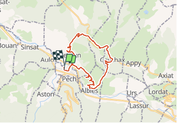
![](/images/other/stat-length.png)
![Trail Walking Les Cabannes - del'Ariègeàlacorniche - Photo](https://media.geolcdn.com/t/1900/400/ext.pjpeg?maxdim=2&url=https%3A%2F%2Fstatic1.geolcdn.com%2Fsiteimages%2Fupload%2Ffiles%2F1553511878bg_sport_marche.png)
del'Ariègeàlacorniche
annehc
User
![Length](/images/other/stat-length.png)
Length
15.4 km
![Max alt](https://static1.geolcdn.com/siteimages/upload/files/1508320355ic_sort_altitude_max_24dp.png)
Max alt
963 m
![Uphill gradient](https://static1.geolcdn.com/siteimages/upload/files/1508320355ic_sort_den_pos_24dp.png)
Uphill gradient
707 m
![Km-Effort](/images/other/stat-length.png)
Km-Effort
25 km
![Min alt](https://static1.geolcdn.com/siteimages/upload/files/1508320355ic_sort_altitude_min_24dp.png)
Min alt
525 m
![Downhill gradient](https://static1.geolcdn.com/siteimages/upload/files/1508320355ic_sort_den_neg_24dp.png)
Downhill gradient
715 m
![Boucle](https://static1.geolcdn.com/siteimages/upload/files/16400158638029165_repeat_loop_refresh_sync_direction_icon.png)
Boucle
Yes
Creation date :
2021-05-04 07:34:59.77
Updated on :
2021-05-04 15:51:57.635
![Walking](https://static1.geolcdn.com/sitytour/trail-icons/101.png)
5h42
Difficulty : Very difficult
![Scan this QR Code to open this trail in the SityTrail application](https://capi.geolives.com/qq0zvz2zws4bq2lad0pu/sitytour/trails/2773205/qr.png?size=200)
FREE GPS app for hiking
About
Trail Walking of 15.4 km to be discovered at Occitania, Ariège, Les Cabannes. This trail is proposed by annehc.
Description
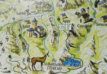
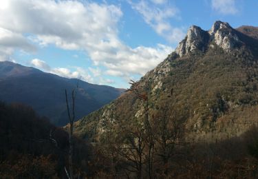
vallées d'Ax d'un village à l'autre n°6 ermitage de st pierre
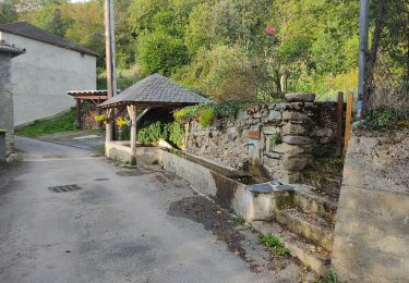
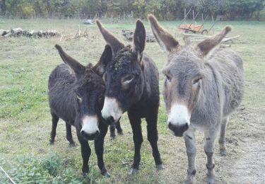
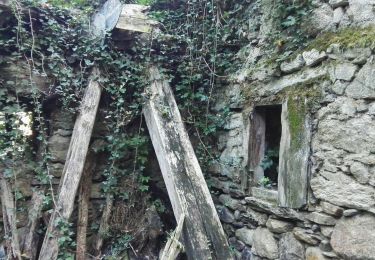
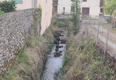
4 mai 2022 : première rando du séjour à Les Cabanes
au départ du gîte
9 personnes (3 hommes et 6 femmes)
Positioning
Country:
France
Region :
Occitania
Department/Province :
Ariège
Municipality :
Les Cabannes
Location:
Unknown
Start:(Dec)
Start:(UTM)
392456 ; 4738024 (31T) N.
Comments
Trails nearby
![Trail Walking Vèbre - rocher de Courbas - Photo](https://media.geolcdn.com/t/375/260/78ac6878-cdb8-4ec7-b32a-125e834666e2.jpg&format=jpg&maxdim=2)
![Walking Walking](https://static1.geolcdn.com/sitytour/trail-icons/101.png)
![Trail Walking Larnat - Cap de la Lesse - Photo](https://media.geolcdn.com/t/375/260/92ac1c0a-3485-447b-b2e9-0e186b2c8c4a.jpg&format=jpg&maxdim=2)
![Walking Walking](https://static1.geolcdn.com/sitytour/trail-icons/101.png)
![Trail Walking Verdun - Verdun, Albies, Vebre - Photo](https://media.geolcdn.com/t/375/260/09d31640-9aa3-44e2-9378-d3fce780c5e7.jpg&format=jpg&maxdim=2)
![Walking Walking](https://static1.geolcdn.com/sitytour/trail-icons/101.png)
Verdun, Albies, Vebre
Walking
Easy
Verdun,
Occitania,
Ariège,
France
![](/images/other/stat-length.png)
4.4 km | 6 km-effort
1h 33min
![](https://static1.geolcdn.com/siteimages/upload/files/16400158638029165_repeat_loop_refresh_sync_direction_icon.png)
No
![Trail Walking Vèbre - Vebre, Lassure, La Remise, Vebre - Photo](https://media.geolcdn.com/t/375/260/cf162537-37a8-4720-813f-495781f6b81b.jpg&format=jpg&maxdim=2)
![Walking Walking](https://static1.geolcdn.com/sitytour/trail-icons/101.png)
Vebre, Lassure, La Remise, Vebre
Walking
Easy
Vèbre,
Occitania,
Ariège,
France
![](/images/other/stat-length.png)
8.1 km | 12.6 km-effort
2h 34min
![](https://static1.geolcdn.com/siteimages/upload/files/16400158638029165_repeat_loop_refresh_sync_direction_icon.png)
Yes
![Trail Walking Vèbre - Vebre, Caychax. Alliés, Vebre - Photo](https://media.geolcdn.com/t/375/260/f0774cf6-f888-497f-b6e0-9780e9ab44f4.jpg&format=jpg&maxdim=2)
![Walking Walking](https://static1.geolcdn.com/sitytour/trail-icons/101.png)
Vebre, Caychax. Alliés, Vebre
Walking
Easy
Vèbre,
Occitania,
Ariège,
France
![](/images/other/stat-length.png)
9.6 km | 15.1 km-effort
2h 53min
![](https://static1.geolcdn.com/siteimages/upload/files/16400158638029165_repeat_loop_refresh_sync_direction_icon.png)
No
![Trail Walking Larnat - Col de Larnat et Col Doulent - Photo](https://media.geolcdn.com/t/375/260/ext.jpg?maxdim=2&url=https%3A%2F%2Fstatic1.geolcdn.com%2Fsiteimages%2Fupload%2Ffiles%2F1553511878bg_sport_marche.png)
![Walking Walking](https://static1.geolcdn.com/sitytour/trail-icons/101.png)
Col de Larnat et Col Doulent
Walking
Difficult
(1)
Larnat,
Occitania,
Ariège,
France
![](/images/other/stat-length.png)
14.8 km | 23 km-effort
4h 42min
![](https://static1.geolcdn.com/siteimages/upload/files/16400158638029165_repeat_loop_refresh_sync_direction_icon.png)
Yes
![Trail Walking Les Cabannes - Camina des Cabannes à Luzenac - Photo](https://media.geolcdn.com/t/375/260/769278fe-4b2d-46e7-8dc9-a102db4840ed.jpg&format=jpg&maxdim=2)
![Walking Walking](https://static1.geolcdn.com/sitytour/trail-icons/101.png)
Camina des Cabannes à Luzenac
Walking
Easy
Les Cabannes,
Occitania,
Ariège,
France
![](/images/other/stat-length.png)
8.4 km | 10.6 km-effort
2h 46min
![](https://static1.geolcdn.com/siteimages/upload/files/16400158638029165_repeat_loop_refresh_sync_direction_icon.png)
No
![Trail Walking Appy - Etang d'Appy - Photo](https://media.geolcdn.com/t/375/260/ext.jpg?maxdim=2&url=https%3A%2F%2Fstatic1.geolcdn.com%2Fsiteimages%2Fupload%2Ffiles%2F1553511878bg_sport_marche.png)
![Walking Walking](https://static1.geolcdn.com/sitytour/trail-icons/101.png)
![Trail Walking Les Cabannes - chemin des Tuliers n°6 - Photo](https://media.geolcdn.com/t/375/260/ext.jpg?maxdim=2&url=https%3A%2F%2Fservices.sitytrail.com%2FGeolivesWS%2FDownloadMedia.ashx%3FTrailID%3D1081471%26Media%3Dfix__20181206114916.jpg)
![Walking Walking](https://static1.geolcdn.com/sitytour/trail-icons/101.png)
chemin des Tuliers n°6
Walking
Easy
Les Cabannes,
Occitania,
Ariège,
France
![](/images/other/stat-length.png)
14.1 km | 21 km-effort
4h 30min
![](https://static1.geolcdn.com/siteimages/upload/files/16400158638029165_repeat_loop_refresh_sync_direction_icon.png)
Yes