Trail On foot Saint-Vallier-de-Thiey - Circuit de la Carrière de Marbre . - Photo
© OpenStreetMap contributors
Length
Length
7 km
Max alt
Max alt
1088 m
Uphill gradient
Uphill gradient
371 m
Km-Effort
Km-Effort  
11.9 km
Min alt
Min alt
715 m
Downhill gradient
Downhill gradient
371 m
Boucle
Boucle
Yes
Creation date :
2021-05-01 14:27:54.241
Updated on :
2021-05-01 14:36:53.228

(0 Reviews)

On foot
On foot
2h42
Difficulty : Easy

Scan this QR Code to open this trail in the SityTrail application

FREE GPS app for hiking

Logo SityTrail SityTrail

IGN / Geographical institutes

Download SityTrail from the App Store Download SityTrail from Google Play

Logo SityTrail SityTrail World

The world is yours!

Download SityTrail from the App Store Download SityTrail from Google Play Download SityTrail on Huawei AppGallery

About

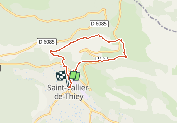
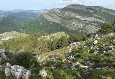
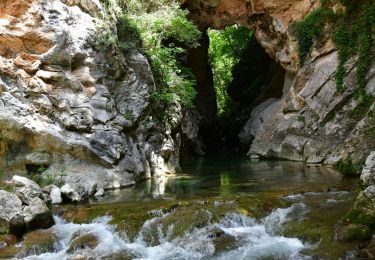
Trail On foot of 7 km to be discovered at Provence-Alpes-Côte d'Azur, Maritime Alps, Saint-Vallier-de-Thiey. This trail is proposed by santaflor.

Description

Un circuit qui surplombe le joli village de Saint- Vallier de Thiey ,dans le 06, avec vue panoramique sur les alentours.

Elevation profile

Positioning

Country:
France
Region :
Provence-Alpes-Côte d'Azur
Department/Province :
Maritime Alps
Municipality :
Saint-Vallier-de-Thiey
Location:
Unknown
Start:(UTM)
326574 ; 4840797 (32T) N.

Trails nearby

Trail Walking Caussols - Le Haut Montet 1335m, Plateau de Caussols - Photo
Walking
tracegps

Walking

Easy
(1)
Caussols, Provence-Alpes-Côte d'Azur, Maritime Alps, France
13.5 km | 18.6 km-effort
4h 0min
Yes
Trail Walking Saint-Vallier-de-Thiey - Arche de Ponadieu Source de la Pare Baou Mourine Vieux Pont  - Photo
Walking
GUIDE
jouans

Walking

Very difficult
Saint-Vallier-de-Thiey, Provence-Alpes-Côte d'Azur, Maritime Alps, France
19.2 km | 32 km-effort
7h 20min
Yes
Trail On foot Caussols - Plateau de Caussols - Photo
On foot
GUIDE+

On foot

Easy
Caussols, Provence-Alpes-Côte d'Azur, Maritime Alps, France
13.9 km | 19.1 km-effort
4h 20min
Yes
Trail On foot Escragnolles - Plateau de Briasq - Photo
On foot
GUIDE+

On foot

Medium
Escragnolles, Provence-Alpes-Côte d'Azur, Maritime Alps, France
14.1 km | 22 km-effort
4h 56min
Yes
Trail Walking Caussols - La Meute Plateau de Caussols 3 - Photo
Walking
DIDIERLESERT

Walking

Medium
(1)
Caussols, Provence-Alpes-Côte d'Azur, Maritime Alps, France
12.4 km | 17.2 km-effort
4h 0min
Yes
Trail Walking Saint-Vallier-de-Thiey - Grasse - Montagne de Thiey - Photo
Walking
GUIDE
Orcal37

Walking

Medium
Saint-Vallier-de-Thiey, Provence-Alpes-Côte d'Azur, Maritime Alps, France
14.9 km | 25 km-effort
4h 54min
Yes
Trail Walking Caussols - La Meute Plateau de Caussols - Photo
Walking
DIDIERLESERT

Walking

Medium
(1)
Caussols, Provence-Alpes-Côte d'Azur, Maritime Alps, France
14.9 km | 20 km-effort
4h 17min
Yes
Trail Walking Saint-Vallier-de-Thiey - St Vallier : Colle du  maçon doublier  - Photo
Walking
ETMU5496

Walking

Difficult
Saint-Vallier-de-Thiey, Provence-Alpes-Côte d'Azur, Maritime Alps, France
18.2 km | 29 km-effort
6h 35min
Yes
Trail Walking Saint-Vallier-de-Thiey - St Vallier de Thiey - Col de la Lèque - Chapelle St Jean - Arche Ponadieu - Photo
Walking
LtZIP

Walking

Medium
Saint-Vallier-de-Thiey, Provence-Alpes-Côte d'Azur, Maritime Alps, France
14.1 km | 21 km-effort
4h 44min
Yes


Close
My subscriptions