![](/images/other/stat-length.png)
![Trail Walking Olne - Balade 10 de Olne - Photo](https://media.geolcdn.com/t/1900/400/6c8246a0-c9b5-48f6-93f5-5d8324119f6a.jpg&format=pjpeg&maxdim=2)
Balade 10 de Olne
amyrose
User
![Length](/images/other/stat-length.png)
Length
7.8 km
![Max alt](https://static1.geolcdn.com/siteimages/upload/files/1508320355ic_sort_altitude_max_24dp.png)
Max alt
245 m
![Uphill gradient](https://static1.geolcdn.com/siteimages/upload/files/1508320355ic_sort_den_pos_24dp.png)
Uphill gradient
213 m
![Km-Effort](/images/other/stat-length.png)
Km-Effort
10.6 km
![Min alt](https://static1.geolcdn.com/siteimages/upload/files/1508320355ic_sort_altitude_min_24dp.png)
Min alt
116 m
![Downhill gradient](https://static1.geolcdn.com/siteimages/upload/files/1508320355ic_sort_den_neg_24dp.png)
Downhill gradient
208 m
![Boucle](https://static1.geolcdn.com/siteimages/upload/files/16400158638029165_repeat_loop_refresh_sync_direction_icon.png)
Boucle
Yes
Creation date :
2021-04-30 12:22:24.0
Updated on :
2021-05-02 13:41:25.952
![Walking](https://static1.geolcdn.com/sitytour/trail-icons/101.png)
2h26
Difficulty : Medium
![Scan this QR Code to open this trail in the SityTrail application](https://capi.geolives.com/qq0zvz2zws4bq2lad0pu/sitytour/trails/2767498/qr.png?size=200)
FREE GPS app for hiking
About
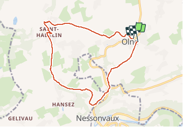
Trail Walking of 7.8 km to be discovered at Wallonia, Liège, Olne. This trail is proposed by amyrose.
Description
c'est la croix verte
Olne village se diriger vers saint Hadelin par le tilleui descendre vers le fief remonter à la croix Renard descendre Chinehotte
à Nessonvaux aller vers Tonvoie Pt Vaux Gd Vaux remonter à Olne par les prés et les échaliers ressortir par le patro et chez Warnier
Positioning
Country:
Belgium
Region :
Wallonia
Department/Province :
Liège
Municipality :
Olne
Location:
Olne
Start:(Dec)
Start:(UTM)
694579 ; 5607914 (31U) N.
Comments
Trails nearby
![Trail Walking Pepinster - RB-Lg-23_Soiron_via-racc-2 - Photo](https://media.geolcdn.com/t/375/260/ext.jpg?maxdim=2&url=https%3A%2F%2Fservices.sitytrail.com%2FGeolivesWS%2FDownloadMedia.ashx%3FTrailID%3D400856%26Media%3D1646b7fd-8650-448d-bc3d-5efa9ed8c932.jpg)
![Walking Walking](https://static1.geolcdn.com/sitytour/trail-icons/101.png)
RB-Lg-23_Soiron_via-racc-2
Walking
(8)
Pepinster,
Wallonia,
Liège,
Belgium
![](/images/other/stat-length.png)
13.4 km | 17.5 km-effort
3h 58min
![](https://static1.geolcdn.com/siteimages/upload/files/16400158638029165_repeat_loop_refresh_sync_direction_icon.png)
Yes
![Trail Walking Pepinster - RB-Lg-23_Soiron - Photo](https://media.geolcdn.com/t/375/260/ext.jpg?maxdim=2&url=https%3A%2F%2Fservices.sitytrail.com%2FGeolivesWS%2FDownloadMedia.ashx%3FTrailID%3D400853%26Media%3D1646b7fd-8650-448d-bc3d-5efa9ed8c932.jpg)
![Walking Walking](https://static1.geolcdn.com/sitytour/trail-icons/101.png)
![Trail Walking Trooz - RB-Lg-03 - Entre Vesdre et Hoëgne - Photo](https://media.geolcdn.com/t/375/260/ext.jpg?maxdim=2&url=https%3A%2F%2Fservices.sitytrail.com%2FGeolivesWS%2FDownloadMedia.ashx%3FTrailID%3D179559%26Media%3Dcef2de81-7d4f-4fcd-9e9d-f315370fe61f.jpg)
![Walking Walking](https://static1.geolcdn.com/sitytour/trail-icons/101.png)
RB-Lg-03 - Entre Vesdre et Hoëgne
Walking
Medium
(12)
Trooz,
Wallonia,
Liège,
Belgium
![](/images/other/stat-length.png)
22 km | 29 km-effort
6h 9min
![](https://static1.geolcdn.com/siteimages/upload/files/16400158638029165_repeat_loop_refresh_sync_direction_icon.png)
Yes
![Trail Walking Fléron - 2024-06-16_18h18m53_1402.gpx.xml - Photo](https://media.geolcdn.com/t/375/260/65875cd7-f353-4090-b6ef-a8656311fae6.jpg&format=jpg&maxdim=2)
![Walking Walking](https://static1.geolcdn.com/sitytour/trail-icons/101.png)
2024-06-16_18h18m53_1402.gpx.xml
Walking
Medium
(1)
Fléron,
Wallonia,
Liège,
Belgium
![](/images/other/stat-length.png)
9.8 km | 12.3 km-effort
2h 47min
![](https://static1.geolcdn.com/siteimages/upload/files/16400158638029165_repeat_loop_refresh_sync_direction_icon.png)
Yes
![Trail Walking Pepinster - 2022-05-13_11h44m22_Cirkwi-Soiron_6___Tribomont,_Wegnez - Photo](https://media.geolcdn.com/t/375/260/ec8c930a-9871-4566-956d-2a2016034199.jpg&format=jpg&maxdim=2)
![Walking Walking](https://static1.geolcdn.com/sitytour/trail-icons/101.png)
2022-05-13_11h44m22_Cirkwi-Soiron_6___Tribomont,_Wegnez
Walking
Easy
(1)
Pepinster,
Wallonia,
Liège,
Belgium
![](/images/other/stat-length.png)
9.5 km | 12.5 km-effort
2h 50min
![](https://static1.geolcdn.com/siteimages/upload/files/16400158638029165_repeat_loop_refresh_sync_direction_icon.png)
Yes
![Walking Walking](https://static1.geolcdn.com/sitytour/trail-icons/101.png)
20220307 - Saint-Hadelin 8.8 Km
Walking
Medium
(1)
Olne,
Wallonia,
Liège,
Belgium
![](/images/other/stat-length.png)
8.4 km | 10.9 km-effort
2h 24min
![](https://static1.geolcdn.com/siteimages/upload/files/16400158638029165_repeat_loop_refresh_sync_direction_icon.png)
Yes
![Trail Walking Trooz - 2022-02-03_17h57m35_BaladedeFraipont - Photo](https://media.geolcdn.com/t/375/260/a22be754-a7d6-4ac7-b88b-6e30a6735908.jpg&format=jpg&maxdim=2)
![Walking Walking](https://static1.geolcdn.com/sitytour/trail-icons/101.png)
2022-02-03_17h57m35_BaladedeFraipont
Walking
Medium
(1)
Trooz,
Wallonia,
Liège,
Belgium
![](/images/other/stat-length.png)
12.3 km | 17.3 km-effort
3h 55min
![](https://static1.geolcdn.com/siteimages/upload/files/16400158638029165_repeat_loop_refresh_sync_direction_icon.png)
Yes
![Trail Walking Trooz - 2021-05-16_08h02m48_1403 - Photo](https://media.geolcdn.com/t/375/260/d573d865-936c-49e5-ac73-8dda0a954532.jpg&format=jpg&maxdim=2)
![Walking Walking](https://static1.geolcdn.com/sitytour/trail-icons/101.png)
2021-05-16_08h02m48_1403
Walking
Difficult
(1)
Trooz,
Wallonia,
Liège,
Belgium
![](/images/other/stat-length.png)
10.1 km | 14.6 km-effort
3h 19min
![](https://static1.geolcdn.com/siteimages/upload/files/16400158638029165_repeat_loop_refresh_sync_direction_icon.png)
Yes
![Trail Walking Olne - 2021-03-10_16h10m11_1409 - Photo](https://media.geolcdn.com/t/375/260/8c16a020-3972-4fd4-95a4-e68b814bf4ee.jpg&format=jpg&maxdim=2)
![Walking Walking](https://static1.geolcdn.com/sitytour/trail-icons/101.png)
2021-03-10_16h10m11_1409
Walking
Medium
(3)
Olne,
Wallonia,
Liège,
Belgium
![](/images/other/stat-length.png)
11.7 km | 16.1 km-effort
3h 39min
![](https://static1.geolcdn.com/siteimages/upload/files/16400158638029165_repeat_loop_refresh_sync_direction_icon.png)
Yes