boucle marchaisiere / la boutelaie / le marchais/plaineffe SityTrail > Trails > Outdoor > France > Centre-Loire Valley > Indre > Langé SityTrail > Trails > Outdoor > France > Centre-Loire Valley > Indre > Langé boucle marchaisiere / la boutelaie / le marchais/plaineffe Gwen Bonneau User 3D © OpenStreetMap contributors Length 7.2 km Max alt 186 m Uphill gradient 61 m Km-Effort 8 km Min alt 152 m Downhill gradient 65 m Boucle No Creation date : 2021-04-30 08:41:23.581 Updated on : 2021-04-30 10:09:09.887 (0 Reviews) Horseback riding 1h02 Difficulty : Easy FREE GPS app for hiking SityTrail IGN / Geographical institutes SityTrail World The world is yours! About Trail Horseback riding of 7.2 km to be discovered at Centre-Loire Valley, Indre, Langé. This trail is proposed by Gwen Bonneau. Legends | More details (PDF) Elevation profile Legends > 15% 15% - 10% 10% - 5% flat 5% - 10% 10% - 15% 15% - 30% > 30% Positioning Country: France Region : Centre-Loire Valley Department/Province : Indre Municipality : Langé Location: Unknown Start:(Dec) 47.0669892244041 / 1.4698182698339224 Start:(UTM) 383814 ; 5213744 (31T) N. Comments Please log in to post a review or rate the element Trails nearby 2433e59 Viocq , Valancey Walking Very easy Vicq-sur-Nahon, Centre-Loire Valley, Indre, France 
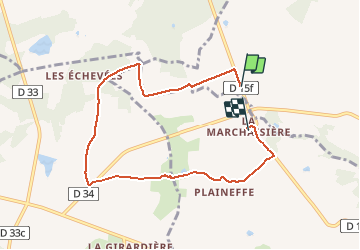
12.5 km | 14.4 km-effort 3h 19min No annehc La Foulquetière - Le Puits de Saray Walking Very difficult Luçay-le-Mâle, Centre-Loire Valley, Indre, France 25 km | 28 km-effort 5h 15min No Fredrando64 Randonnée - boucle jaune - Géhée On foot Easy Gehée, Centre-Loire Valley, Indre, France 10.5 km | 12.1 km-effort 2h 45min Yes Fredrando64 Randonnée - boucle bleue - Géhée On foot Easy Gehée, Centre-Loire Valley, Indre, France 5.2 km | 6.2 km-effort 1h 30min Yes Glurps Sob 14 moulins/cephons St pierre de lamps sport Very easy Moulins-sur-Céphons, Centre-Loire Valley, Indre, France 6 km | 6.6 km-effort Unknown No