Trail On foot Souspierre - jabron/Souspierre Bridon - Photo

jabron/Souspierre Bridon

 drogerys
drogerys

User

© OpenStreetMap contributors
Length
Length
11.3 km
Max alt
Max alt
457 m
Uphill gradient
Uphill gradient
325 m
Km-Effort
Km-Effort  
15.6 km
Min alt
Min alt
238 m
Downhill gradient
Downhill gradient
307 m
Boucle
Boucle
No
Creation date :
2021-04-27 17:42:06.611
Updated on :
2021-04-27 20:11:47.514

(0 Reviews)

On foot
On foot
3h32
Difficulty : Easy

Scan this QR Code to open this trail in the SityTrail application

FREE GPS app for hiking

Logo SityTrail SityTrail

IGN / Geographical institutes

Download SityTrail from the App Store Download SityTrail from Google Play

Logo SityTrail SityTrail World

The world is yours!

Download SityTrail from the App Store Download SityTrail from Google Play Download SityTrail on Huawei AppGallery

About

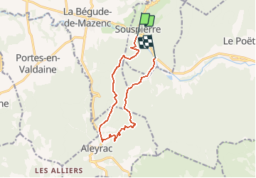
Trail On foot of 11.3 km to be discovered at Auvergne-Rhône-Alpes, Drôme, Souspierre. This trail is proposed by drogerys.

Description

Départ du pont au-dessus du Jabron en face du Jas (D 540) vers Combremont. Prendre de suite et tout droit le sentier vers "La barre de fer" Passer sous "Serre Buffet", puis la "Crête des Monges", "La grande Pigne". Rejoindre le GR de Pays passant sous "Serre du pommier" jusqu'à "Grange neuve" et le carrefour avec la route d'Aleyrac. Prendre à gauche la route de "Chabotte" passer à "Bouvet", puis Cazal. Prendre le sentier tout droit au-dessus de la "Grande Combe"et descendre le "Ravin de font froide", "La fontaine des Monges", le "Ruisseau de Chabotte" et enfin le Bridon, au bord du Jabron.

Elevation profile

Positioning

Country:
France
Region :
Auvergne-Rhône-Alpes
Department/Province :
Drôme
Municipality :
Souspierre
Location:
Unknown
Start:(UTM)
655650 ; 4933533 (31T) N.

Trails nearby

Trail On foot Eyzahut - SityTrail - Boucle 1 - Photo
On foot
Julie LABBE

On foot

Very difficult
(2)
Eyzahut, Auvergne-Rhône-Alpes, Drôme, France
17.3 km | 31 km-effort
6h 0min
Yes
Trail Walking Portes-en-Valdaine - GPX-Rando-Plaine-Portoise-nouvelleversion - Photo
Walking
GUIDE
thonyc

Walking

Easy
(1)
Portes-en-Valdaine, Auvergne-Rhône-Alpes, Drôme, France
7.1 km | 8.2 km-effort
2h 0min
Yes
Trail Walking Portes-en-Valdaine - Portes-en-Valdaine Serre-de-Mirabel 11km. - Photo
Walking
chancha

Walking

Difficult
(1)
Portes-en-Valdaine, Auvergne-Rhône-Alpes, Drôme, France
10.8 km | 14.7 km-effort
3h 20min
Yes
Trail Walking Portes-en-Valdaine - 26 portes en valdaine - Photo
Walking
GUIDE
randodyssée

Walking

Very easy
Portes-en-Valdaine, Auvergne-Rhône-Alpes, Drôme, France
10.6 km | 14.5 km-effort
4h 10min
Yes
Trail Walking Aleyrac - 26 autour aleyrac - Photo
Walking
GUIDE
randodyssée

Walking

Easy
Aleyrac, Auvergne-Rhône-Alpes, Drôme, France
12.4 km | 15.7 km-effort
4h 50min
No
Trail Walking Le Poët-Laval - Le poët laval - Photo
Walking
orlandiniluc

Walking

Medium
(1)
Le Poët-Laval, Auvergne-Rhône-Alpes, Drôme, France
9.8 km | 17.8 km-effort
4h 21min
Yes
Trail Walking Le Poët-Laval - le Poët-Laval et le trou du furet - Photo
Walking
GUIDE
amiral13

Walking

Very easy
Le Poët-Laval, Auvergne-Rhône-Alpes, Drôme, France
7.5 km | 14.3 km-effort
4h 3min
Yes
Trail Walking La Bégude-de-Mazenc - La Bégude de Mazenc - Serre de Forillon - Photo
Walking
tracegps

Walking

Medium
(1)
La Bégude-de-Mazenc, Auvergne-Rhône-Alpes, Drôme, France
8.1 km | 12 km-effort
2h 30min
Yes
Trail Cycle La Bégude-de-Mazenc - La Roche St Secret - Photo
Cycle
tracegps

Cycle

Medium
(1)
La Bégude-de-Mazenc, Auvergne-Rhône-Alpes, Drôme, France
46 km | 56 km-effort
2h 10min
Yes


Close
My subscriptions