![](/images/other/stat-length.png)
![Trail On foot Jardin - Jardin - 9,6 km - 223 m de dénivelé - 3h - Photo](https://media.geolcdn.com/t/1900/400/ext.pjpeg?maxdim=2&url=https%3A%2F%2Fstatic1.geolcdn.com%2Fsiteimages%2Fupload%2Ffiles%2F1545311037marcheuse_200dpi.jpg)
Jardin - 9,6 km - 223 m de dénivelé - 3h
Clubléorando
User
![Length](/images/other/stat-length.png)
Length
9.6 km
![Max alt](https://static1.geolcdn.com/siteimages/upload/files/1508320355ic_sort_altitude_max_24dp.png)
Max alt
409 m
![Uphill gradient](https://static1.geolcdn.com/siteimages/upload/files/1508320355ic_sort_den_pos_24dp.png)
Uphill gradient
223 m
![Km-Effort](/images/other/stat-length.png)
Km-Effort
12.6 km
![Min alt](https://static1.geolcdn.com/siteimages/upload/files/1508320355ic_sort_altitude_min_24dp.png)
Min alt
274 m
![Downhill gradient](https://static1.geolcdn.com/siteimages/upload/files/1508320355ic_sort_den_neg_24dp.png)
Downhill gradient
222 m
![Boucle](https://static1.geolcdn.com/siteimages/upload/files/16400158638029165_repeat_loop_refresh_sync_direction_icon.png)
Boucle
Yes
Creation date :
2021-04-25 17:22:33.852
Updated on :
2021-04-25 17:28:20.287
![On foot](https://static1.geolcdn.com/sitytour/trail-icons/100.png)
3h00
Difficulty : Easy
![Scan this QR Code to open this trail in the SityTrail application](https://capi.geolives.com/qq0zvz2zws4bq2lad0pu/sitytour/trails/2762389/qr.png?size=200)
FREE GPS app for hiking
About
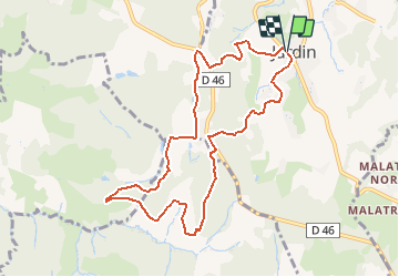
Trail On foot of 9.6 km to be discovered at Auvergne-Rhône-Alpes, Isère, Jardin. This trail is proposed by Clubléorando.
Description
Ballade en boucle au départ de jardin puis montée en direction du Télégraphe et passer au hameau de la Ronze. Retour par le hameau de le Ferrat
Positioning
Country:
France
Region :
Auvergne-Rhône-Alpes
Department/Province :
Isère
Municipality :
Jardin
Location:
Unknown
Start:(Dec)
Start:(UTM)
648977 ; 5039855 (31T) N.
Comments
Trails nearby
![Trail On foot Saint-Sorlin-de-Vienne - St Sorlin - chapelle St Michel - 8,3 km - 154 m de dénivelé - 2h30 - Photo](https://media.geolcdn.com/t/375/260/ext.jpg?maxdim=2&url=https%3A%2F%2Fstatic1.geolcdn.com%2Fsiteimages%2Fupload%2Ffiles%2F1545311037marcheuse_200dpi.jpg)
![On foot On foot](https://static1.geolcdn.com/sitytour/trail-icons/100.png)
St Sorlin - chapelle St Michel - 8,3 km - 154 m de dénivelé - 2h30
On foot
Easy
(1)
Saint-Sorlin-de-Vienne,
Auvergne-Rhône-Alpes,
Isère,
France
![](/images/other/stat-length.png)
8.3 km | 10.4 km-effort
2h 30min
![](https://static1.geolcdn.com/siteimages/upload/files/16400158638029165_repeat_loop_refresh_sync_direction_icon.png)
Yes
![Trail On foot Jardin - Jardin - 10,7 km - 255 m de dénivelé - 3h30 - Photo](https://media.geolcdn.com/t/375/260/ext.jpg?maxdim=2&url=https%3A%2F%2Fstatic1.geolcdn.com%2Fsiteimages%2Fupload%2Ffiles%2F1545311037marcheuse_200dpi.jpg)
![On foot On foot](https://static1.geolcdn.com/sitytour/trail-icons/100.png)
Jardin - 10,7 km - 255 m de dénivelé - 3h30
On foot
Medium
(1)
Jardin,
Auvergne-Rhône-Alpes,
Isère,
France
![](/images/other/stat-length.png)
10.7 km | 14.1 km-effort
3h 30min
![](https://static1.geolcdn.com/siteimages/upload/files/16400158638029165_repeat_loop_refresh_sync_direction_icon.png)
Yes
![Trail Mountain bike Les Côtes-d'Arey - Autour des Cotes d'Arey - Photo](https://media.geolcdn.com/t/375/260/ext.jpg?maxdim=2&url=https%3A%2F%2Fstatic1.geolcdn.com%2Fsiteimages%2Fupload%2Ffiles%2F1524743154velo.jpg)
![Mountain bike Mountain bike](https://static1.geolcdn.com/sitytour/trail-icons/202.png)
Autour des Cotes d'Arey
Mountain bike
Difficult
(2)
Les Côtes-d'Arey,
Auvergne-Rhône-Alpes,
Isère,
France
![](/images/other/stat-length.png)
20 km | 26 km-effort
Unknown
![](https://static1.geolcdn.com/siteimages/upload/files/16400158638029165_repeat_loop_refresh_sync_direction_icon.png)
Yes
![Trail Walking Vienne - naïade nocturne digestive à Vienne - Isère - Photo](https://media.geolcdn.com/t/375/260/3e0ddf70-00b3-4de3-8743-20a20b07d4cf.jpg&format=jpg&maxdim=2)
![Walking Walking](https://static1.geolcdn.com/sitytour/trail-icons/101.png)
naïade nocturne digestive à Vienne - Isère
Walking
Very easy
Vienne,
Auvergne-Rhône-Alpes,
Isère,
France
![](/images/other/stat-length.png)
3 km | 3.6 km-effort
1h 38min
![](https://static1.geolcdn.com/siteimages/upload/files/16400158638029165_repeat_loop_refresh_sync_direction_icon.png)
Yes
![Trail Walking Vienne - 38-Vienne-visite-4.5km-mai21 - Photo](https://media.geolcdn.com/t/375/260/15a6f21e-b5a5-4e05-9520-6ac715530426.jpg&format=jpg&maxdim=2)
![Walking Walking](https://static1.geolcdn.com/sitytour/trail-icons/101.png)
38-Vienne-visite-4.5km-mai21
Walking
Easy
Vienne,
Auvergne-Rhône-Alpes,
Isère,
France
![](/images/other/stat-length.png)
4.6 km | 5.2 km-effort
1h 47min
![](https://static1.geolcdn.com/siteimages/upload/files/16400158638029165_repeat_loop_refresh_sync_direction_icon.png)
Yes
![Trail Cycle Vienne - Via Rhona : Vienne St Rambert d'Albon - Photo](https://media.geolcdn.com/t/375/260/ext.jpg?maxdim=2&url=https%3A%2F%2Fstatic1.geolcdn.com%2Fsiteimages%2Fupload%2Ffiles%2F1524743154velo.jpg)
![Cycle Cycle](https://static1.geolcdn.com/sitytour/trail-icons/200.png)
Via Rhona : Vienne St Rambert d'Albon
Cycle
Very easy
(1)
Vienne,
Auvergne-Rhône-Alpes,
Isère,
France
![](/images/other/stat-length.png)
36 km | 39 km-effort
Unknown
![](https://static1.geolcdn.com/siteimages/upload/files/16400158638029165_repeat_loop_refresh_sync_direction_icon.png)
No
![Trail Walking Vienne - 2023-10-08 - St Alban les Vignes - La Balme - Les Barres - Photo](https://media.geolcdn.com/t/375/260/0b9277b6-2ded-4d19-a426-204d6aa7e481.jpg&format=jpg&maxdim=2)
![Walking Walking](https://static1.geolcdn.com/sitytour/trail-icons/101.png)
2023-10-08 - St Alban les Vignes - La Balme - Les Barres
Walking
Easy
Vienne,
Auvergne-Rhône-Alpes,
Isère,
France
![](/images/other/stat-length.png)
16.4 km | 24 km-effort
4h 53min
![](https://static1.geolcdn.com/siteimages/upload/files/16400158638029165_repeat_loop_refresh_sync_direction_icon.png)
Yes
![Trail Road bike Pont-Évêque - Pont-Évêque 47km - Photo](https://media.geolcdn.com/t/375/260/f6a8b920-25cb-431a-8ca0-51204302ebe0.jpeg&format=jpg&maxdim=2)
![Road bike Road bike](https://static1.geolcdn.com/sitytour/trail-icons/201.png)
Pont-Évêque 47km
Road bike
Very difficult
Pont-Évêque,
Auvergne-Rhône-Alpes,
Isère,
France
![](/images/other/stat-length.png)
47 km | 56 km-effort
3h 23min
![](https://static1.geolcdn.com/siteimages/upload/files/16400158638029165_repeat_loop_refresh_sync_direction_icon.png)
Yes
![Trail On foot Vienne - Vossères - Croix des Chasseurs - fixme - Photo](https://media.geolcdn.com/t/375/260/ext.jpg?maxdim=2&url=https%3A%2F%2Fstatic1.geolcdn.com%2Fsiteimages%2Fupload%2Ffiles%2F1545311037marcheuse_200dpi.jpg)
![On foot On foot](https://static1.geolcdn.com/sitytour/trail-icons/100.png)
Vossères - Croix des Chasseurs - fixme
On foot
Easy
Vienne,
Auvergne-Rhône-Alpes,
Isère,
France
![](/images/other/stat-length.png)
4.4 km | 5.5 km-effort
1h 15min
![](https://static1.geolcdn.com/siteimages/upload/files/16400158638029165_repeat_loop_refresh_sync_direction_icon.png)
No