11.1 km | 16.6 km-effort
Fréland - Col du Wettstein
duchaine.nicolas
User
Length
57 km
Max alt
918 m
Uphill gradient
1613 m
Km-Effort
79 km
Min alt
316 m
Downhill gradient
1614 m
Boucle
Yes
Creation date :
2021-04-25 08:51:46.695
Updated on :
2021-04-26 05:26:24.043
4h39
Difficulty : Medium
4h39
Difficulty : Medium
FREE GPS app for hiking
About
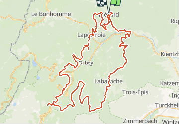
Trail Mountain bike of 57 km to be discovered at Grand Est, Haut-Rhin, Fréland. This trail is proposed by duchaine.nicolas.
Description
Via le Limbach - Herrenwasen - Labaroche - Les 2 Hohnack - Retour par Pairis - Orbey - Remomont - Chamont
Positioning
Country:
France
Region :
Grand Est
Department/Province :
Haut-Rhin
Municipality :
Fréland
Location:
Unknown
Start:(Dec)
Start:(UTM)
365793 ; 5337179 (32U) N.
Comments
Trails nearby
2012-06-16 Marche aux Alisiers Orbey
Walking
Easy
(2)
Lapoutroie,
Grand Est,
Haut-Rhin,
France
2h 49min
Yes
Du ⛺️ aux 4 villages
Walking
Medium
Kaysersberg-Vignoble,
Grand Est,
Haut-Rhin,
France
12.9 km | 15.1 km-effort
3h 30min
Yes
2021-05-30 Marche Kaysersberg Ursprung St Alexis
Walking
Very difficult
Kaysersberg-Vignoble,
Grand Est,
Haut-Rhin,
France
17.1 km | 26 km-effort
4h 46min
Yes
2019-11-03 WE Aubure Taennchel
Horseback riding
Very easy
Aubure,
Grand Est,
Haut-Rhin,
France
27 km | 41 km-effort
7h 45min
Yes
2019-11-02 WE Aubure Brezouard
Horseback riding
Very easy
Aubure,
Grand Est,
Haut-Rhin,
France
25 km | 39 km-effort
5h 57min
Yes
2019-10-26 CDTE67 Tournage Video Promotion TE
Horseback riding
Easy
Kaysersberg-Vignoble,
Grand Est,
Haut-Rhin,
France
24 km | 29 km-effort
24min
No
Le tour de Kysersberg
Walking
Medium
(1)
Kaysersberg-Vignoble,
Grand Est,
Haut-Rhin,
France
7.9 km | 11.7 km-effort
2h 34min
Yes
2024-07-24_18h02m57_230112363
Walking
Difficult
Lapoutroie,
Grand Est,
Haut-Rhin,
France
10.3 km | 17.2 km-effort
3h 54min
Yes
De Kaysersberg à l'auberge St Alexis
Walking
Difficult
Kaysersberg-Vignoble,
Grand Est,
Haut-Rhin,
France
11.9 km | 18.8 km-effort
4h 15min
Yes