Trail On foot Le Tholonet - 13 Le Tholonet  barrage Zola par gr pays , JS JR RR - Photo

13 Le Tholonet barrage Zola par gr pays , JS JR RR

© OpenStreetMap contributors
Length
Length
13.5 km
Max alt
Max alt
360 m
Uphill gradient
Uphill gradient
433 m
Km-Effort
Km-Effort  
19.2 km
Min alt
Min alt
191 m
Downhill gradient
Downhill gradient
435 m
Boucle
Boucle
Yes
Creation date :
2021-04-24 13:38:10.929
Updated on :
2021-04-24 13:52:48.188

(0 Reviews)

On foot
On foot
4h22
Difficulty : Easy

Scan this QR Code to open this trail in the SityTrail application

FREE GPS app for hiking

Logo SityTrail SityTrail

IGN / Geographical institutes

Download SityTrail from the App Store Download SityTrail from Google Play

Logo SityTrail SityTrail World

The world is yours!

Download SityTrail from the App Store Download SityTrail from Google Play Download SityTrail on Huawei AppGallery

About

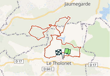
Trail On foot of 13.5 km to be discovered at Provence-Alpes-Côte d'Azur, Bouches-du-Rhône, Le Tholonet. This trail is proposed by jeanneruols.

Description

les Infernets  Lieu dit Les Provences et retour barrage romain  aprés avoir longé le Grand Prignon rando reprise par Jacques

Elevation profile

Positioning

Country:
France
Region :
Provence-Alpes-Côte d'Azur
Department/Province :
Bouches-du-Rhône
Municipality :
Le Tholonet
Location:
Unknown
Start:(UTM)
703223 ; 4822055 (31T) N.

Trails nearby

Trail Walking Aix-en-Provence - Circuit des lacs Zola et Bimont - Aix-en-Provence - Photo
Walking
tracegps

Walking

Medium
(4)
Aix-en-Provence, Provence-Alpes-Côte d'Azur, Bouches-du-Rhône, France
10 km | 13.6 km-effort
2h 30min
Yes
Trail Walking Saint-Marc-Jaumegarde - Barrages Zola-Bimont - Photo
Walking
Berpav

Walking

Medium
(2)
Saint-Marc-Jaumegarde, Provence-Alpes-Côte d'Azur, Bouches-du-Rhône, France
8 km | 11 km-effort
2h 30min
Yes
Trail Walking Saint-Marc-Jaumegarde - La Croix de Provence depuis le barrage de Bimont - Photo
Walking
tracegps

Walking

Difficult
(1)
Saint-Marc-Jaumegarde, Provence-Alpes-Côte d'Azur, Bouches-du-Rhône, France
13.9 km | 24 km-effort
4h 45min
Yes
Trail Walking Saint-Marc-Jaumegarde - Randonnée des crêtes au départ du barrage de Bimont  - Photo
Walking
GUIDE
dudu42

Walking

Medium
Saint-Marc-Jaumegarde, Provence-Alpes-Côte d'Azur, Bouches-du-Rhône, France
6.4 km | 10.4 km-effort
2h 6min
Yes
Trail Walking Aix-en-Provence - Randonnée des barrages Zola et Bimont - Photo
Walking
GUIDE
dudu42

Walking

Medium
Aix-en-Provence, Provence-Alpes-Côte d'Azur, Bouches-du-Rhône, France
10.4 km | 14 km-effort
2h 22min
Yes
Trail Walking Le Tholonet - Le Tholonet -La Croix de Provence Par les Lacs Zola et Bimont - Photo
Walking
GUIDE
donda

Walking

Very difficult
Le Tholonet, Provence-Alpes-Côte d'Azur, Bouches-du-Rhône, France
21 km | 34 km-effort
6h 17min
Yes
Trail On foot Beaurecueil - Sentier Imoucha - Photo
On foot
GUIDE+

On foot

Easy
Beaurecueil, Provence-Alpes-Côte d'Azur, Bouches-du-Rhône, France
4.4 km | 10.1 km-effort
2h 17min
No
Trail Walking Le Tholonet - Bibemus - Lac Zola 1-1-21 - Photo
Walking
GUIDE
fredetpascale

Walking

Medium
(1)
Le Tholonet, Provence-Alpes-Côte d'Azur, Bouches-du-Rhône, France
7.6 km | 10.4 km-effort
2h 21min
No
Trail Walking Aix-en-Provence - Aix - Tour César 8/11/2020 - Photo
Walking
GUIDE
fredetpascale

Walking

Easy
(1)
Aix-en-Provence, Provence-Alpes-Côte d'Azur, Bouches-du-Rhône, France
15.6 km | 19.6 km-effort
3h 26min
Yes


Close
My subscriptions