Trail Walking Potangis - Boucle Potangis Le Perre Chantemerle Bethon - Photo

Boucle Potangis Le Perre Chantemerle Bethon

 NANE51
NANE51

User

© OpenStreetMap contributors
Length
Length
16.4 km
Max alt
Max alt
200 m
Uphill gradient
Uphill gradient
246 m
Km-Effort
Km-Effort  
19.6 km
Min alt
Min alt
73 m
Downhill gradient
Downhill gradient
247 m
Boucle
Boucle
Yes
Creation date :
2021-04-24 09:12:32.0
Updated on :
2021-04-24 13:13:44.287

(0 Reviews)

Walking
Walking
3h33
Difficulty : Easy

Scan this QR Code to open this trail in the SityTrail application

FREE GPS app for hiking

Logo SityTrail SityTrail

IGN / Geographical institutes

Download SityTrail from the App Store Download SityTrail from Google Play

Logo SityTrail SityTrail World

The world is yours!

Download SityTrail from the App Store Download SityTrail from Google Play Download SityTrail on Huawei AppGallery

About

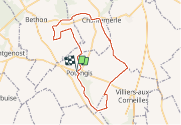
Trail Walking of 16.4 km to be discovered at Grand Est, Marne, Potangis. This trail is proposed by NANE51.

Description

Départ de l’église de Potangis. Beau parcours entre champs, vignes et bois

Elevation profile

Photos

Positioning

Country:
France
Region :
Grand Est
Department/Province :
Marne
Municipality :
Potangis
Location:
Unknown
Start:(UTM)
547376 ; 5381866 (31U) N.

Trails nearby

Trail Walking Conflans-sur-Seine - ENTRE CONFLANS SUR SEINE ET MARCILLY SUR SEINE - Photo
Walking
jeannine grandjean

Walking

Medium
Conflans-sur-Seine, Grand Est, Marne, France
10.7 km | 11.7 km-effort
2h 39min
Yes
Trail Walking Conflans-sur-Seine - au départ de CONFLANS sur SEINE - Photo
Walking
jeannine grandjean

Walking

Easy
Conflans-sur-Seine, Grand Est, Marne, France
15.7 km | 17.5 km-effort
3h 17min
No
Trail Walking Esclavolles-Lurey - esclavolles-lurey, Périgny  - Photo
Walking
cacal51

Walking

Easy
Esclavolles-Lurey, Grand Est, Marne, France
9.8 km | 11 km-effort
1h 58min
Yes
Trail Walking La Celle-sous-Chantemerle - la celle bois de fontaine denis nuisy - Photo
Walking
annisette10

Walking

Difficult
La Celle-sous-Chantemerle, Grand Est, Marne, France
12.5 km | 15.5 km-effort
3h 31min
Yes
Trail Walking Esclavolles-Lurey - Boucle Esclavoles Perigny les éoliennes  - Photo
Walking
NANE51

Walking

Easy
Esclavolles-Lurey, Grand Est, Marne, France
12.6 km | 14.1 km-effort
2h 55min
Yes
Trail Walking Conflans-sur-Seine - Autour de Conflans et Esclavoles - Photo
Walking
NANE51

Walking

Very easy
Conflans-sur-Seine, Grand Est, Marne, France
9.7 km | 10.6 km-effort
1h 53min
Yes
Trail Walking Villiers-aux-Corneilles - Villiers, Chantemerle, Potangis  - Photo
Walking
NANE51

Walking

Easy
(1)
Villiers-aux-Corneilles, Grand Est, Marne, France
12.7 km | 15.2 km-effort
3h 27min
Yes
Trail Walking La Celle-sous-Chantemerle - Boucle la celle vers Chantemerle Bethon - Photo
Walking
NANE51

Walking

La Celle-sous-Chantemerle, Grand Est, Marne, France
12.4 km | 15.2 km-effort
2h 59min
Yes
Trail Walking Esclavolles-Lurey - Esclavolles Esclavolles via éoliennes et Potangis - Photo
Walking
Patrick Castagne

Walking

Medium
Esclavolles-Lurey, Grand Est, Marne, France
10.1 km | 11.9 km-effort
2h 36min
Yes


Close
My subscriptions