![](/images/other/stat-length.png)
![Trail Walking Treffléan - SityTrail - Treffléan (Bizole - Randrécart - Barrage de Trégat) - Photo](https://media.geolcdn.com/t/1900/400/ext.pjpeg?maxdim=2&url=https%3A%2F%2Fstatic1.geolcdn.com%2Fsiteimages%2Fupload%2Ffiles%2F1553511878bg_sport_marche.png)
SityTrail - Treffléan (Bizole - Randrécart - Barrage de Trégat)
PAM2235
User
![Length](/images/other/stat-length.png)
Length
10.7 km
![Max alt](https://static1.geolcdn.com/siteimages/upload/files/1508320355ic_sort_altitude_max_24dp.png)
Max alt
113 m
![Uphill gradient](https://static1.geolcdn.com/siteimages/upload/files/1508320355ic_sort_den_pos_24dp.png)
Uphill gradient
208 m
![Km-Effort](/images/other/stat-length.png)
Km-Effort
13.5 km
![Min alt](https://static1.geolcdn.com/siteimages/upload/files/1508320355ic_sort_altitude_min_24dp.png)
Min alt
47 m
![Downhill gradient](https://static1.geolcdn.com/siteimages/upload/files/1508320355ic_sort_den_neg_24dp.png)
Downhill gradient
207 m
![Boucle](https://static1.geolcdn.com/siteimages/upload/files/16400158638029165_repeat_loop_refresh_sync_direction_icon.png)
Boucle
Yes
Creation date :
2021-04-22 17:30:16.414
Updated on :
2021-04-25 17:51:41.316
![Walking](https://static1.geolcdn.com/sitytour/trail-icons/101.png)
2h40
Difficulty : Difficult
![Scan this QR Code to open this trail in the SityTrail application](https://capi.geolives.com/qq0zvz2zws4bq2lad0pu/sitytour/trails/2757921/qr.png?size=200)
FREE GPS app for hiking
About
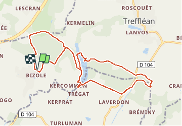
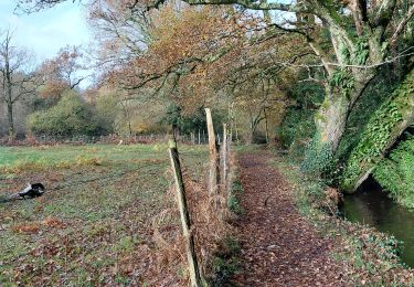
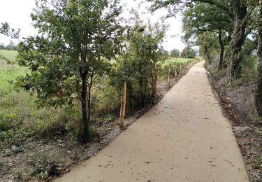
Trail Walking of 10.7 km to be discovered at Brittany, Morbihan, Treffléan. This trail is proposed by PAM2235.
Description
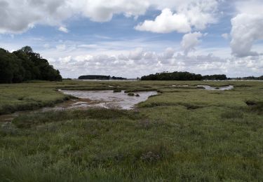
Circuit de 9,6 km au départ du parking situé au chevet de la chapelle de Bizole. Cette variante du circuit de Bizole permet de découvrir le barrage de Trégat.
Positioning
Country:
France
Region :
Brittany
Department/Province :
Morbihan
Municipality :
Treffléan
Location:
Unknown
Start:(Dec)
Start:(UTM)
526382 ; 5279722 (30T) N.
Comments
Trails nearby
![Trail Walking Treffléan - Bizole - Photo](https://media.geolcdn.com/t/375/260/ext.jpg?maxdim=2&url=https%3A%2F%2Fservices.sitytrail.com%2FGeolivesWS%2FDownloadMedia.ashx%3FTrailID%3D191920%26Media%3Dfb5fe928-9f5d-4af5-aad3-ccb04a0144c1.JPG)
![Walking Walking](https://static1.geolcdn.com/sitytour/trail-icons/101.png)
![Trail Walking Treffléan - PR_56_Trefflean_BA_02_Circuit1b_Chemin-De-Cran_20240507 - Photo](https://media.geolcdn.com/t/375/260/b832eb83-9ae2-4127-a1d1-f2e6e6666b1a.jpg&format=jpg&maxdim=2)
![Walking Walking](https://static1.geolcdn.com/sitytour/trail-icons/101.png)
PR_56_Trefflean_BA_02_Circuit1b_Chemin-De-Cran_20240507
Walking
Easy
Treffléan,
Brittany,
Morbihan,
France
![](/images/other/stat-length.png)
5.4 km | 6.5 km-effort
1h 12min
![](https://static1.geolcdn.com/siteimages/upload/files/16400158638029165_repeat_loop_refresh_sync_direction_icon.png)
Yes
![Trail Walking Saint-Nolff - PR_56_St-Nolf_AB_02_Circuit1b_De-La-Vallee-Du-Condat_20240119 - Photo](https://media.geolcdn.com/t/375/260/0e42b6aa-72a8-47c5-a4ef-d03dd001716a.jpg&format=jpg&maxdim=2)
![Walking Walking](https://static1.geolcdn.com/sitytour/trail-icons/101.png)
PR_56_St-Nolf_AB_02_Circuit1b_De-La-Vallee-Du-Condat_20240119
Walking
Easy
Saint-Nolff,
Brittany,
Morbihan,
France
![](/images/other/stat-length.png)
12.4 km | 15.1 km-effort
2h 31min
![](https://static1.geolcdn.com/siteimages/upload/files/16400158638029165_repeat_loop_refresh_sync_direction_icon.png)
Yes
![Trail Walking Treffléan - PR_56_Trefflean_AA_01_Circuit1b_De-La-Chapelle-De-Bizole_20240111 - Photo](https://media.geolcdn.com/t/375/260/33cdd34a-a9e1-478f-975c-2bd4facddb06.jpg&format=jpg&maxdim=2)
![Walking Walking](https://static1.geolcdn.com/sitytour/trail-icons/101.png)
PR_56_Trefflean_AA_01_Circuit1b_De-La-Chapelle-De-Bizole_20240111
Walking
Medium
Treffléan,
Brittany,
Morbihan,
France
![](/images/other/stat-length.png)
6.4 km | 8.2 km-effort
1h 20min
![](https://static1.geolcdn.com/siteimages/upload/files/16400158638029165_repeat_loop_refresh_sync_direction_icon.png)
Yes
![Trail Walking Saint-Nolff - PR_56_St-Nolf_AA_01_Circuit1b-Court_De-La-Vallee-Du-Condat_20231119 - Photo](https://media.geolcdn.com/t/375/260/2b53e2b9-cdcb-4572-9474-136823668337.jpg&format=jpg&maxdim=2)
![Walking Walking](https://static1.geolcdn.com/sitytour/trail-icons/101.png)
PR_56_St-Nolf_AA_01_Circuit1b-Court_De-La-Vallee-Du-Condat_20231119
Walking
Medium
Saint-Nolff,
Brittany,
Morbihan,
France
![](/images/other/stat-length.png)
7.6 km | 9 km-effort
1h 31min
![](https://static1.geolcdn.com/siteimages/upload/files/16400158638029165_repeat_loop_refresh_sync_direction_icon.png)
Yes
![Trail Walking Theix-Noyalo - PR_56_Theix-Noyalo_AA_01_Circuit3b_Vers-Corn-Er-Hoet_20230401 - Photo](https://media.geolcdn.com/t/375/260/53a27219-59ef-468a-9654-2c8ca963d998.jpg&format=jpg&maxdim=2)
![Walking Walking](https://static1.geolcdn.com/sitytour/trail-icons/101.png)
PR_56_Theix-Noyalo_AA_01_Circuit3b_Vers-Corn-Er-Hoet_20230401
Walking
Medium
Theix-Noyalo,
Brittany,
Morbihan,
France
![](/images/other/stat-length.png)
8.3 km | 9.9 km-effort
1h 40min
![](https://static1.geolcdn.com/siteimages/upload/files/16400158638029165_repeat_loop_refresh_sync_direction_icon.png)
Yes
![Trail Mountain bike Theix-Noyalo - 56-vtt-theix-ambon-26km - Photo](https://media.geolcdn.com/t/375/260/eaaae4e6-3ad5-4e2c-842f-c8c95c871393.jpg&format=jpg&maxdim=2)
![Mountain bike Mountain bike](https://static1.geolcdn.com/sitytour/trail-icons/202.png)
56-vtt-theix-ambon-26km
Mountain bike
Easy
(1)
Theix-Noyalo,
Brittany,
Morbihan,
France
![](/images/other/stat-length.png)
27 km | 29 km-effort
1h 51min
![](https://static1.geolcdn.com/siteimages/upload/files/16400158638029165_repeat_loop_refresh_sync_direction_icon.png)
Yes
![Trail Mountain bike Theix-Noyalo - 56-vtt-theix-le-hezo-le-passage-28km - Photo](https://media.geolcdn.com/t/375/260/8557ccb4-2e17-4c47-addf-23d7458c9c8a.jpg&format=jpg&maxdim=2)
![Mountain bike Mountain bike](https://static1.geolcdn.com/sitytour/trail-icons/202.png)
56-vtt-theix-le-hezo-le-passage-28km
Mountain bike
Easy
(1)
Theix-Noyalo,
Brittany,
Morbihan,
France
![](/images/other/stat-length.png)
28 km | 31 km-effort
2h 41min
![](https://static1.geolcdn.com/siteimages/upload/files/16400158638029165_repeat_loop_refresh_sync_direction_icon.png)
Yes
![Trail Mountain bike Theix-Noyalo - 56-vtt-Theix-Séné-St-Armel-34km - Photo](https://media.geolcdn.com/t/375/260/381b67cb-3370-4df9-ba80-427f77016130.jpg&format=jpg&maxdim=2)
![Mountain bike Mountain bike](https://static1.geolcdn.com/sitytour/trail-icons/202.png)
56-vtt-Theix-Séné-St-Armel-34km
Mountain bike
Easy
Theix-Noyalo,
Brittany,
Morbihan,
France
![](/images/other/stat-length.png)
32 km | 35 km-effort
3h 1min
![](https://static1.geolcdn.com/siteimages/upload/files/16400158638029165_repeat_loop_refresh_sync_direction_icon.png)
Yes