Trail Walking Marolles-en-Brie - Ru et parc du Morbras, fort de Sucy et forêt Notre Dame 15 km - Photo

Ru et parc du Morbras, fort de Sucy et forêt Notre Dame 15 km

 Surot
Surot

User

© OpenStreetMap contributors
Length
Length
16 km
Max alt
Max alt
108 m
Uphill gradient
Uphill gradient
155 m
Km-Effort
Km-Effort  
18 km
Min alt
Min alt
49 m
Downhill gradient
Downhill gradient
153 m
Boucle
Boucle
Yes
Creation date :
2021-04-21 07:38:40.0
Updated on :
2021-04-21 15:42:18.203

(0 Reviews)

Walking
Walking
5h28
Difficulty : Difficult

Scan this QR Code to open this trail in the SityTrail application

FREE GPS app for hiking

Logo SityTrail SityTrail

IGN / Geographical institutes

Download SityTrail from the App Store Download SityTrail from Google Play

Logo SityTrail SityTrail World

The world is yours!

Download SityTrail from the App Store Download SityTrail from Google Play Download SityTrail on Huawei AppGallery

About

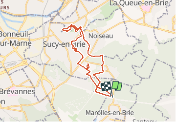
Trail Walking of 16 km to be discovered at Ile-de-France, Val-de-Marne, Marolles-en-Brie. This trail is proposed by Surot.

Description

Par la forêt Notre dame on rejoint la montée du ru de la fontaine de Villiers puis le parc du Morbras AR, puis on traverse de Sucy par sentiers et ruelles et on rejoint le Fort de Sucy dans lequel on peut parfois entrer, puis retour par le parc des sports et la forêt. Peu de difficultés.15 km

Elevation profile

Positioning

Country:
France
Region :
Ile-de-France
Department/Province :
Val-de-Marne
Municipality :
Marolles-en-Brie
Location:
Unknown
Start:(UTM)
467279 ; 5399389 (31U) N.

Trails nearby

Trail Walking Marolles-en-Brie - GRP CV-IDF 05 - Photo
Walking
clalaur

Walking

Difficult
(1)
Marolles-en-Brie, Ile-de-France, Val-de-Marne, France
13.5 km | 15.2 km-effort
3h 27min
No
Trail Walking Mandres-les-Roses - J 26 Mandres, Boussy , Brunoy le chemin des fresques  - Photo
Walking

Walking

Medium
(2)
Mandres-les-Roses, Ile-de-France, Val-de-Marne, France
12.2 km | 13.8 km-effort
3h 7min
Yes
Trail On foot Servon - J 01  11.97 km  les 5 châteaux  - Photo
On foot

On foot

Medium
(1)
Servon, Ile-de-France, Seine-et-Marne, France
11.7 km | 13.2 km-effort
3h 3min
Yes
Trail On foot Servon - R 04 - 8 km -  Servon, Santeny, Servon - Photo
On foot

On foot

Very difficult
(4)
Servon, Ile-de-France, Seine-et-Marne, France
7.9 km | 9.1 km-effort
2h 3min
Yes
Trail Walking Noiseau - depuis Noiseau - Photo
Walking
Bernardroland

Walking

Easy
(2)
Noiseau, Ile-de-France, Val-de-Marne, France
17 km | 19.1 km-effort
4h 35min
Yes
Trail Walking Yerres - BM Foret Regionale de Grobois 10km - Photo
Walking
GUIDE
jeanmarcMasson

Walking

Medium
(1)
Yerres, Ile-de-France, Essonne, France
10.4 km | 11 km-effort
2h 30min
Yes
Trail Walking Yerres - BM Foret Regionale Grosbois 10km - Photo
Walking
GUIDE
jeanmarcMasson

Walking

Medium
(1)
Yerres, Ile-de-France, Essonne, France
9.8 km | 10.5 km-effort
2h 23min
Yes
Trail Walking Yerres - J 43  Yerres Parc Caillebotte, île des Prévôts - Photo
Walking

Walking

Medium
(2)
Yerres, Ile-de-France, Essonne, France
11.4 km | 13.1 km-effort
2h 59min
Yes
Trail Walking Servon - JC 24 Servon , Villecresnes, forêt de la Grange   - Photo
Walking

Walking

Difficult
(3)
Servon, Ile-de-France, Seine-et-Marne, France
20 km | 22 km-effort
5h 6min
Yes


Close
My subscriptions