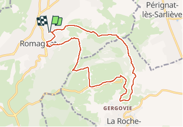
![](/images/other/stat-length.png)
![Trail Walking Romagnat - 2021-04-21_10h43m39_Cirkwi-Le_plateau_de_Gergovie - Photo](https://media.geolcdn.com/t/1900/400/ext.pjpeg?maxdim=2&url=https%3A%2F%2Fstatic1.geolcdn.com%2Fsiteimages%2Fupload%2Ffiles%2F1553511878bg_sport_marche.png)
2021-04-21_10h43m39_Cirkwi-Le_plateau_de_Gergovie
jpcccb
User
![Length](/images/other/stat-length.png)
![Max alt](https://static1.geolcdn.com/siteimages/upload/files/1508320355ic_sort_altitude_max_24dp.png)
![Uphill gradient](https://static1.geolcdn.com/siteimages/upload/files/1508320355ic_sort_den_pos_24dp.png)
![Km-Effort](/images/other/stat-length.png)
![Min alt](https://static1.geolcdn.com/siteimages/upload/files/1508320355ic_sort_altitude_min_24dp.png)
![Downhill gradient](https://static1.geolcdn.com/siteimages/upload/files/1508320355ic_sort_den_neg_24dp.png)
![Boucle](https://static1.geolcdn.com/siteimages/upload/files/16400158638029165_repeat_loop_refresh_sync_direction_icon.png)
![Walking](https://static1.geolcdn.com/sitytour/trail-icons/101.png)
3h10
Difficulty : Difficult
![Scan this QR Code to open this trail in the SityTrail application](https://capi.geolives.com/qq0zvz2zws4bq2lad0pu/sitytour/trails/2755897/qr.png?size=200)
FREE GPS app for hiking
About
Trail Walking of 9.6 km to be discovered at Auvergne-Rhône-Alpes, Puy-de-Dôme, Romagnat. This trail is proposed by jpcccb.
Description
Ce belvédère naturel offre un point de vue privilégié sur les plaines de la Limagne et du val d’Allier, et sur les volcans d’Auvergne. Cet ancien oppidum fut le théâtre de la défaite de Jules César devant Vercingétorix en 52 avant notre ère.Départ - De la cour de la mairie, prendre l’avenue de la République à gauche puis la rue des Caves à droite. Aller jusqu'à la rue de la Treille et l’emprunter à droite, prendre ensuite l’allée André-Guinant à gauche. À son extrémité, contourner le bâtiment par la droite et ressortir sur la rue que l’on prend à gauche jusqu'à la rue des Fours à chaux. 1 - Monter à gauche la rue des Fours à chaux (sculptures métalliques d’Yves Guérin) et continuer sur un chemin qui monte en sous-bois. Après la sortie du bois continuer tout droit jusqu’à hauteur d’une barrière à l’entrée d’un pré à droite. Monter en rétrograde par un sentier à gauche jusqu'à un pierrier au sommet du plateau (point de vue sur la chaîne des Puys et l’agglomération clermontoise). 2 - Suivre le bord du plateau par la gauche, puis prendre le deuxième chemin à droite pour rejoindre la route. Emprunter tout de suite à gauche le chemin qui la longe en direction du monument dédié à Vercingétorix (large point de vue sur les monts du Forez, la Comté, la vallée de l’Allier, le Cézallier, le plateau de la Serre). Aller jusqu'à la rue de la Treille et l’emprunter à droite, prendre ensuite l’allée André-Guinant à gauche. À son extrémité, contourner le bâtiment par la droite et ressortir sur la rue que l’on prend à gauche jusqu'à la rue des Fours à chaux. 3 - Descendre sous la "Maison de Gergovie" par le sentier du puy Mardoux (panneau directionnel), traverser un large chemin et continuer à descendre jusqu'aux premières maisons du village de Gergovie. 4 - Remonter à gauche, passer à proximité d’une croix et continuer tout droit (site des Rocs Rouges et du puy Mardoux). Descendre le chemin en restant à droite aux deux fourches suivantes jusqu'à une intersection dans un vallon humide. 5 - Prendre un chemin à gauche jusqu'aux premières maisons de Romagnat en ignorant les chemins à droite et à gauche. À la croix en pierre descendre à droite. Au bas de la rue des Cerisiers, prendre à gauche pour rejoindre le point de départ.
Positioning
Comments
Trails nearby
![Trail Walking Royat - Royat_Haut_Chamalieres - Photo](https://media.geolcdn.com/t/375/260/b2b61a3d-216c-41ca-b3c5-c12e3597cfee.jpg&format=jpg&maxdim=2)
![Walking Walking](https://static1.geolcdn.com/sitytour/trail-icons/101.png)
Walking
![](/images/other/stat-length.png)
![](https://static1.geolcdn.com/siteimages/upload/files/16400158638029165_repeat_loop_refresh_sync_direction_icon.png)
![Trail Walking Ceyrat - Ceyrat_Tour_Montrognon - Photo](https://media.geolcdn.com/t/375/260/d4065319-6593-4bc3-b128-db804820f375.jpg&format=jpg&maxdim=2)
![Walking Walking](https://static1.geolcdn.com/sitytour/trail-icons/101.png)
Walking
![](/images/other/stat-length.png)
![](https://static1.geolcdn.com/siteimages/upload/files/16400158638029165_repeat_loop_refresh_sync_direction_icon.png)
![Trail Walking Royat - Royat_Paradis - Photo](https://media.geolcdn.com/t/375/260/40a920bf-98ae-44a7-8509-dbb3cd58b58b.jpg&format=jpg&maxdim=2)
![Walking Walking](https://static1.geolcdn.com/sitytour/trail-icons/101.png)
Walking
![](/images/other/stat-length.png)
![](https://static1.geolcdn.com/siteimages/upload/files/16400158638029165_repeat_loop_refresh_sync_direction_icon.png)
![Trail Walking Royat - Royat_Chemin_Ecoliers - Photo](https://media.geolcdn.com/t/375/260/45acbefc-a834-46ca-83ad-58408101e47d.jpg&format=jpg&maxdim=2)
![Walking Walking](https://static1.geolcdn.com/sitytour/trail-icons/101.png)
Walking
![](/images/other/stat-length.png)
![](https://static1.geolcdn.com/siteimages/upload/files/16400158638029165_repeat_loop_refresh_sync_direction_icon.png)
![Trail Walking Royat - Oclede-GraveNoire-Charade_T - Photo](https://media.geolcdn.com/t/375/260/acb0504d-7485-4653-a888-66c4efb79c9d.jpg&format=jpg&maxdim=2)
![Walking Walking](https://static1.geolcdn.com/sitytour/trail-icons/101.png)
Walking
![](/images/other/stat-length.png)
![](https://static1.geolcdn.com/siteimages/upload/files/16400158638029165_repeat_loop_refresh_sync_direction_icon.png)
![Trail Walking Romagnat - Le Puy Giroux près d'Opme - Photo](https://media.geolcdn.com/t/375/260/ext.jpg?maxdim=2&url=https%3A%2F%2Fservices.sitytrail.com%2FGeolivesWS%2FDownloadMedia.ashx%3FTrailID%3D107482%26Media%3D12426_1.jpg)
![Walking Walking](https://static1.geolcdn.com/sitytour/trail-icons/101.png)
Walking
![](/images/other/stat-length.png)
![](https://static1.geolcdn.com/siteimages/upload/files/16400158638029165_repeat_loop_refresh_sync_direction_icon.png)
![Trail On foot Aubière - Le chemin des orchys - Photo](https://media.geolcdn.com/t/375/260/84f023b1-c900-42ac-9013-dc3ef3430b61.jpeg&format=jpg&maxdim=2)
![On foot On foot](https://static1.geolcdn.com/sitytour/trail-icons/100.png)
On foot
![](/images/other/stat-length.png)
![](https://static1.geolcdn.com/siteimages/upload/files/16400158638029165_repeat_loop_refresh_sync_direction_icon.png)
![Trail On foot Chanonat - Le Crest - Photo](https://media.geolcdn.com/t/375/260/c9b3d1da-554f-4873-8d44-afc3e6570967.jpeg&format=jpg&maxdim=2)
![On foot On foot](https://static1.geolcdn.com/sitytour/trail-icons/100.png)
On foot
![](/images/other/stat-length.png)
![](https://static1.geolcdn.com/siteimages/upload/files/16400158638029165_repeat_loop_refresh_sync_direction_icon.png)
![Trail On foot Royat - Le Chemin des Ecoliers - Photo](https://media.geolcdn.com/t/375/260/eb1d4ed7-ea58-4e0c-8360-ec45921f8104.jpeg&format=jpg&maxdim=2)
![On foot On foot](https://static1.geolcdn.com/sitytour/trail-icons/100.png)
On foot
![](/images/other/stat-length.png)
![](https://static1.geolcdn.com/siteimages/upload/files/16400158638029165_repeat_loop_refresh_sync_direction_icon.png)