![](/images/other/stat-length.png)
![Trail Walking Deux-Grosnes - Avenas - Photo](https://media.geolcdn.com/t/1900/400/ext.pjpeg?maxdim=2&url=https%3A%2F%2Fstatic1.geolcdn.com%2Fsiteimages%2Fupload%2Ffiles%2F1553511878bg_sport_marche.png)
Avenas
fernand1254
User
![Length](/images/other/stat-length.png)
Length
12.3 km
![Max alt](https://static1.geolcdn.com/siteimages/upload/files/1508320355ic_sort_altitude_max_24dp.png)
Max alt
887 m
![Uphill gradient](https://static1.geolcdn.com/siteimages/upload/files/1508320355ic_sort_den_pos_24dp.png)
Uphill gradient
453 m
![Km-Effort](/images/other/stat-length.png)
Km-Effort
18.4 km
![Min alt](https://static1.geolcdn.com/siteimages/upload/files/1508320355ic_sort_altitude_min_24dp.png)
Min alt
508 m
![Downhill gradient](https://static1.geolcdn.com/siteimages/upload/files/1508320355ic_sort_den_neg_24dp.png)
Downhill gradient
453 m
![Boucle](https://static1.geolcdn.com/siteimages/upload/files/16400158638029165_repeat_loop_refresh_sync_direction_icon.png)
Boucle
Yes
Creation date :
2021-04-18 06:35:16.218
Updated on :
2021-04-18 10:53:42.927
![Walking](https://static1.geolcdn.com/sitytour/trail-icons/101.png)
3h21
Difficulty : Medium
![Scan this QR Code to open this trail in the SityTrail application](https://capi.geolives.com/qq0zvz2zws4bq2lad0pu/sitytour/trails/2752077/qr.png?size=200)
FREE GPS app for hiking
About
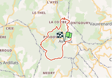
Trail Walking of 12.3 km to be discovered at Auvergne-Rhône-Alpes, Rhône, Deux-Grosnes. This trail is proposed by fernand1254.
Description
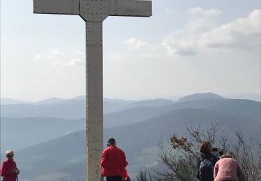
Stationner sur le parking qui se trouve le long de la route en face de l'église. Passer devant la mairie. Faire env 400m en direction d'Ouroux. Là on récupère un chemin. Balisage :lapin couché sur fond vert ou flèches sur fond vert. À la croix on prend le GR jusqu'à Avenas
Positioning
Country:
France
Region :
Auvergne-Rhône-Alpes
Department/Province :
Rhône
Municipality :
Deux-Grosnes
Location:
Avenas
Start:(Dec)
Start:(UTM)
623781 ; 5116929 (31T) N.
Comments
Trails nearby
![Trail Walking Deux-Grosnes - Ouroux - Photo](https://media.geolcdn.com/t/375/260/8cef6e4d-d107-4e31-8a02-a874193353f3.jpg&format=jpg&maxdim=2)
![Walking Walking](https://static1.geolcdn.com/sitytour/trail-icons/101.png)
Ouroux
Walking
Difficult
(1)
Deux-Grosnes,
Auvergne-Rhône-Alpes,
Rhône,
France
![](/images/other/stat-length.png)
19.1 km | 0 m-effort
5h 57min
![](https://static1.geolcdn.com/siteimages/upload/files/16400158638029165_repeat_loop_refresh_sync_direction_icon.png)
Yes
![Trail Walking Vauxrenard - Itinérant Beaujolais rouge étape 6 Foretal - Macon gare TGV - Photo](https://media.geolcdn.com/t/375/260/413cab1b-506e-4c3e-962c-5987ea1a88f6.jpg&format=jpg&maxdim=2)
![Walking Walking](https://static1.geolcdn.com/sitytour/trail-icons/101.png)
Itinérant Beaujolais rouge étape 6 Foretal - Macon gare TGV
Walking
Very difficult
Vauxrenard,
Auvergne-Rhône-Alpes,
Rhône,
France
![](/images/other/stat-length.png)
23 km | 28 km-effort
6h 26min
![](https://static1.geolcdn.com/siteimages/upload/files/16400158638029165_repeat_loop_refresh_sync_direction_icon.png)
No
![Trail Walking Chiroubles - Itinérant Beaujolais rouge étape 5 Chiroubles- Foretal - Photo](https://media.geolcdn.com/t/375/260/bf6c4c39-6cf0-41e3-8fc7-ac4d114e4ee5.jpg&format=jpg&maxdim=2)
![Walking Walking](https://static1.geolcdn.com/sitytour/trail-icons/101.png)
Itinérant Beaujolais rouge étape 5 Chiroubles- Foretal
Walking
Medium
Chiroubles,
Auvergne-Rhône-Alpes,
Rhône,
France
![](/images/other/stat-length.png)
23 km | 32 km-effort
5h 44min
![](https://static1.geolcdn.com/siteimages/upload/files/16400158638029165_repeat_loop_refresh_sync_direction_icon.png)
No
![Trail Walking Beaujeu - Itinérant Beaujolais rouge étape 4 . Malval - Chiroubles - Photo](https://media.geolcdn.com/t/375/260/7e353f10-ae9e-4e5c-a303-dba8e616c8c7.jpg&format=jpg&maxdim=2)
![Walking Walking](https://static1.geolcdn.com/sitytour/trail-icons/101.png)
Itinérant Beaujolais rouge étape 4 . Malval - Chiroubles
Walking
Medium
Beaujeu,
Auvergne-Rhône-Alpes,
Rhône,
France
![](/images/other/stat-length.png)
26 km | 34 km-effort
5h 40min
![](https://static1.geolcdn.com/siteimages/upload/files/16400158638029165_repeat_loop_refresh_sync_direction_icon.png)
No
![Trail Walking Vauxrenard - vauxrenard - Photo](https://media.geolcdn.com/t/375/260/ext.jpg?maxdim=2&url=https%3A%2F%2Fstatic1.geolcdn.com%2Fsiteimages%2Fupload%2Ffiles%2F1553511878bg_sport_marche.png)
![Walking Walking](https://static1.geolcdn.com/sitytour/trail-icons/101.png)
vauxrenard
Walking
Difficult
(1)
Vauxrenard,
Auvergne-Rhône-Alpes,
Rhône,
France
![](/images/other/stat-length.png)
21 km | 31 km-effort
5h 7min
![](https://static1.geolcdn.com/siteimages/upload/files/16400158638029165_repeat_loop_refresh_sync_direction_icon.png)
Yes
![Trail Walking Chiroubles - circuit des crêtes du fût d'Avenas - Photo](https://media.geolcdn.com/t/375/260/5ef15404-af20-4f2b-8081-8ca495b203b9.jpg&format=jpg&maxdim=2)
![Walking Walking](https://static1.geolcdn.com/sitytour/trail-icons/101.png)
circuit des crêtes du fût d'Avenas
Walking
Difficult
Chiroubles,
Auvergne-Rhône-Alpes,
Rhône,
France
![](/images/other/stat-length.png)
13.8 km | 20 km-effort
3h 20min
![](https://static1.geolcdn.com/siteimages/upload/files/16400158638029165_repeat_loop_refresh_sync_direction_icon.png)
Yes
![Trail Walking Chiroubles - 2023-05-26_00h30m21_28127-15675317-2 (2) - Photo](https://media.geolcdn.com/t/375/260/ext.jpg?maxdim=2&url=https%3A%2F%2Fstatic1.geolcdn.com%2Fsiteimages%2Fupload%2Ffiles%2F1553511878bg_sport_marche.png)
![Walking Walking](https://static1.geolcdn.com/sitytour/trail-icons/101.png)
2023-05-26_00h30m21_28127-15675317-2 (2)
Walking
Very difficult
(1)
Chiroubles,
Auvergne-Rhône-Alpes,
Rhône,
France
![](/images/other/stat-length.png)
16.9 km | 26 km-effort
5h 49min
![](https://static1.geolcdn.com/siteimages/upload/files/16400158638029165_repeat_loop_refresh_sync_direction_icon.png)
Yes
![Trail On foot Deux-Grosnes - Circuit des Sapins - Photo](https://media.geolcdn.com/t/375/260/358eb254-a341-41ca-ac19-9b6a7242af0e.jpeg&format=jpg&maxdim=2)
![On foot On foot](https://static1.geolcdn.com/sitytour/trail-icons/100.png)
Circuit des Sapins
On foot
Difficult
Deux-Grosnes,
Auvergne-Rhône-Alpes,
Rhône,
France
![](/images/other/stat-length.png)
22 km | 33 km-effort
7h 34min
![](https://static1.geolcdn.com/siteimages/upload/files/16400158638029165_repeat_loop_refresh_sync_direction_icon.png)
Yes
![Trail Walking Chiroubles - Fût d’Avenas (13 km - D. 455 m) - Photo](https://media.geolcdn.com/t/375/260/a25dadc2-d581-41f4-b844-883fbaf4f91a.jpeg&format=jpg&maxdim=2)
![Walking Walking](https://static1.geolcdn.com/sitytour/trail-icons/101.png)
Fût d’Avenas (13 km - D. 455 m)
Walking
Medium
(1)
Chiroubles,
Auvergne-Rhône-Alpes,
Rhône,
France
![](/images/other/stat-length.png)
13 km | 19.1 km-effort
4h 21min
![](https://static1.geolcdn.com/siteimages/upload/files/16400158638029165_repeat_loop_refresh_sync_direction_icon.png)
Yes