Trail On foot Solliès-Ville - sollies matheron coudon - Photo
© OpenStreetMap contributors
Length
Length
13.3 km
Max alt
Max alt
646 m
Uphill gradient
Uphill gradient
773 m
Km-Effort
Km-Effort  
24 km
Min alt
Min alt
218 m
Downhill gradient
Downhill gradient
774 m
Boucle
Boucle
Yes
Creation date :
2021-04-15 06:14:21.226
Updated on :
2021-04-15 07:18:33.761

(0 Reviews)

On foot
On foot
5h21
Difficulty : Medium

Scan this QR Code to open this trail in the SityTrail application

FREE GPS app for hiking

Logo SityTrail SityTrail

IGN / Geographical institutes

Download SityTrail from the App Store Download SityTrail from Google Play

Logo SityTrail SityTrail World

The world is yours!

Download SityTrail from the App Store Download SityTrail from Google Play Download SityTrail on Huawei AppGallery

About

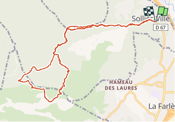
Trail On foot of 13.3 km to be discovered at Provence-Alpes-Côte d'Azur, Var, Solliès-Ville. This trail is proposed by cdanielrando.

Description

Départ et retour du village de Sollies-ville.
Au km 2, prendre à gauche le sentier qui monte sur la crête du Matheron, départ peu visible. Sur la crête, la vue est superbe à la fois vers la mer et vers l'intérieur des terres. La montée au fort du bau pointu est assez sévère mais le point de vue sur la rade de Toulon est magnifique. Suivre la route qui mène au fort  et entamer la descente vers le petit Coudon en suivant le Gr. Nouveauté, sur le sommet du petit Coudon, une croix vient juste d'être installée, voir photos. Une superbe randonnée un peu difficile compte tenu du dénivelé important sur une distance relativement courte

Elevation profile

Photos

Positioning

Country:
France
Region :
Provence-Alpes-Côte d'Azur
Department/Province :
Var
Municipality :
Solliès-Ville
Location:
Unknown
Start:(UTM)
259417 ; 4785193 (32T) N.

Trails nearby

Trail Walking Solliès-Toucas - Valaury - Apier - Matheron - Photo
Walking
GUIDE
affinetataille

Walking

Medium
(1)
Solliès-Toucas, Provence-Alpes-Côte d'Azur, Var, France
13.1 km | 19.5 km-effort
5h 0min
Yes
Trail Walking La Valette-du-Var - SityTrail - Le tour du coudon - Photo
Walking
GUIDE
affinetataille

Walking

Difficult
(1)
La Valette-du-Var, Provence-Alpes-Côte d'Azur, Var, France
11.9 km | 19.4 km-effort
5h 0min
Yes
Trail Walking La Crau - fenouillet Daniel Louis - Photo
Walking
cdanielrando

Walking

Medium
(1)
La Crau, Provence-Alpes-Côte d'Azur, Var, France
18.1 km | 25 km-effort
4h 36min
Yes
Trail Walking La Crau - le fenouillet un après-midi d'automne  - Photo
Walking
le.noceur

Walking

Easy
(2)
La Crau, Provence-Alpes-Côte d'Azur, Var, France
7.6 km | 10.7 km-effort
1h 48min
Yes
Trail Walking Solliès-Toucas - couvent St Hubert Valaury - Photo
Walking
marchev

Walking

Very easy
(2)
Solliès-Toucas, Provence-Alpes-Côte d'Azur, Var, France
12.5 km | 19.2 km-effort
4h 30min
Yes
Trail Walking La Crau - Fenouillet - Chateau de Hyères - retour par les vignes - Photo
Walking
GUIDE
affinetataille

Walking

Medium
(2)
La Crau, Provence-Alpes-Côte d'Azur, Var, France
14.1 km | 19.7 km-effort
5h 0min
Yes
Trail Walking La Farlède - La farlède-Tourris - Photo
Walking
FSantoni

Walking

Very difficult
La Farlède, Provence-Alpes-Côte d'Azur, Var, France
16 km | 23 km-effort
6h 36min
Yes
Trail Walking Solliès-Pont - Lac de Montbel - Photo
Walking
Surfou

Walking

Very difficult
Solliès-Pont, Provence-Alpes-Côte d'Azur, Var, France
14.1 km | 20 km-effort
4h 34min
Yes
Trail Walking La Valette-du-Var - le Coudon - Photo
Walking
cousam

Walking

Difficult
La Valette-du-Var, Provence-Alpes-Côte d'Azur, Var, France
4.1 km | 8.7 km-effort
2h 54min
No


Close
My subscriptions