Trail On foot Montireau - MONTIREAU 22 - Photo
© OpenStreetMap contributors
Length
Length
22 km
Max alt
Max alt
291 m
Uphill gradient
Uphill gradient
252 m
Km-Effort
Km-Effort  
26 km
Min alt
Min alt
226 m
Downhill gradient
Downhill gradient
250 m
Boucle
Boucle
Yes
Creation date :
2021-04-13 16:02:30.353
Updated on :
2021-04-13 16:03:17.27

(0 Reviews)

On foot
On foot
5h48
Difficulty : Medium

Scan this QR Code to open this trail in the SityTrail application

FREE GPS app for hiking

Logo SityTrail SityTrail

IGN / Geographical institutes

Download SityTrail from the App Store Download SityTrail from Google Play

Logo SityTrail SityTrail World

The world is yours!

Download SityTrail from the App Store Download SityTrail from Google Play Download SityTrail on Huawei AppGallery

About

Trail On foot of 22 km to be discovered at Centre-Loire Valley, Eure-et-Loir, Montireau. This trail is proposed by Martine28240.

Elevation profile

Positioning

Country:
France
Region :
Centre-Loire Valley
Department/Province :
Eure-et-Loir
Municipality :
Montireau
Location:
Unknown
Start:(UTM)
353941 ; 5363539 (31U) N.

Trails nearby

Trail Walking Saint-Victor-de-Buthon - Saint-Victor-de-Buthon - Thiron-Gardais 17 km - Photo
Walking

Walking

Very difficult
Saint-Victor-de-Buthon, Centre-Loire Valley, Eure-et-Loir, France
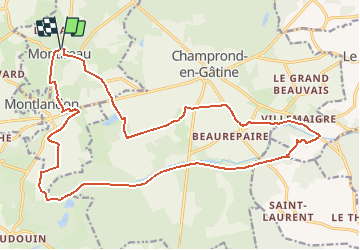
17.7 km | 21 km-effort
4h 34min
No
Trail Walking Saint-Victor-de-Buthon - St Victor de Buthon 22 - Photo
Walking
togolo28

Walking

Easy
(1)
Saint-Victor-de-Buthon, Centre-Loire Valley, Eure-et-Loir, France
22 km | 28 km-effort
5h 57min
Yes
Trail Walking Saint-Victor-de-Buthon - Saint-Victor de Buthon 8,5 km - Photo
Walking
ODDAD78

Walking

Medium
Saint-Victor-de-Buthon, Centre-Loire Valley, Eure-et-Loir, France
8.5 km | 9.9 km-effort
2h 14min
Yes
Trail Walking Saint-Victor-de-Buthon - [Itinéraire] Le chemin des demoiselles - Photo
Walking
ODDAD78

Walking

Medium
Saint-Victor-de-Buthon, Centre-Loire Valley, Eure-et-Loir, France
8.4 km | 9.8 km-effort
2h 14min
Yes
Trail Mountain bike Saint-Victor-de-Buthon - [Itinéraire] Par monts et par vaux - Photo
Mountain bike
ODDAD78

Mountain bike

Very difficult
Saint-Victor-de-Buthon, Centre-Loire Valley, Eure-et-Loir, France
39 km | 47 km-effort
3h 16min
Yes
Trail Walking Saint-Victor-de-Buthon - 10747652-ZLa Loupe - St Victor de Buthon 17.21 - Photo
Walking
togolo28

Walking

Medium
Saint-Victor-de-Buthon, Centre-Loire Valley, Eure-et-Loir, France
17.2 km | 21 km-effort
Unknown
No
Trail Walking Champrond-en-Gâtine - TPE 2018 Etape 10 Champrond-en-Gâtine - Senonches 32,6km - Photo
Walking
ODDAD78

Walking

Easy
Champrond-en-Gâtine, Centre-Loire Valley, Eure-et-Loir, France
33 km | 37 km-effort
7h 59min
No
Trail Other activity Saint-Victor-de-Buthon - Quad avec ceriaque - Photo
Other activity
angelhm

Other activity

Very easy
Saint-Victor-de-Buthon, Centre-Loire Valley, Eure-et-Loir, France
62 km | 78 km-effort
3h 5min
No
Trail Walking Champrond-en-Gâtine - BEAUREPAIRE CHAMPROND EN G. 11.200 - Photo
Walking
Martine28240

Walking

Very easy
Champrond-en-Gâtine, Centre-Loire Valley, Eure-et-Loir, France
11.2 km | 12.6 km-effort
2h 51min
Yes


Close
My subscriptions