Trail On foot Corbonod - Arviere  Sur Lyand - Photo
© OpenStreetMap contributors
Length
Length
10.2 km
Max alt
Max alt
1416 m
Uphill gradient
Uphill gradient
359 m
Km-Effort
Km-Effort  
15 km
Min alt
Min alt
1146 m
Downhill gradient
Downhill gradient
358 m
Boucle
Boucle
Yes
Creation date :
2021-04-12 16:46:31.433
Updated on :
2021-04-13 16:13:22.162

(0 Reviews)

On foot
On foot
3h23
Difficulty : Easy

Scan this QR Code to open this trail in the SityTrail application

FREE GPS app for hiking

Logo SityTrail SityTrail

IGN / Geographical institutes

Download SityTrail from the App Store Download SityTrail from Google Play

Logo SityTrail SityTrail World

The world is yours!

Download SityTrail from the App Store Download SityTrail from Google Play Download SityTrail on Huawei AppGallery

About

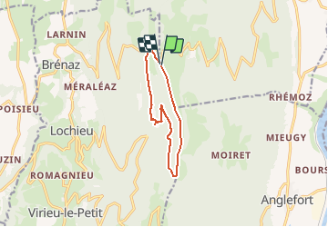
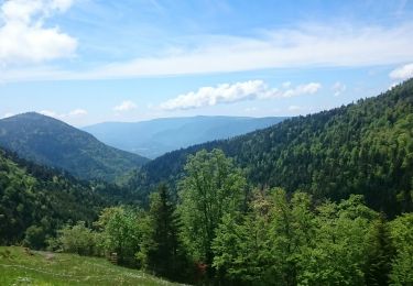
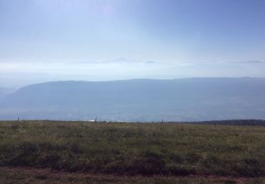
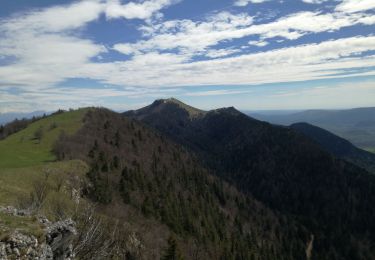
Trail On foot of 10.2 km to be discovered at Auvergne-Rhône-Alpes, Ain, Corbonod. This trail is proposed by michel.pegaz.

Description

Parking croix de Flamban après le foyer de ski de fond de Sur Lyand. Aller vers le sud par la crête en direction du Col de Charbemenes. Au col prendre le sentier direction nord-ouest pour rejoindre le site d'Arviere. Revenir au parking par le GR 9 Tour du Valromey.

Elevation profile

Positioning

Country:
France
Region :
Auvergne-Rhône-Alpes
Department/Province :
Ain
Municipality :
Corbonod
Location:
Unknown
Start:(UTM)
714001 ; 5091914 (31T) N.

Trails nearby

Trail Walking Corbonod - GRAND COLOMBIER: SUR LYAND - CHARBEMENES - CHALET D'ARVIERES - Photo
Walking
djeepee74

Walking

Medium
(1)
Corbonod, Auvergne-Rhône-Alpes, Ain, France
13.5 km | 19.7 km-effort
4h 30min
Yes
Trail Walking Arvière-en-Valromey - SUR LYAND NORD via corniche & balcon Valromey et GR9 - Photo
Walking
djeepee74

Walking

Difficult
Arvière-en-Valromey, Auvergne-Rhône-Alpes, Ain, France
26 km | 36 km-effort
6h 35min
Yes
Trail Walking Corbonod - GRAND COLOMBIER: SUR LYAND - CHARBEMENES par les crêtes - COLOMBIER - RETOUR PAR VALLON D'ARVIERES - Photo
Walking
djeepee74

Walking

Medium
Corbonod, Auvergne-Rhône-Alpes, Ain, France
14.5 km | 22 km-effort
4h 30min
Yes
Trail Walking Arvière-en-Valromey - Chalet d'Arvières - Photo
Walking
Michel_Martin

Walking

Easy
Arvière-en-Valromey, Auvergne-Rhône-Alpes, Ain, France
10.5 km | 15.3 km-effort
3h 15min
Yes
Trail Walking Arvière-en-Valromey - GR 9 - Étape 13 - Chalet d’Arvières - Chanaz - Photo
Walking
pcugnod

Walking

Very difficult
Arvière-en-Valromey, Auvergne-Rhône-Alpes, Ain, France
27 km | 0 m-effort
7h 33min
No
Trail Walking Corbonod - combe merlin - Photo
Walking
jibe01

Walking

Easy
Corbonod, Auvergne-Rhône-Alpes, Ain, France
9.9 km | 14.1 km-effort
2h 1min
Yes
Trail Walking Arvière-en-Valromey - GTJ 13 Chalet d'Arviere/Culoz - Photo
Walking
Praff

Walking

Medium
Arvière-en-Valromey, Auvergne-Rhône-Alpes, Ain, France
20 km | 29 km-effort
6h 18min
No
Trail Walking Corbonod - GRAND COLOMBIER: SUR LYAND - CHARBEMENES PAR LES CRETES - ARVIERES par la
Walking
djeepee74

Walking

Medium
(1)
Corbonod, Auvergne-Rhône-Alpes, Ain, France
14.4 km | 21 km-effort
4h 36min
Yes
Trail Walking Arvière-en-Valromey - LE GRAND COLOMBIER - Photo
Walking
Jean-Paulchoux

Walking

Medium
Arvière-en-Valromey, Auvergne-Rhône-Alpes, Ain, France
14.9 km | 24 km-effort
5h 27min
Yes


Close
My subscriptions