![](/images/other/stat-length.png)
![Trail Walking Malmedy - Malmedy 22 - Les crêtes de la Warche - Photo](https://media.geolcdn.com/t/1900/400/ext.pjpeg?maxdim=2&url=https%3A%2F%2Fstatic1.geolcdn.com%2Fsiteimages%2Fupload%2Ffiles%2F1553511878bg_sport_marche.png)
Malmedy 22 - Les crêtes de la Warche
verpoorten
User
![Length](/images/other/stat-length.png)
Length
16.8 km
![Max alt](https://static1.geolcdn.com/siteimages/upload/files/1508320355ic_sort_altitude_max_24dp.png)
Max alt
522 m
![Uphill gradient](https://static1.geolcdn.com/siteimages/upload/files/1508320355ic_sort_den_pos_24dp.png)
Uphill gradient
469 m
![Km-Effort](/images/other/stat-length.png)
Km-Effort
23 km
![Min alt](https://static1.geolcdn.com/siteimages/upload/files/1508320355ic_sort_altitude_min_24dp.png)
Min alt
353 m
![Downhill gradient](https://static1.geolcdn.com/siteimages/upload/files/1508320355ic_sort_den_neg_24dp.png)
Downhill gradient
470 m
![Boucle](https://static1.geolcdn.com/siteimages/upload/files/16400158638029165_repeat_loop_refresh_sync_direction_icon.png)
Boucle
Yes
Creation date :
2021-04-11 12:24:08.436
Updated on :
2021-04-11 13:34:45.309
![Walking](https://static1.geolcdn.com/sitytour/trail-icons/101.png)
5h14
Difficulty : Very difficult
![Scan this QR Code to open this trail in the SityTrail application](https://capi.geolives.com/qq0zvz2zws4bq2lad0pu/sitytour/trails/2743267/qr.png?size=200)
FREE GPS app for hiking
About
Trail Walking of 16.8 km to be discovered at Wallonia, Liège, Malmedy. This trail is proposed by verpoorten.
Description
Magnifique randonnée passant par les crêtes de la Warche, en découvrant des panoramas fabuleux, ainsi que le Château de Reinhardstein. Passage par les vallées de la Warche, du Coreu, du Pouhon, du Bayehon, le barrage de Robertville. Pour sportifs
Positioning
Country:
Belgium
Region :
Wallonia
Department/Province :
Liège
Municipality :
Malmedy
Location:
Bevercé
Start:(Dec)
Start:(UTM)
291949 ; 5593846 (32U) N.
Comments
Trails nearby
![Trail Walking Waimes - RB-Lg-32_Botrange_via-racc-2 - Photo](https://media.geolcdn.com/t/375/260/ext.jpg?maxdim=2&url=https%3A%2F%2Fservices.sitytrail.com%2FGeolivesWS%2FDownloadMedia.ashx%3FTrailID%3D402164%26Media%3D5ad16311-48f2-4779-8b73-f8bce456ef00.jpg)
![Walking Walking](https://static1.geolcdn.com/sitytour/trail-icons/101.png)
RB-Lg-32_Botrange_via-racc-2
Walking
(6)
Waimes,
Wallonia,
Liège,
Belgium
![](/images/other/stat-length.png)
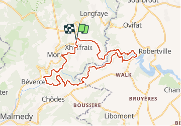
16.7 km | 22 km-effort
5h 4min
![](https://static1.geolcdn.com/siteimages/upload/files/16400158638029165_repeat_loop_refresh_sync_direction_icon.png)
Yes
![Trail Walking Waimes - RB-Lg-32_Botrange_via-racc-1 - Photo](https://media.geolcdn.com/t/375/260/ext.jpg?maxdim=2&url=https%3A%2F%2Fservices.sitytrail.com%2FGeolivesWS%2FDownloadMedia.ashx%3FTrailID%3D402158%26Media%3D5ad16311-48f2-4779-8b73-f8bce456ef00.jpg)
![Walking Walking](https://static1.geolcdn.com/sitytour/trail-icons/101.png)
RB-Lg-32_Botrange_via-racc-1
Walking
(7)
Waimes,
Wallonia,
Liège,
Belgium
![](/images/other/stat-length.png)
12.3 km | 15.7 km-effort
3h 34min
![](https://static1.geolcdn.com/siteimages/upload/files/16400158638029165_repeat_loop_refresh_sync_direction_icon.png)
Yes
![Trail Walking Waimes - RB-Lg-32_Botrange - Photo](https://media.geolcdn.com/t/375/260/ext.jpg?maxdim=2&url=https%3A%2F%2Fservices.sitytrail.com%2FGeolivesWS%2FDownloadMedia.ashx%3FTrailID%3D402156%26Media%3Dfd59a9ea-7261-4ddd-8af9-0290eaea98e9.jpg)
![Walking Walking](https://static1.geolcdn.com/sitytour/trail-icons/101.png)
![Trail Walking Malmedy - RB-Lg-31_Malmedy - Photo](https://media.geolcdn.com/t/375/260/ext.jpg?maxdim=2&url=https%3A%2F%2Fservices.sitytrail.com%2FGeolivesWS%2FDownloadMedia.ashx%3FTrailID%3D402114%26Media%3D216d2e53-3b66-4632-8b4d-0cea30889665.jpg)
![Walking Walking](https://static1.geolcdn.com/sitytour/trail-icons/101.png)
![Trail Walking Malmedy - Le trôs Maret - Photo](https://media.geolcdn.com/t/375/260/97b4be7b-87c1-46c9-b673-d6e164fd84f1.jpg&format=jpg&maxdim=2)
![Walking Walking](https://static1.geolcdn.com/sitytour/trail-icons/101.png)
Le trôs Maret
Walking
Medium
(14)
Malmedy,
Wallonia,
Liège,
Belgium
![](/images/other/stat-length.png)
7.3 km | 10.1 km-effort
2h 11min
![](https://static1.geolcdn.com/siteimages/upload/files/16400158638029165_repeat_loop_refresh_sync_direction_icon.png)
Yes
![Trail Walking Waimes - Balade Peak Myrtille avec extension - restaurée - Photo](https://media.geolcdn.com/t/375/260/ext.jpg?maxdim=2&url=https%3A%2F%2Fstatic1.geolcdn.com%2Fsiteimages%2Fupload%2Ffiles%2F1553511878bg_sport_marche.png)
![Walking Walking](https://static1.geolcdn.com/sitytour/trail-icons/101.png)
Balade Peak Myrtille avec extension - restaurée
Walking
Medium
(40)
Waimes,
Wallonia,
Liège,
Belgium
![](/images/other/stat-length.png)
4.9 km | 6 km-effort
1h 22min
![](https://static1.geolcdn.com/siteimages/upload/files/16400158638029165_repeat_loop_refresh_sync_direction_icon.png)
Yes
![Trail Walking Waimes - Balade Peak Myrtille - restaurée - Photo](https://media.geolcdn.com/t/375/260/ext.jpg?maxdim=2&url=https%3A%2F%2Fstatic1.geolcdn.com%2Fsiteimages%2Fupload%2Ffiles%2F1553511878bg_sport_marche.png)
![Walking Walking](https://static1.geolcdn.com/sitytour/trail-icons/101.png)
Balade Peak Myrtille - restaurée
Walking
Easy
(18)
Waimes,
Wallonia,
Liège,
Belgium
![](/images/other/stat-length.png)
2.7 km | 3.3 km-effort
45min
![](https://static1.geolcdn.com/siteimages/upload/files/16400158638029165_repeat_loop_refresh_sync_direction_icon.png)
Yes
![Trail Walking Malmedy - La petite vallée sauvage du Trôs Marets - Photo](https://media.geolcdn.com/t/375/260/ext.jpg?maxdim=2&url=https%3A%2F%2Fstatic1.geolcdn.com%2Fsiteimages%2Fupload%2Ffiles%2F1553511878bg_sport_marche.png)
![Walking Walking](https://static1.geolcdn.com/sitytour/trail-icons/101.png)
La petite vallée sauvage du Trôs Marets
Walking
Medium
(8)
Malmedy,
Wallonia,
Liège,
Belgium
![](/images/other/stat-length.png)
9.1 km | 12 km-effort
2h 37min
![](https://static1.geolcdn.com/siteimages/upload/files/16400158638029165_repeat_loop_refresh_sync_direction_icon.png)
Yes
![Trail Walking Malmedy - Malmedy - Baugnez - Photo](https://media.geolcdn.com/t/375/260/a34fa6e8-977c-4cba-8883-b5a7429035f5.jpg&format=jpg&maxdim=2)
![Walking Walking](https://static1.geolcdn.com/sitytour/trail-icons/101.png)
Malmedy - Baugnez
Walking
Medium
(1)
Malmedy,
Wallonia,
Liège,
Belgium
![](/images/other/stat-length.png)
14.8 km | 18.9 km-effort
3h 15min
![](https://static1.geolcdn.com/siteimages/upload/files/16400158638029165_repeat_loop_refresh_sync_direction_icon.png)
Yes
superbe mais très physique