Trail Walking La Roque-d'Anthéron - La Roque d'Anthéron - Photo
 martilin
martilin

User

© OpenStreetMap contributors
Length
Length
13.6 km
Max alt
Max alt
444 m
Uphill gradient
Uphill gradient
417 m
Km-Effort
Km-Effort  
19.2 km
Min alt
Min alt
163 m
Downhill gradient
Downhill gradient
416 m
Boucle
Boucle
Yes
Creation date :
2014-12-10 00:00:00.0
Updated on :
2014-12-10 00:00:00.0

(0 Reviews)

Walking
Walking
4h20
Difficulty : Medium

Scan this QR Code to open this trail in the SityTrail application

FREE GPS app for hiking

Logo SityTrail SityTrail

IGN / Geographical institutes

Download SityTrail from the App Store Download SityTrail from Google Play

Logo SityTrail SityTrail World

The world is yours!

Download SityTrail from the App Store Download SityTrail from Google Play Download SityTrail on Huawei AppGallery

About

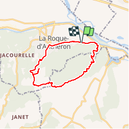
Trail Walking of 13.6 km to be discovered at Provence-Alpes-Côte d'Azur, Bouches-du-Rhône, La Roque-d'Anthéron. This trail is proposed by martilin.

Description

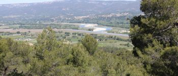
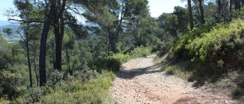
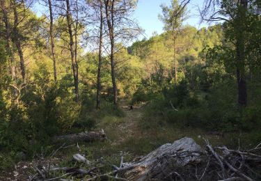
Une ballade très agréable dans les pins
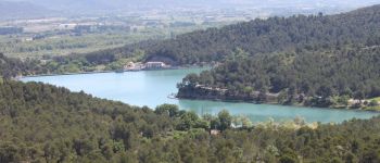
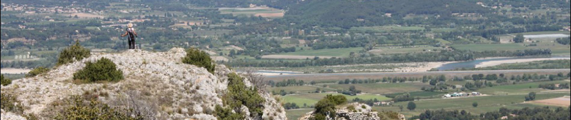
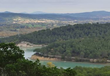
des points de vue magnifiques
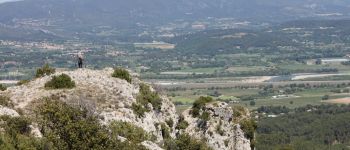
surtout ne pas manquer aller-retour au rocher de Castellas pour une vue sur la vallée de la Durance innoubliable

Elevation profile

Photos

Points of interest

Point of interest La Roque-d'Anthéron - La durance - Photo
martilin
LA ROQUE-D'ANTHÉRON 
Point of interest La Roque-d'Anthéron - Le chemin - Photo
martilin
LA ROQUE-D'ANTHÉRON 
Point of interest Rognes - Saint Christophe - Photo
martilin
Point of interest La Roque-d'Anthéron - rocher de Castellas - Photo
martilin
LA ROQUE-D'ANTHÉRON 

Positioning

Country:
France
Region :
Provence-Alpes-Côte d'Azur
Department/Province :
Bouches-du-Rhône
Municipality :
La Roque-d'Anthéron
Location:
Unknown
Start:(UTM)
687810 ; 4842833 (31T) N.

Trails nearby

Trail On foot La Roque-d'Anthéron - Chemin aménagé le long de la DURANCE - Photo
On foot
dominique dubroca

On foot

Very easy
(1)
La Roque-d'Anthéron, Provence-Alpes-Côte d'Azur, Bouches-du-Rhône, France
14 km | 14.9 km-effort
Unknown
No
Trail Walking Cadenet - Cadenet -Lourmarin - Photo
Walking

Walking

Very easy
(1)
Cadenet, Provence-Alpes-Côte d'Azur, Vaucluse, France
12.1 km | 15.3 km-effort
5h 43min
Yes
Trail Walking Lambesc - Chaine des Côtes - Photo
Walking
bryss

Walking

Medium
(1)
Lambesc, Provence-Alpes-Côte d'Azur, Bouches-du-Rhône, France
13.2 km | 17.9 km-effort
3h 48min
Yes
Trail Walking La Roque-d'Anthéron - Gambadous - La Roque d'Antheron - Photo
Walking
Taricot

Walking

Easy
(2)
La Roque-d'Anthéron, Provence-Alpes-Côte d'Azur, Bouches-du-Rhône, France
7.3 km | 10 km-effort
2h 30min
Yes
Trail Walking Rognes - Caire Val- les Costes -St Marcellin - Photo
Walking
Berpav

Walking

Medium
(1)
Rognes, Provence-Alpes-Côte d'Azur, Bouches-du-Rhône, France
8.6 km | 10.7 km-effort
2h 26min
Yes
Trail Walking La Roque-d'Anthéron - GB DURANCE+ CHÂTEAU DE JANSON  - Photo
Walking
Ghislaine Blanchet

Walking

Medium
La Roque-d'Anthéron, Provence-Alpes-Côte d'Azur, Bouches-du-Rhône, France
5.5 km | 6 km-effort
1h 22min
Yes
Trail Walking Cadenet - Cadenet Lourmarin Cadenet - Photo
Walking
jll7513

Walking

Easy
Cadenet, Provence-Alpes-Côte d'Azur, Vaucluse, France
10.5 km | 13.3 km-effort
3h 1min
Yes
Trail Walking Rognes - St Christophe-La Durance-Ponserot - Photo
Walking

Walking

Difficult
(3)
Rognes, Provence-Alpes-Côte d'Azur, Bouches-du-Rhône, France
12.2 km | 14.4 km-effort
3h 14min
Yes
Trail Walking Lambesc - Bastide blanche - Janet - Photo
Walking
Berpav

Walking

Medium
(2)
Lambesc, Provence-Alpes-Côte d'Azur, Bouches-du-Rhône, France
9.4 km | 12.6 km-effort
2h 51min
Yes


Close
My subscriptions