![](/images/other/stat-length.png)
![Trail Walking Sainte-Pazanne - La Beusse - Photo](https://media.geolcdn.com/t/1900/400/0c39b478-ba46-45f5-a403-3503d84dbc03.jpg&format=pjpeg&maxdim=2)
La Beusse
neoroll44
User
![Length](/images/other/stat-length.png)
![Max alt](https://static1.geolcdn.com/siteimages/upload/files/1508320355ic_sort_altitude_max_24dp.png)
![Uphill gradient](https://static1.geolcdn.com/siteimages/upload/files/1508320355ic_sort_den_pos_24dp.png)
![Km-Effort](/images/other/stat-length.png)
![Min alt](https://static1.geolcdn.com/siteimages/upload/files/1508320355ic_sort_altitude_min_24dp.png)
![Downhill gradient](https://static1.geolcdn.com/siteimages/upload/files/1508320355ic_sort_den_neg_24dp.png)
![Boucle](https://static1.geolcdn.com/siteimages/upload/files/16400158638029165_repeat_loop_refresh_sync_direction_icon.png)
![Walking](https://static1.geolcdn.com/sitytour/trail-icons/101.png)
2h00
Difficulty : Easy
![Scan this QR Code to open this trail in the SityTrail application](https://capi.geolives.com/qq0zvz2zws4bq2lad0pu/sitytour/trails/2735775/qr.png?size=200)
FREE GPS app for hiking
About
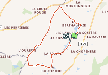
Trail Walking of 8.3 km to be discovered at Pays de la Loire, Loire-Atlantique, Sainte-Pazanne. This trail is proposed by neoroll44.
Description
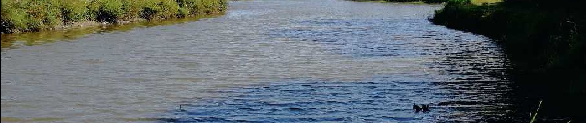
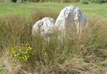
Découvrez l’étang de la Beusse, aménagé par les agriculteurs pour l’irrigation des cultures ainsi que les villages typiques au cœur du bocage.
Au départ du parking, gagnez l’étang et longez-le par la droite.
Empruntez la passerelle pour passer sur la digue et poursuivez votre
cheminement le long de l’étang.
Passez dans le village de la Bertaudrie puis traversez la route
communale. Continuez tout droit dans le chemin. Au bout de
celui-ci, tournez à gauche avant la route départementale et suivez
le chemin goudronné.
Traversez la route communale, puis continuez tout droit en
empruntant un chemin de terre sur 1.5 km. Tournez à gauche pour
rejoindre la route communale, parcourez-la sur 200 m et bifurquez
à droite le long du petit bois jusqu’au village de la Boutinière.
Tournez à gauche et poursuivez sur la route vers le village de la
Beusse. A l’entrée de celui-ci, prenez à droite et empruntez le chemin
entre les maisons pour rejoindre l’étang. Regagnez le point de départ
en longeant l’étang à droite.
Positioning
Comments
Trails nearby
![Trail On foot Saint-Hilaire-de-Chaléons - Circuit des Templiers - Photo](https://media.geolcdn.com/t/375/260/d2ec675e-afb6-4d2c-b141-de8dacdba4f4.jpeg&format=jpg&maxdim=2)
![On foot On foot](https://static1.geolcdn.com/sitytour/trail-icons/100.png)
On foot
![](/images/other/stat-length.png)
![](https://static1.geolcdn.com/siteimages/upload/files/16400158638029165_repeat_loop_refresh_sync_direction_icon.png)
![Trail On foot Villeneuve-en-Retz - Les roseaux et le bocage - Photo](https://media.geolcdn.com/t/375/260/c8f3ca36-d092-4724-80d2-115c2709d19a.jpeg&format=jpg&maxdim=2)
![On foot On foot](https://static1.geolcdn.com/sitytour/trail-icons/100.png)
On foot
![](/images/other/stat-length.png)
![](https://static1.geolcdn.com/siteimages/upload/files/16400158638029165_repeat_loop_refresh_sync_direction_icon.png)
![Trail On foot Villeneuve-en-Retz - Les Ajoncs - Photo](https://media.geolcdn.com/t/375/260/a75d8add-319e-469f-abc7-7f7c6664ec76.jpeg&format=jpg&maxdim=2)
![On foot On foot](https://static1.geolcdn.com/sitytour/trail-icons/100.png)
On foot
![](/images/other/stat-length.png)
![](https://static1.geolcdn.com/siteimages/upload/files/16400158638029165_repeat_loop_refresh_sync_direction_icon.png)
![Trail Walking Sainte-Pazanne - Ste Pazanne_Coulée_Aqueduc - Photo](https://media.geolcdn.com/t/375/260/ext.jpg?maxdim=2&url=https%3A%2F%2Fservices.sitytrail.com%2FGeolivesWS%2FDownloadMedia.ashx%3FTrailID%3D580011%26Media%3D525ac128-9a89-4ccf-890c-fc7a28420256.jpg)
![Walking Walking](https://static1.geolcdn.com/sitytour/trail-icons/101.png)
Walking
![](/images/other/stat-length.png)
![](https://static1.geolcdn.com/siteimages/upload/files/16400158638029165_repeat_loop_refresh_sync_direction_icon.png)
![Trail Walking Sainte-Pazanne - la beusse - Photo](https://media.geolcdn.com/t/375/260/ext.jpg?maxdim=2&url=https%3A%2F%2Fstatic1.geolcdn.com%2Fsiteimages%2Fupload%2Ffiles%2F1553511878bg_sport_marche.png)
![Walking Walking](https://static1.geolcdn.com/sitytour/trail-icons/101.png)
Walking
![](/images/other/stat-length.png)
![](https://static1.geolcdn.com/siteimages/upload/files/16400158638029165_repeat_loop_refresh_sync_direction_icon.png)
![Trail sport Sainte-Pazanne - 2022-10-18_18h51m43_SityTrail - 2295126 - etang-de-la-beusse - Photo](https://media.geolcdn.com/t/375/260/ext.jpg?maxdim=2&url=https%3A%2F%2Fsecurestorage.geolives.com%2Fsitytour%2Ftrail-bg%2Fdefault.jpg)
sport
![](/images/other/stat-length.png)
![](https://static1.geolcdn.com/siteimages/upload/files/16400158638029165_repeat_loop_refresh_sync_direction_icon.png)
![Trail Walking Villeneuve-en-Retz - Villeneuve-en-Retz Randonnée - Photo](https://media.geolcdn.com/t/375/260/ext.jpg?maxdim=2&url=https%3A%2F%2Fstatic1.geolcdn.com%2Fsiteimages%2Fupload%2Ffiles%2F1553511878bg_sport_marche.png)
![Walking Walking](https://static1.geolcdn.com/sitytour/trail-icons/101.png)
Walking
![](/images/other/stat-length.png)
![](https://static1.geolcdn.com/siteimages/upload/files/16400158638029165_repeat_loop_refresh_sync_direction_icon.png)
![Trail Walking Sainte-Pazanne - Ste Pazanne - Photo](https://media.geolcdn.com/t/375/260/ext.jpg?maxdim=2&url=https%3A%2F%2Fstatic1.geolcdn.com%2Fsiteimages%2Fupload%2Ffiles%2F1553511878bg_sport_marche.png)
![Walking Walking](https://static1.geolcdn.com/sitytour/trail-icons/101.png)
Walking
![](/images/other/stat-length.png)
![](https://static1.geolcdn.com/siteimages/upload/files/16400158638029165_repeat_loop_refresh_sync_direction_icon.png)