Trail Road bike Saint-Laurent-de-Mure - velo1 - Photo
© OpenStreetMap contributors
Length
Length
26 km
Max alt
Max alt
367 m
Uphill gradient
Uphill gradient
247 m
Km-Effort
Km-Effort  
30 km
Min alt
Min alt
269 m
Downhill gradient
Downhill gradient
243 m
Boucle
Boucle
No
Creation date :
2021-04-04 08:03:25.873
Updated on :
2021-04-04 09:33:16.603

(0 Reviews)

Road bike
Road bike
1h27
Difficulty : Medium

Scan this QR Code to open this trail in the SityTrail application

FREE GPS app for hiking

Logo SityTrail SityTrail

IGN / Geographical institutes

Download SityTrail from the App Store Download SityTrail from Google Play

Logo SityTrail SityTrail World

The world is yours!

Download SityTrail from the App Store Download SityTrail from Google Play Download SityTrail on Huawei AppGallery

About

Trail Road bike of 26 km to be discovered at Auvergne-Rhône-Alpes, Rhône, Saint-Laurent-de-Mure. This trail is proposed by alex69820.

Elevation profile

Positioning

Country:
France
Region :
Auvergne-Rhône-Alpes
Department/Province :
Rhône
Municipality :
Saint-Laurent-de-Mure
Location:
Unknown
Start:(UTM)
659152 ; 5060474 (31T) N.

Trails nearby

Trail Walking Toussieu - 69 Toussieu poypes 2 vallons 21km 420m - Photo
Walking
SyMA

Walking

Medium
Toussieu, Auvergne-Rhône-Alpes, Rhône, France
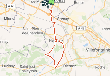
21 km | 27 km-effort
5h 54min
Yes
Trail Walking Saint-Pierre-de-Chandieu - 69-Saint Pierre de Chandieu 17km 400m MAI 2020 - Photo
Walking
SyMA

Walking

Easy
Saint-Pierre-de-Chandieu, Auvergne-Rhône-Alpes, Rhône, France
17.4 km | 23 km-effort
4h 48min
Yes
Trail Walking Saint-Pierre-de-Chandieu - 69 Saint Pierre Chandieu 2 17km 380m - Photo
Walking
SyMA

Walking

Easy
Saint-Pierre-de-Chandieu, Auvergne-Rhône-Alpes, Rhône, France
17.4 km | 23 km-effort
4h 48min
Yes
Trail Walking Saint-Pierre-de-Chandieu - 69-Saint Pierre de chandieu 18km 400m - Photo
Walking
SyMA

Walking

Easy
Saint-Pierre-de-Chandieu, Auvergne-Rhône-Alpes, Rhône, France
17.6 km | 23 km-effort
3h 50min
Yes
Trail Mountain bike Saint-Quentin-Fallavier - La St Quentinoise 2008 - Photo
Mountain bike
tracegps

Mountain bike

Difficult
Saint-Quentin-Fallavier, Auvergne-Rhône-Alpes, Isère, France
47 km | 60 km-effort
4h 0min
Yes
Trail Horseback riding Saint-Bonnet-de-Mure - tttr - Photo
Horseback riding
lau74

Horseback riding

Very easy
Saint-Bonnet-de-Mure, Auvergne-Rhône-Alpes, Rhône, France
121 km | 162 km-effort
15h 4min
No
Trail Plane Colombier-Saugnieu - Barcelone - Photo
Plane
momogoofy

Plane

Very easy
Colombier-Saugnieu, Auvergne-Rhône-Alpes, Rhône, France
640 km | 821 km-effort
1h 5min
No
Trail Mountain bike Toussieu - toussieu champie - Photo
Mountain bike
Regine@0809

Mountain bike

Medium
(1)
Toussieu, Auvergne-Rhône-Alpes, Rhône, France
24 km | 29 km-effort
1h 35min
Yes
Trail Walking Saint-Pierre-de-Chandieu - rajat2 - Photo
Walking
Morin thierry

Walking

Medium
Saint-Pierre-de-Chandieu, Auvergne-Rhône-Alpes, Rhône, France
8 km | 9.5 km-effort
1h 50min
Yes


Close
My subscriptions