![](/images/other/stat-length.png)
![Trail Walking Saou - les trois Becs - Photo](https://media.geolcdn.com/t/1900/400/ext.pjpeg?maxdim=2&url=https%3A%2F%2Fstatic1.geolcdn.com%2Fsiteimages%2Fupload%2Ffiles%2F1553511878bg_sport_marche.png)
les trois Becs
hugo26
User
![Length](/images/other/stat-length.png)
Length
18.2 km
![Max alt](https://static1.geolcdn.com/siteimages/upload/files/1508320355ic_sort_altitude_max_24dp.png)
Max alt
1547 m
![Uphill gradient](https://static1.geolcdn.com/siteimages/upload/files/1508320355ic_sort_den_pos_24dp.png)
Uphill gradient
1248 m
![Km-Effort](/images/other/stat-length.png)
Km-Effort
35 km
![Min alt](https://static1.geolcdn.com/siteimages/upload/files/1508320355ic_sort_altitude_min_24dp.png)
Min alt
471 m
![Downhill gradient](https://static1.geolcdn.com/siteimages/upload/files/1508320355ic_sort_den_neg_24dp.png)
Downhill gradient
1249 m
![Boucle](https://static1.geolcdn.com/siteimages/upload/files/16400158638029165_repeat_loop_refresh_sync_direction_icon.png)
Boucle
Yes
Creation date :
2021-03-28 16:22:35.479
Updated on :
2021-03-28 16:30:23.468
![Walking](https://static1.geolcdn.com/sitytour/trail-icons/101.png)
7h54
Difficulty : Very difficult
![Scan this QR Code to open this trail in the SityTrail application](https://capi.geolives.com/qq0zvz2zws4bq2lad0pu/sitytour/trails/2725715/qr.png?size=200)
FREE GPS app for hiking
About
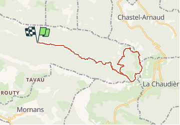
Trail Walking of 18.2 km to be discovered at Auvergne-Rhône-Alpes, Drôme, Saou. This trail is proposed by hugo26.
Description
Depuis Saou Parking de l'auberge des Dauphins . Piste au départ puis sentier ensuite jusqu'au pré de l'âne .Bonne montée pour le pas de la siarre . De là forte monté pour le le Veyou. Bonne rando avec un temps magnifique le 28/03/20
Positioning
Country:
France
Region :
Auvergne-Rhône-Alpes
Department/Province :
Drôme
Municipality :
Saou
Location:
Unknown
Start:(Dec)
Start:(UTM)
668898 ; 4946520 (31T) N.
Comments
Trails nearby
![Trail Walking Francillon-sur-Roubion - Balade à francillon sur roubion - description et photos - Photo](https://media.geolcdn.com/t/375/260/ext.jpg?maxdim=2&url=https%3A%2F%2Fservices.sitytrail.com%2FGeolivesWS%2FDownloadMedia.ashx%3FTrailID%3D656838%26Media%3Dfix__20161106144505.jpg)
![Walking Walking](https://static1.geolcdn.com/sitytour/trail-icons/101.png)
Balade à francillon sur roubion - description et photos
Walking
Easy
(1)
Francillon-sur-Roubion,
Auvergne-Rhône-Alpes,
Drôme,
France
![](/images/other/stat-length.png)
5 km | 6.7 km-effort
1h 36min
![](https://static1.geolcdn.com/siteimages/upload/files/16400158638029165_repeat_loop_refresh_sync_direction_icon.png)
Yes
![Trail Walking Saou - roche Colombe - Photo](https://media.geolcdn.com/t/375/260/ext.jpg?maxdim=2&url=https%3A%2F%2Fservices.sitytrail.com%2FGeolivesWS%2FDownloadMedia.ashx%3FTrailID%3D528694%26Media%3Dfix__20160221163100.jpg)
![Walking Walking](https://static1.geolcdn.com/sitytour/trail-icons/101.png)
roche Colombe
Walking
Medium
(1)
Saou,
Auvergne-Rhône-Alpes,
Drôme,
France
![](/images/other/stat-length.png)
10.9 km | 16.8 km-effort
3h 58min
![](https://static1.geolcdn.com/siteimages/upload/files/16400158638029165_repeat_loop_refresh_sync_direction_icon.png)
Yes
![Trail Walking Saou - saou.les 3 becs - Photo](https://media.geolcdn.com/t/375/260/ext.jpg?maxdim=2&url=https%3A%2F%2Fservices.sitytrail.com%2FGeolivesWS%2FDownloadMedia.ashx%3FTrailID%3D329039%26Media%3Dfix__20140719140834.jpg)
![Walking Walking](https://static1.geolcdn.com/sitytour/trail-icons/101.png)
saou.les 3 becs
Walking
Difficult
(3)
Saou,
Auvergne-Rhône-Alpes,
Drôme,
France
![](/images/other/stat-length.png)
22 km | 40 km-effort
6h 46min
![](https://static1.geolcdn.com/siteimages/upload/files/16400158638029165_repeat_loop_refresh_sync_direction_icon.png)
Yes
![Trail Walking Piégros-la-Clastre - Pas de Lauzen Col de la Chaudière - Photo](https://media.geolcdn.com/t/375/260/ext.jpg?maxdim=2&url=https%3A%2F%2Fservices.sitytrail.com%2FGeolivesWS%2FDownloadMedia.ashx%3FTrailID%3D141403%26Media%3D20120724110938.jpeg)
![Walking Walking](https://static1.geolcdn.com/sitytour/trail-icons/101.png)
Pas de Lauzen Col de la Chaudière
Walking
Very difficult
(1)
Piégros-la-Clastre,
Auvergne-Rhône-Alpes,
Drôme,
France
![](/images/other/stat-length.png)
19.6 km | 42 km-effort
7h 36min
![](https://static1.geolcdn.com/siteimages/upload/files/16400158638029165_repeat_loop_refresh_sync_direction_icon.png)
No
![Trail Walking Saou - Les 3 Becs, le Veyou, le Signal et Rochecourbe - Photo](https://media.geolcdn.com/t/375/260/ext.jpg?maxdim=2&url=https%3A%2F%2Fservices.sitytrail.com%2FGeolivesWS%2FDownloadMedia.ashx%3FTrailID%3D103158%26Media%3D4975_2.jpg)
![Walking Walking](https://static1.geolcdn.com/sitytour/trail-icons/101.png)
Les 3 Becs, le Veyou, le Signal et Rochecourbe
Walking
Difficult
(3)
Saou,
Auvergne-Rhône-Alpes,
Drôme,
France
![](/images/other/stat-length.png)
18.5 km | 36 km-effort
8h 0min
![](https://static1.geolcdn.com/siteimages/upload/files/16400158638029165_repeat_loop_refresh_sync_direction_icon.png)
Yes
![Trail Walking Mornans - 2024-11-19_11h34m34_FFRandonnée-Serre_Antoine - Photo](https://media.geolcdn.com/t/375/260/aebe72e3-9e3b-4ceb-b487-16517306d02c.jpg&format=jpg&maxdim=2)
![Walking Walking](https://static1.geolcdn.com/sitytour/trail-icons/101.png)
2024-11-19_11h34m34_FFRandonnée-Serre_Antoine
Walking
Difficult
Mornans,
Auvergne-Rhône-Alpes,
Drôme,
France
![](/images/other/stat-length.png)
11.4 km | 17.4 km-effort
3h 57min
![](https://static1.geolcdn.com/siteimages/upload/files/16400158638029165_repeat_loop_refresh_sync_direction_icon.png)
Yes
![Trail Walking Saou - 26 roche colombe zel - Photo](https://media.geolcdn.com/t/375/260/ade4c229-22f9-4630-ba38-8a3eb6b452f5.jpg&format=jpg&maxdim=2)
![Walking Walking](https://static1.geolcdn.com/sitytour/trail-icons/101.png)
26 roche colombe zel
Walking
Medium
Saou,
Auvergne-Rhône-Alpes,
Drôme,
France
![](/images/other/stat-length.png)
13.5 km | 23 km-effort
6h 47min
![](https://static1.geolcdn.com/siteimages/upload/files/16400158638029165_repeat_loop_refresh_sync_direction_icon.png)
No
![Trail Walking Saint-Sauveur-en-Diois - saint sauveur en diois - Photo](https://media.geolcdn.com/t/375/260/571ebd87-a7e9-4b87-af12-17cecb59278a.jpg&format=jpg&maxdim=2)
![Walking Walking](https://static1.geolcdn.com/sitytour/trail-icons/101.png)
saint sauveur en diois
Walking
Very easy
Saint-Sauveur-en-Diois,
Auvergne-Rhône-Alpes,
Drôme,
France
![](/images/other/stat-length.png)
5 km | 6.7 km-effort
1h 46min
![](https://static1.geolcdn.com/siteimages/upload/files/16400158638029165_repeat_loop_refresh_sync_direction_icon.png)
Yes
![Trail Walking Aubenasson - saint Michel Aubenasson - Photo](https://media.geolcdn.com/t/375/260/9cfb9e95-478d-41e2-9a6e-6de46d17856a.jpg&format=jpg&maxdim=2)
![Walking Walking](https://static1.geolcdn.com/sitytour/trail-icons/101.png)
saint Michel Aubenasson
Walking
Medium
Aubenasson,
Auvergne-Rhône-Alpes,
Drôme,
France
![](/images/other/stat-length.png)
19.7 km | 24 km-effort
3h 45min
![](https://static1.geolcdn.com/siteimages/upload/files/16400158638029165_repeat_loop_refresh_sync_direction_icon.png)
No