Trail Mountain bike Le Teil - rando-le teil 2014 - Photo
 royco
royco

User

© OpenStreetMap contributors
Length
Length
46 km
Max alt
Max alt
439 m
Uphill gradient
Uphill gradient
1216 m
Km-Effort
Km-Effort  
62 km
Min alt
Min alt
69 m
Downhill gradient
Downhill gradient
1217 m
Boucle
Boucle
Yes
Creation date :
2014-12-10 00:00:00.0
Updated on :
2014-12-10 00:00:00.0

(1 Reviews)

Mountain bike
Mountain bike
3h57
Difficulty : Difficult

Scan this QR Code to open this trail in the SityTrail application

FREE GPS app for hiking

Logo SityTrail SityTrail

IGN / Geographical institutes

Download SityTrail from the App Store Download SityTrail from Google Play

Logo SityTrail SityTrail World

The world is yours!

Download SityTrail from the App Store Download SityTrail from Google Play Download SityTrail on Huawei AppGallery

About

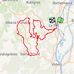
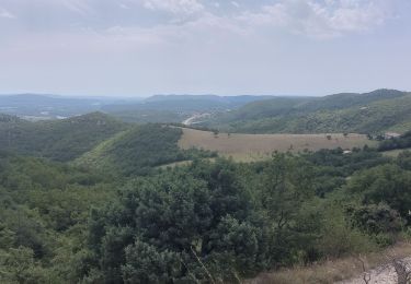
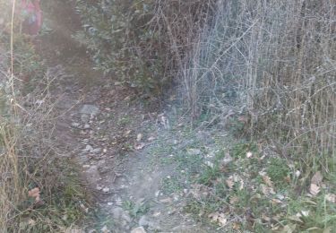
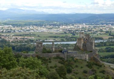
Trail Mountain bike of 46 km to be discovered at Auvergne-Rhône-Alpes, Ardèche, Le Teil. This trail is proposed by royco.

Elevation profile

Positioning

Country:
France
Region :
Auvergne-Rhône-Alpes
Department/Province :
Ardèche
Municipality :
Le Teil
Location:
Unknown
Start:(UTM)
634138 ; 4934037 (31T) N.

Comments

Please log in to post a review or rate the element


Pratique et bien mais le téléchargement des cartes ne permet pas toujours un fonctionnement hors ligne satisfaisant.


Trails nearby

Trail Walking Rochemaure - Randonnée entre Rochemaure et Aubignas - Photo
Walking
tracegps

Walking

Difficult
(2)
Rochemaure, Auvergne-Rhône-Alpes, Ardèche, France
16.8 km | 26 km-effort
5h 30min
Yes
Trail Walking Rochemaure - Rochemaure - Photo
Walking
tracegps

Walking

Medium
(3)
Rochemaure, Auvergne-Rhône-Alpes, Ardèche, France
8.8 km | 13.6 km-effort
3h 0min
Yes
Trail Walking Le Teil - 07 le teil - Photo
Walking
GUIDE
randodyssée

Walking

Medium
Le Teil, Auvergne-Rhône-Alpes, Ardèche, France
16.1 km | 23 km-effort
6h 20min
Yes
Trail Walking Aubignas - Aubignas Chenavari 17km - Photo
Walking
GUIDE
thonyc

Walking

Difficult
Aubignas, Auvergne-Rhône-Alpes, Ardèche, France
16.5 km | 25 km-effort
5h 20min
Yes
Trail Nordic walking Montélimar - 20191002 MN Hymalaya - Photo
Nordic walking
Havani

Nordic walking

Very easy
(1)
Montélimar, Auvergne-Rhône-Alpes, Drôme, France
7.7 km | 8.4 km-effort
1h 49min
Yes
Trail Mountain bike Aubignas - Aubignas tour coiron all mountain - Photo
Mountain bike
royco

Mountain bike

Difficult
(2)
Aubignas, Auvergne-Rhône-Alpes, Ardèche, France
20 km | 30 km-effort
1h 54min
No
Trail Walking Rochemaure - tour du chenavari - Photo
Walking
romdu

Walking

Medium
(1)
Rochemaure, Auvergne-Rhône-Alpes, Ardèche, France
6.3 km | 9.5 km-effort
2h 0min
Yes
Trail Walking Ancône - rochemeaure pic de chenavarie  - Photo
Walking
Joel26400

Walking

Very difficult
Ancône, Auvergne-Rhône-Alpes, Drôme, France
15.4 km | 22 km-effort
4h 51min
Yes
Trail Walking Saint-Thomé - saint thomé - Photo
Walking
Vero7684

Walking

Medium
Saint-Thomé, Auvergne-Rhône-Alpes, Ardèche, France
13.9 km | 22 km-effort
5h 11min
Yes


Close
My subscriptions