![](/images/other/stat-length.png)
![Trail On foot Saint-Michel-les-Portes - Au tour (sic !) du Goutaroux et de l'Aubeyron - Photo](https://media.geolcdn.com/t/1900/400/ext.pjpeg?maxdim=2&url=https%3A%2F%2Fstatic1.geolcdn.com%2Fsiteimages%2Fupload%2Ffiles%2F1545311037marcheuse_200dpi.jpg)
Au tour (sic !) du Goutaroux et de l'Aubeyron
Chafoin
User
![Length](/images/other/stat-length.png)
Length
11.4 km
![Max alt](https://static1.geolcdn.com/siteimages/upload/files/1508320355ic_sort_altitude_max_24dp.png)
Max alt
1246 m
![Uphill gradient](https://static1.geolcdn.com/siteimages/upload/files/1508320355ic_sort_den_pos_24dp.png)
Uphill gradient
587 m
![Km-Effort](/images/other/stat-length.png)
Km-Effort
19.3 km
![Min alt](https://static1.geolcdn.com/siteimages/upload/files/1508320355ic_sort_altitude_min_24dp.png)
Min alt
817 m
![Downhill gradient](https://static1.geolcdn.com/siteimages/upload/files/1508320355ic_sort_den_neg_24dp.png)
Downhill gradient
585 m
![Boucle](https://static1.geolcdn.com/siteimages/upload/files/16400158638029165_repeat_loop_refresh_sync_direction_icon.png)
Boucle
Yes
Creation date :
2021-03-26 03:54:30.781
Updated on :
2021-03-26 04:03:37.088
![On foot](https://static1.geolcdn.com/sitytour/trail-icons/100.png)
4h22
Difficulty : Medium
![Scan this QR Code to open this trail in the SityTrail application](https://capi.geolives.com/qq0zvz2zws4bq2lad0pu/sitytour/trails/2721336/qr.png?size=200)
FREE GPS app for hiking
About
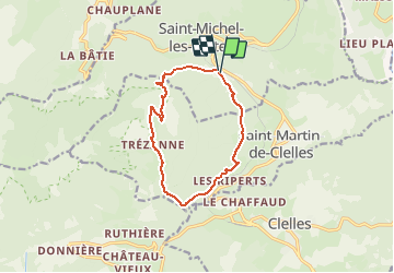
Trail On foot of 11.4 km to be discovered at Auvergne-Rhône-Alpes, Isère, Saint-Michel-les-Portes. This trail is proposed by Chafoin.
Description
Des Granges ( 819 m) ,puis les Blaches ,l'Arrent ,Chalabaud , Maison Dame le pas de l'Escalier (978 m) ,Trézanne ( 1012 m) ,Col de Papavet (1326 m)et retour aux Granges
11 km ou 19 en Km Effort et 600 m environ de D ou 4 h22 de marchr
Positioning
Country:
France
Region :
Auvergne-Rhône-Alpes
Department/Province :
Isère
Municipality :
Saint-Michel-les-Portes
Location:
Unknown
Start:(Dec)
Start:(UTM)
705488 ; 4970798 (31T) N.
Comments
Trails nearby
![Trail Walking Gresse-en-Vercors - Quinquambaye - crête du Brisou - Photo](https://media.geolcdn.com/t/375/260/ext.jpg?maxdim=2&url=https%3A%2F%2Fmedia.geolcdn.com%2Ff%2F686aed71-19ef-4a34-8333-a2b65dd9c4d5.jpg)
![Walking Walking](https://static1.geolcdn.com/sitytour/trail-icons/101.png)
Quinquambaye - crête du Brisou
Walking
Medium
(1)
Gresse-en-Vercors,
Auvergne-Rhône-Alpes,
Isère,
France
![](/images/other/stat-length.png)
12.1 km | 23 km-effort
6h 28min
![](https://static1.geolcdn.com/siteimages/upload/files/16400158638029165_repeat_loop_refresh_sync_direction_icon.png)
Yes
![Trail Walking Gresse-en-Vercors - Traversée du Rocher du Baconnet - Photo](https://media.geolcdn.com/t/375/260/ext.jpg?maxdim=2&url=https%3A%2F%2Fservices.sitytrail.com%2FGeolivesWS%2FDownloadMedia.ashx%3FTrailID%3D105962%26Media%3D10040_1.jpg)
![Walking Walking](https://static1.geolcdn.com/sitytour/trail-icons/101.png)
Traversée du Rocher du Baconnet
Walking
Easy
(2)
Gresse-en-Vercors,
Auvergne-Rhône-Alpes,
Isère,
France
![](/images/other/stat-length.png)
10.7 km | 18.9 km-effort
5h 0min
![](https://static1.geolcdn.com/siteimages/upload/files/16400158638029165_repeat_loop_refresh_sync_direction_icon.png)
Yes
![Trail Walking Gresse-en-Vercors - le grand veymont depuis gresse en vercors et par le pas de la ville - Photo](https://media.geolcdn.com/t/375/260/ext.jpg?maxdim=2&url=https%3A%2F%2Fstatic1.geolcdn.com%2Fsiteimages%2Fupload%2Ffiles%2F1553511878bg_sport_marche.png)
![Walking Walking](https://static1.geolcdn.com/sitytour/trail-icons/101.png)
le grand veymont depuis gresse en vercors et par le pas de la ville
Walking
Medium
(1)
Gresse-en-Vercors,
Auvergne-Rhône-Alpes,
Isère,
France
![](/images/other/stat-length.png)
10.9 km | 25 km-effort
4h 53min
![](https://static1.geolcdn.com/siteimages/upload/files/16400158638029165_repeat_loop_refresh_sync_direction_icon.png)
Yes
![Trail Equestrian Roissard - Trieves - Devoluy - Photo](https://media.geolcdn.com/t/375/260/ext.jpg?maxdim=2&url=https%3A%2F%2Fmedia.geolcdn.com%2Ff%2F532091fd-ff63-40b6-9790-4b260fef3e51.jpg)
![Equestrian Equestrian](https://static1.geolcdn.com/sitytour/trail-icons/300.png)
Trieves - Devoluy
Equestrian
Difficult
Roissard,
Auvergne-Rhône-Alpes,
Isère,
France
![](/images/other/stat-length.png)
131 km | 200 km-effort
Unknown
![](https://static1.geolcdn.com/siteimages/upload/files/16400158638029165_repeat_loop_refresh_sync_direction_icon.png)
Yes
![Trail Walking Gresse-en-Vercors - Le grand veymont 2341 m - Photo](https://media.geolcdn.com/t/375/260/ext.jpg?maxdim=2&url=https%3A%2F%2Fmedia.geolcdn.com%2Ff%2F1c0de7b0-54c4-46b0-a110-3cbad7cf7845.jpg)
![Walking Walking](https://static1.geolcdn.com/sitytour/trail-icons/101.png)
Le grand veymont 2341 m
Walking
Very difficult
Gresse-en-Vercors,
Auvergne-Rhône-Alpes,
Isère,
France
![](/images/other/stat-length.png)
18 km | 38 km-effort
4h 18min
![](https://static1.geolcdn.com/siteimages/upload/files/16400158638029165_repeat_loop_refresh_sync_direction_icon.png)
Yes
![Trail Walking Gresse-en-Vercors - Pas des Baschassons - Carrière romaine - Pas de la Selle - Photo](https://media.geolcdn.com/t/375/260/ext.jpg?maxdim=2&url=https%3A%2F%2Fmedia.geolcdn.com%2Ff%2F56b0bd40-9412-42bf-9504-9a813d0bd429.jpg)
![Walking Walking](https://static1.geolcdn.com/sitytour/trail-icons/101.png)
Pas des Baschassons - Carrière romaine - Pas de la Selle
Walking
Difficult
Gresse-en-Vercors,
Auvergne-Rhône-Alpes,
Isère,
France
![](/images/other/stat-length.png)
16.9 km | 31 km-effort
7h 0min
![](https://static1.geolcdn.com/siteimages/upload/files/16400158638029165_repeat_loop_refresh_sync_direction_icon.png)
Yes
![Trail Walking Saint-Martin-de-Clelles - Esclops Trièves tour du goutaroux - Photo](https://media.geolcdn.com/t/375/260/ext.jpg?maxdim=2&url=https%3A%2F%2Fmedia.geolcdn.com%2Ff%2F92348273-d153-4731-a4d8-1976f500b0d9.jpg)
![Walking Walking](https://static1.geolcdn.com/sitytour/trail-icons/101.png)
Esclops Trièves tour du goutaroux
Walking
Medium
Saint-Martin-de-Clelles,
Auvergne-Rhône-Alpes,
Isère,
France
![](/images/other/stat-length.png)
11 km | 18.8 km-effort
4h 58min
![](https://static1.geolcdn.com/siteimages/upload/files/16400158638029165_repeat_loop_refresh_sync_direction_icon.png)
Yes
![Trail Walking Chichilianne - Esclops Trièves Tour du Mont Aiguille - Photo](https://media.geolcdn.com/t/375/260/ext.jpg?maxdim=2&url=https%3A%2F%2Fmedia.geolcdn.com%2Ff%2F367f316d-8d4c-43ed-bbe2-7016bd24ae42.jpg)
![Walking Walking](https://static1.geolcdn.com/sitytour/trail-icons/101.png)
Esclops Trièves Tour du Mont Aiguille
Walking
Difficult
Chichilianne,
Auvergne-Rhône-Alpes,
Isère,
France
![](/images/other/stat-length.png)
16.6 km | 32 km-effort
7h 38min
![](https://static1.geolcdn.com/siteimages/upload/files/16400158638029165_repeat_loop_refresh_sync_direction_icon.png)
Yes
![Trail Snowshoes Gresse-en-Vercors - Gresse en Vercors :pas du Serpaton-Rocher du Baconnet-Uclaire-pas du Bru - Photo](https://media.geolcdn.com/t/375/260/ext.jpg?maxdim=2&url=https%3A%2F%2Fmedia.geolcdn.com%2Ff%2Fee788aea-1c66-4671-8820-022e129ab489.jpg)
![Snowshoes Snowshoes](https://static1.geolcdn.com/sitytour/trail-icons/504.png)
Gresse en Vercors :pas du Serpaton-Rocher du Baconnet-Uclaire-pas du Bru
Snowshoes
Medium
Gresse-en-Vercors,
Auvergne-Rhône-Alpes,
Isère,
France
![](/images/other/stat-length.png)
10.4 km | 18.2 km-effort
3h 36min
![](https://static1.geolcdn.com/siteimages/upload/files/16400158638029165_repeat_loop_refresh_sync_direction_icon.png)
Yes