![](/images/other/stat-length.png)
![Trail Walking Aix-les-Bains - SityTrail - CORSUET: FORET DE CORSUET - GROTTE AUX FEES via belvédère et croix de Corsuet - Photo](https://media.geolcdn.com/t/1900/400/ext.pjpeg?maxdim=2&url=https%3A%2F%2Fstatic1.geolcdn.com%2Fsiteimages%2Fupload%2Ffiles%2F1553511878bg_sport_marche.png)
SityTrail - CORSUET: FORET DE CORSUET - GROTTE AUX FEES via belvédère et croix de Corsuet
djeepee74
User
![Length](/images/other/stat-length.png)
Length
7.7 km
![Max alt](https://static1.geolcdn.com/siteimages/upload/files/1508320355ic_sort_altitude_max_24dp.png)
Max alt
646 m
![Uphill gradient](https://static1.geolcdn.com/siteimages/upload/files/1508320355ic_sort_den_pos_24dp.png)
Uphill gradient
338 m
![Km-Effort](/images/other/stat-length.png)
Km-Effort
12.2 km
![Min alt](https://static1.geolcdn.com/siteimages/upload/files/1508320355ic_sort_altitude_min_24dp.png)
Min alt
358 m
![Downhill gradient](https://static1.geolcdn.com/siteimages/upload/files/1508320355ic_sort_den_neg_24dp.png)
Downhill gradient
337 m
![Boucle](https://static1.geolcdn.com/siteimages/upload/files/16400158638029165_repeat_loop_refresh_sync_direction_icon.png)
Boucle
Yes
Creation date :
2021-03-25 09:09:08.98
Updated on :
2021-04-03 18:27:05.416
![Walking](https://static1.geolcdn.com/sitytour/trail-icons/101.png)
2h45
Difficulty : Easy
![Scan this QR Code to open this trail in the SityTrail application](https://capi.geolives.com/qq0zvz2zws4bq2lad0pu/sitytour/trails/2720266/qr.png?size=200)
FREE GPS app for hiking
About
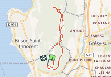
Trail Walking of 7.7 km to be discovered at Auvergne-Rhône-Alpes, Savoy, Aix-les-Bains. This trail is proposed by djeepee74.
Description
BOUCLE... live 20210322
Départ parking central.
Retour par la ferme Raymond, chemin de la montagne... puis chemin des perdrix.
Positioning
Country:
France
Region :
Auvergne-Rhône-Alpes
Department/Province :
Savoy
Municipality :
Aix-les-Bains
Location:
Unknown
Start:(Dec)
Start:(UTM)
725779 ; 5066270 (31T) N.
Comments
Trails nearby
![Trail Walking Brison-Saint-Innocent - La Croix de Meyrieu, retour par la Grotte des Fées, depuis les Combes - Photo](https://media.geolcdn.com/t/375/260/ext.jpg?maxdim=2&url=https%3A%2F%2Fservices.sitytrail.com%2FGeolivesWS%2FDownloadMedia.ashx%3FTrailID%3D317495%26Media%3D16730_1.jpg)
![Walking Walking](https://static1.geolcdn.com/sitytour/trail-icons/101.png)
La Croix de Meyrieu, retour par la Grotte des Fées, depuis les Combes
Walking
Easy
(2)
Brison-Saint-Innocent,
Auvergne-Rhône-Alpes,
Savoy,
France
![](/images/other/stat-length.png)
8.5 km | 14.8 km-effort
3h 30min
![](https://static1.geolcdn.com/siteimages/upload/files/16400158638029165_repeat_loop_refresh_sync_direction_icon.png)
Yes
![Trail Mountain bike Aix-les-Bains - Randolac 2008 - Epine Chat Chambotte - Photo](https://media.geolcdn.com/t/375/260/ext.jpg?maxdim=2&url=https%3A%2F%2Fservices.sitytrail.com%2FGeolivesWS%2FDownloadMedia.ashx%3FTrailID%3D102831%26Media%3D3994_2.jpg)
![Mountain bike Mountain bike](https://static1.geolcdn.com/sitytour/trail-icons/202.png)
Randolac 2008 - Epine Chat Chambotte
Mountain bike
Very difficult
(1)
Aix-les-Bains,
Auvergne-Rhône-Alpes,
Savoy,
France
![](/images/other/stat-length.png)
64 km | 94 km-effort
7h 0min
![](https://static1.geolcdn.com/siteimages/upload/files/16400158638029165_repeat_loop_refresh_sync_direction_icon.png)
Yes
![Trail Walking Brison-Saint-Innocent - Grotte des fées, Croix de Meyrieu, Mont Corsuet 843m 1.7.24 - Photo](https://media.geolcdn.com/t/375/260/40c03b1e-7ecc-48c9-b0a4-5c8c250e48e1.jpg&format=jpg&maxdim=2)
![Walking Walking](https://static1.geolcdn.com/sitytour/trail-icons/101.png)
Grotte des fées, Croix de Meyrieu, Mont Corsuet 843m 1.7.24
Walking
Medium
Brison-Saint-Innocent,
Auvergne-Rhône-Alpes,
Savoy,
France
![](/images/other/stat-length.png)
13.5 km | 22 km-effort
4h 30min
![](https://static1.geolcdn.com/siteimages/upload/files/16400158638029165_repeat_loop_refresh_sync_direction_icon.png)
Yes
![Trail Electric bike Aix-les-Bains - Aix les bains tour lac de Bourget abbaye Hautecombes - Photo](https://media.geolcdn.com/t/375/260/6de4fae3-0815-4d48-bb94-d895cfa7b1bb.jpg&format=jpg&maxdim=2)
![Electric bike Electric bike](https://static1.geolcdn.com/sitytour/trail-icons/205.png)
Aix les bains tour lac de Bourget abbaye Hautecombes
Electric bike
Medium
Aix-les-Bains,
Auvergne-Rhône-Alpes,
Savoy,
France
![](/images/other/stat-length.png)
66 km | 85 km-effort
5h 8min
![](https://static1.geolcdn.com/siteimages/upload/files/16400158638029165_repeat_loop_refresh_sync_direction_icon.png)
Yes
![Trail Walking Mouxy - Sentier du Perthuiset - Photo](https://media.geolcdn.com/t/375/260/ext.jpg?maxdim=2&url=https%3A%2F%2Fstatic1.geolcdn.com%2Fsiteimages%2Fupload%2Ffiles%2F1553511878bg_sport_marche.png)
![Walking Walking](https://static1.geolcdn.com/sitytour/trail-icons/101.png)
Sentier du Perthuiset
Walking
Medium
(1)
Mouxy,
Auvergne-Rhône-Alpes,
Savoy,
France
![](/images/other/stat-length.png)
9.4 km | 19.9 km-effort
3h 19min
![](https://static1.geolcdn.com/siteimages/upload/files/16400158638029165_repeat_loop_refresh_sync_direction_icon.png)
Yes
![Trail Walking Saint-Jean-de-Chevelu - La dent du chat - Photo](https://media.geolcdn.com/t/375/260/ext.jpg?maxdim=2&url=https%3A%2F%2Fstatic1.geolcdn.com%2Fsiteimages%2Fupload%2Ffiles%2F1553511878bg_sport_marche.png)
![Walking Walking](https://static1.geolcdn.com/sitytour/trail-icons/101.png)
La dent du chat
Walking
Difficult
(1)
Saint-Jean-de-Chevelu,
Auvergne-Rhône-Alpes,
Savoy,
France
![](/images/other/stat-length.png)
3.1 km | 9.8 km-effort
1h 30min
![](https://static1.geolcdn.com/siteimages/upload/files/16400158638029165_repeat_loop_refresh_sync_direction_icon.png)
No
![Trail Via ferrata La Chapelle-du-Mont-du-Chat - 2011-04-03 via ferrata Col du chat - Photo](https://media.geolcdn.com/t/375/260/ext.jpg?maxdim=2&url=https%3A%2F%2Fstatic1.geolcdn.com%2Fsiteimages%2Fupload%2Ffiles%2F1545311037marcheuse_200dpi.jpg)
![Via ferrata Via ferrata](https://static1.geolcdn.com/sitytour/trail-icons/902.png)
2011-04-03 via ferrata Col du chat
Via ferrata
Easy
(1)
La Chapelle-du-Mont-du-Chat,
Auvergne-Rhône-Alpes,
Savoy,
France
![](/images/other/stat-length.png)
3.6 km | 6.8 km-effort
Unknown
![](https://static1.geolcdn.com/siteimages/upload/files/16400158638029165_repeat_loop_refresh_sync_direction_icon.png)
No
![Trail sport Aix-les-Bains - Colline du poète - Photo](https://media.geolcdn.com/t/375/260/52193566-3029-4655-87e0-73eaaebe11d3.jpg&format=jpg&maxdim=2)
Colline du poète
sport
Very easy
Aix-les-Bains,
Auvergne-Rhône-Alpes,
Savoy,
France
![](/images/other/stat-length.png)
7.5 km | 9.5 km-effort
Unknown
![](https://static1.geolcdn.com/siteimages/upload/files/16400158638029165_repeat_loop_refresh_sync_direction_icon.png)
Yes
![Trail Walking La Chapelle-du-Mont-du-Chat - 270523 Tour et Dent du Chat - Photo](https://media.geolcdn.com/t/375/260/0a1b231b-4827-4287-a183-6427b560c2c1.jpg&format=jpg&maxdim=2)
![Walking Walking](https://static1.geolcdn.com/sitytour/trail-icons/101.png)
270523 Tour et Dent du Chat
Walking
Easy
La Chapelle-du-Mont-du-Chat,
Auvergne-Rhône-Alpes,
Savoy,
France
![](/images/other/stat-length.png)
10 km | 21 km-effort
4h 15min
![](https://static1.geolcdn.com/siteimages/upload/files/16400158638029165_repeat_loop_refresh_sync_direction_icon.png)
Yes